Jefferson County, Ohio

Last updated

Jefferson County
Jefferson County Courthouse in Steubenville.jpg
Flag of Jefferson County, Ohio.svg
Seal of Jefferson County Ohio.svg
Map of Ohio highlighting Jefferson County.svg
Location within the U.S. state of Ohio
Ohio in United States.svg
Ohio's location within the U.S.
Coordinates: 40°23′N80°46′W / 40.38°N 80.76°W / 40.38; -80.76
CountryFlag of the United States.svg United States
StateFlag of Ohio.svg  Ohio
FoundedJuly 29, 1797 [1]
Named for Thomas Jefferson
Seat Steubenville
Largest citySteubenville
Area
  Total411 sq mi (1,060 km2)
  Land408 sq mi (1,060 km2)
  Water2.6 sq mi (7 km2)  0.6%
Population
 (2020)
  Total65,249 Decrease2.svg
  Density160/sq mi (60/km2)
Time zone UTC−5 (Eastern)
  Summer (DST) UTC−4 (EDT)
Congressional district 6th
Website www.jeffersoncountyoh.com

Jefferson County is a county located in the U.S. state of Ohio. As of the 2020 census, the population was 65,249. [2] Its county seat is Steubenville. [3] The county is named for Thomas Jefferson, who was vice president at the time of its creation. [4]

Contents

Jefferson County is part of the Weirton–Steubenville, WV–OH Metropolitan Statistical Area, which is also included in the Pittsburgh–New Castle–Weirton, PA–WV–OH Combined Statistical Area. [5]

History

Jefferson County was organized on July 29, 1797, by proclamation of Governor Arthur St. Clair, six years before Ohio was granted statehood. Its boundaries were originally quite large, including all of northeastern Ohio east of the Cuyahoga River, but it was divided and redrawn several times before assuming its present-day boundaries in 1833, after the formation of neighboring Carroll County.

In 1786, the United States built Fort Steuben to protect the government surveyors mapping the land west of the Ohio River. When the surveyors completed their task a few years later, the fort was abandoned. In the meantime, settlers had built homes around the fort; they named their settlement La Belle. When the county was created in 1797, La Belle was selected as the County seat. The town was subsequently renamed Steubenville, in honor of the abandoned fort.

During the first half of the 19th century, Steubenville was primarily a port town, and the rest of the county consisted of small villages and farms. However, in 1856, Frazier, Kilgore and Company erected a rolling mill (the forerunner of steel mills) and the Steubenville Coal and Mining Company sank a coal shaft, resulting in Jefferson County becoming one of the leading centers of the new Industrial Revolution.

Geography

According to the U.S. Census Bureau, the county has a total area of 411 square miles (1,060 km2), of which 408 square miles (1,060 km2) is land and 2.6 square miles (6.7 km2) (0.6%) is water. [6]

Adjacent counties

Major highways

Demographics

Historical population
CensusPop.Note
1800 8,766
1810 17,26096.9%
1820 18,5317.4%
1830 22,48921.4%
1840 25,03011.3%
1850 29,13316.4%
1860 26,115−10.4%
1870 29,18811.8%
1880 33,01813.1%
1890 39,41519.4%
1900 44,35712.5%
1910 65,42347.5%
1920 77,58018.6%
1930 88,30713.8%
1940 98,12911.1%
1950 96,495−1.7%
1960 99,2012.8%
1970 96,193−3.0%
1980 91,564−4.8%
1990 80,298−12.3%
2000 73,894−8.0%
2010 69,709−5.7%
2020 65,249−6.4%
U.S. Decennial Census [7]
1790–1960 [8] 1900–1990 [9]
1990–2000 [10] 2020 [2]

2000 census

As of the census [11] of 2000, there were 73,894 people, 30,417 households, and 20,592 families living in the county. The population density was 180 inhabitants per square mile (69/km2). There were 33,291 housing units at an average density of 81 units per square mile (31/km2). The racial makeup of the county was 92.49% White, 5.68% Black or African American, 0.20% Native American, 0.33% Asian, 0.02% Pacific Islander, 0.25% from other races, and 1.03% from two or more races. 0.62% of the population were Hispanic or Latino of any race. 96.5% spoke English, 1.1% Spanish and 1.0% Italian as their first language.

There were 30,417 households, out of which 26.70% had children under the age of 18 living with them, 52.30% were married couples living together, 11.60% had a female householder with no husband present, and 32.30% were non-families. 28.50% of all households were made up of individuals, and 14.40% had someone living alone who was 65 years of age or older. The average household size was 2.36 and the average family size was 2.88.

In the county, the population was spread out, with 21.40% under the age of 18, 8.50% from 18 to 24, 25.60% from 25 to 44, 25.90% from 45 to 64, and 18.60% who were 65 years of age or older. The median age was 42 years. For every 100 females there were 91.20 males. For every 100 females age 18 and over, there were 87.50 males.

The median income for a household in the county was $30,853, and the median income for a family was $38,807. Males had a median income of $35,785 versus $20,375 for females. The per capita income for the county was $16,476. About 11.40% of families and 15.10% of the population were below the poverty line, including 22.30% of those under age 18 and 8.90% of those age 65 or over.

2010 census

As of the 2010 United States Census, there were 69,709 people, 29,109 households, and 18,713 families living in the county. [12] The population density was 170.7 inhabitants per square mile (65.9/km2). There were 32,826 housing units at an average density of 80.4 units per square mile (31.0 units/km2). [13] The racial makeup of the county was 91.9% white, 5.6% black or African American, 0.4% Asian, 0.1% American Indian, 0.2% from other races, and 1.7% from two or more races. Those of Hispanic or Latino origin made up 1.1% of the population. [12] In terms of ancestry, 20.0% were German, 17.1% were Irish, 12.9% were Italian, 9.1% were English, 8.3% were Polish, and 4.6% were American. [14]

Of the 29,109 households, 26.4% had children under the age of 18 living with them, 47.0% were married couples living together, 12.4% had a female householder with no husband present, 35.7% were non-families, and 30.5% of all households were made up of individuals. The average household size was 2.32 and the average family size was 2.86. The median age was 43.9 years. [12]

The median income for a household in the county was $37,527 and the median income for a family was $47,901. Males had a median income of $43,601 versus $27,965 for females. The per capita income for the county was $20,470. About 12.4% of families and 17.7% of the population were below the poverty line, including 29.5% of those under age 18 and 7.7% of those age 65 or over. [15]

Politics

Results from the 2020 Presidential Election in Steubenville, the county's largest city. Steubenville2020.svg
Results from the 2020 Presidential Election in Steubenville, the county's largest city.

Like many Appalachian counties, Jefferson County was a strong Democratic county in the 20th century. However, since the turn of the 21st century, it has become much more competitive and even moved towards the Republicans during the Democratic years of 2008 and 2012. In 2012, Mitt Romney became the first Republican candidate to win the county since it voted for President Nixon in the 1972 presidential election.

United States presidential election results for Jefferson County, Ohio [16]
Year Republican Democratic Third party
No.%No.%No.%
2020 22,82868.30%10,01829.98%5751.72%
2016 21,11765.15%9,67529.85%1,6195.00%
2012 17,03451.34%15,38546.37%7582.28%
2008 17,55948.68%17,63548.89%8772.43%
2004 17,18547.25%19,02452.30%1630.45%
2000 15,03843.42%17,48850.49%2,1106.09%
1996 10,21229.49%19,40256.04%5,00914.47%
1992 10,76427.74%20,97854.07%7,05618.19%
1988 14,14138.73%22,09560.52%2730.75%
1984 17,10542.47%22,83256.69%3400.84%
1980 15,77740.99%20,38252.95%2,3326.06%
1976 14,83939.23%22,31859.00%6681.77%
1972 21,53156.25%16,19842.32%5451.42%
1968 12,94933.53%21,91756.76%3,7499.71%
1964 11,78426.29%33,03973.71%00.00%
1960 21,18644.01%26,95555.99%00.00%
1956 22,16250.52%21,70349.48%00.00%
1952 19,56941.58%27,49958.42%00.00%
1948 14,23037.05%23,72561.77%4541.18%
1944 15,49638.43%24,82761.57%00.00%
1940 16,57835.97%29,51464.03%00.00%
1936 13,04431.87%27,47267.11%4191.02%
1932 14,17944.95%16,06650.93%1,2994.12%
1928 19,17568.09%8,71130.93%2750.98%
1924 14,92967.97%3,84017.48%3,19414.54%
1920 13,03859.76%8,06436.96%7143.27%
1916 6,65853.19%5,25041.94%6094.87%
1912 4,77741.85%3,17127.78%3,46730.37%
1908 7,31057.21%4,88238.21%5854.58%
1904 7,33769.11%2,60024.49%6806.40%
1900 6,47062.25%3,57534.40%3483.35%
1896 6,18560.61%3,82437.48%1951.91%
1892 4,79353.28%3,49338.83%7107.89%
1888 5,10658.08%3,29337.46%3924.46%
1884 4,83458.09%3,28339.45%2042.45%
1880 4,43459.41%2,94539.46%851.14%
1876 4,06757.84%2,92241.56%420.60%
1872 3,77663.78%2,10235.51%420.71%
1868 3,39461.59%2,11738.41%00.00%
1864 3,40766.32%1,73033.68%00.00%
1860 2,68257.96%1,16325.14%78216.90%
1856 2,42451.86%1,99142.60%2595.54%

Government

The following are the elected officials, judges, and representatives of Jefferson County as of the 2022 election cycle. [17]

County officials

County officials [18]
PartyNamePosition
  R David MapleCommissioner
  R Tony MorelliCommissioner
  R Eric TimmonsCommissioner
  R E.J. ConnAuditor
  R Andrew PlesichClerk of Courts
  R Michael ScarponeCoroner
  D James F. BranaganEngineer
  D Jane HanlinProsecuting Attorney
  R Scott RenforthRecorder
  D Fred Abdalla Jr.Sheriff
  D Raymond M. AgrestaTreasurer

Judicial representation

Judgeships
PartyNamePosition
  D Joseph J. Bruzzese, Jr.Court of Common Pleas
  D Michelle G. MillerCourt of Common Pleas
  D Frank W. Noble, Jr.Court of Common Pleas Probate Court
  R Lisa K. FergusonJefferson County Municipal Court, District I
  D Michael C. BednarJefferson County Municipal Court, District II
  R David J. ScarponeJefferson County Municipal Court, District III
  D Cheryl L. Waite 7th District Court of Appeals
  R Carol Ann Robb 7th District Court of Appeals
  D David A. D’Apolito 7th District Court of Appeals
  R Mark A. Hanni 7th District Court of Appeals

Legislative representation

Legislators
PartyNameDistrictBody
  R Ron Ferguson 96 Ohio House of Representatives
  R Frank Hoagland 33 Ohio Senate
  R Bill Johnson 6 U.S. House of Representatives
  D Sherrod Brown Statewide U.S. Senate
  R J. D. Vance Statewide U.S. Senate

Transportation

Commercial air service is available at nearby Pittsburgh International Airport to the east via U.S. Route 22. The county is served by two general aviation fields, the Jefferson County Airpark and the Eddie Dew Memorial Airpark.

Ohio Route 7 is the main north–south highway through the county.

Education

Colleges and universities

Community, junior, and technical colleges

Public school districts

High schools

Communities

Map of Jefferson County, Ohio with Municipal and Township Labels Map of Jefferson County Ohio With Municipal and Township Labels.PNG
Map of Jefferson County, Ohio with Municipal and Township Labels

Cities

Villages

Townships

[19]

Census-designated places

Unincorporated communities

Historical community

Carpenter's Fort, or Carpenter's Station as it was sometimes called, was established in the summer of 1781 when John Carpenter built a fortified house above the mouth of Short Creek on the Ohio side of the Ohio River in Coshocton County, but now in Jefferson County, Ohio, near Rayland, Ohio. [20] [21]

Population ranking

The population ranking of the following table is based on the 2010 census of Jefferson County. [22]

*majority of municipality in Harrison County
**minority of municipality in Belmont County
county seat

RankCity/Town/etc.Population (2010 Census)Municipal type
1Steubenville 18,659City
2 Toronto 5,091City
3 Wintersville 3,924Village
4 Mingo Junction 3,454Village
5 Tiltonsville 1,372Village
6 Yorkville**1,079Village
7 Smithfield 869Village
8 Adena*759Village
9 Dillonvale 665Village
10 Bergholz 664Village
11 Amsterdam 511Village
12 Mount Pleasant 478Village
13 Richmond 481Village
14 Rayland 417Village
15 Irondale 387Village
16 Empire 299Village
17 Stratton 294Village
18 Pottery Addition 293CDP
19 New Alexandria 272Village
20 Bloomingdale 202Village

See also

Related Research Articles

<span class="mw-page-title-main">Madison County, Ohio</span> County in Ohio, United States

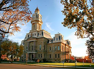
Madison County is a county located in the central portion of the U.S. state of Ohio. As of the 2020 census, the population was 43,824. Its county seat is London. The county is named for James Madison, President of the United States and was established on March 1, 1810.

<span class="mw-page-title-main">Carroll County, Ohio</span> County in Ohio, United States

Carroll County is a county located in the state of Ohio. As of the 2020 census, the population was 26,721. Its county seat is Carrollton, while its largest village is Minerva. It is named for Charles Carroll of Carrollton, the last surviving signer of the Declaration of Independence.

<span class="mw-page-title-main">Salineville, Ohio</span> Village in Ohio, United States

Salineville is a village in southwestern Columbiana County, Ohio, United States. The population was 1,206 at the 2020 census. It is part of the Salem micropolitan area, about 20 miles (32 km) northwest of Steubenville and 34 miles (55 km) southwest of Youngstown.

<span class="mw-page-title-main">Amsterdam, Ohio</span> Village in Ohio, United States

Amsterdam is a village in northwestern Jefferson County, Ohio, United States. The population was 436 at the 2020 census. The community was founded by Dutch immigrant David Johnson and named after the city of Amsterdam, Netherlands. It is part of the Weirton–Steubenville metropolitan area.

<span class="mw-page-title-main">Bergholz, Ohio</span> Village in Ohio, United States

Bergholz is a village in northwestern Jefferson County, Ohio, United States. The population was 544 at the 2020 census. The village's name is German and translates to "mountain timber". It is part of the Weirton–Steubenville metropolitan area.

<span class="mw-page-title-main">Bloomingdale, Ohio</span> Village in Ohio, United States

Bloomingdale is a village in central Jefferson County, Ohio, United States. The population was 145 at the 2020 census. It is part of the Weirton–Steubenville metropolitan area.

<span class="mw-page-title-main">Dillonvale, Jefferson County, Ohio</span> Village in Ohio, United States

Dillonvale is a village in southern Jefferson County, Ohio, United States. The population was 589 at the 2020 census. It is part of the Weirton–Steubenville metropolitan area. Charles Eberle was the very first mayor of Dillonvale and was the first Postmaster as well.

<span class="mw-page-title-main">Empire, Ohio</span> Village in Ohio, United States

Empire is a village in northeastern Jefferson County, Ohio, United States, along the Ohio River. The population was 232 at the 2020 census. It is part of the Weirton–Steubenville metropolitan area.

<span class="mw-page-title-main">Irondale, Ohio</span> Village in Ohio, United States

Irondale is a village in northern Jefferson County, Ohio, United States. The population was 326 at the 2020 census. It is part of the Weirton–Steubenville metropolitan area.

<span class="mw-page-title-main">Mingo Junction, Ohio</span> Village in Ohio, United States

Mingo Junction is a village in eastern Jefferson County, Ohio, United States, along the Ohio River. The population was 3,347 at the 2020 census. It is part of the Weirton–Steubenville metropolitan area.

<span class="mw-page-title-main">Mount Pleasant, Ohio</span> Village in Ohio, United States

Mount Pleasant is a village in southern Jefferson County, Ohio, United States. The population was 394 at the 2020 census. It is part of the Weirton–Steubenville metropolitan area. Founded in 1803 by anti-slavery Quakers, the village was an early center of abolitionist activity and a well-known haven for fugitive slaves on the Underground Railroad.

<span class="mw-page-title-main">New Alexandria, Ohio</span> Village in Ohio, United States

New Alexandria is a village in eastern Jefferson County, Ohio, United States. The population was 232 at the 2020 census. It is part of the Weirton–Steubenville metropolitan area.

<span class="mw-page-title-main">Rayland, Ohio</span> Village in Ohio, United States

Rayland is a village in southern Jefferson County, Ohio, United States, along the Ohio River. The population was 389 at the 2020 census. It is part of the Weirton–Steubenville metropolitan area.

<span class="mw-page-title-main">Richmond, Ohio</span> Village in Ohio, United States

Richmond is a village in central Jefferson County, Ohio, United States. The population was 412 at the 2020 census. It is part of the Weirton–Steubenville metropolitan area.

<span class="mw-page-title-main">Smithfield, Ohio</span> Village and Census-designated place in Ohio, United States

Smithfield was a village in Smithfield Township, Jefferson County, Ohio, United States. The population was 869 at the 2010 census. It is part of the Weirton–Steubenville, WV-OH Metropolitan Statistical Area. In 2019, Smithfield voted to dissolve itself.

<span class="mw-page-title-main">Tiltonsville, Ohio</span> Village in Ohio, United States

Tiltonsville is a village in southern Jefferson County, Ohio, United States, along the Ohio River. The population was 1,259 at the 2020 census. It is a part of the Weirton–Steubenville metropolitan area.

<span class="mw-page-title-main">Toronto, Ohio</span> City in Ohio, United States

Toronto is a city in eastern Jefferson County, Ohio, located along the Ohio River 6 miles (9.7 km) northeast of Steubenville. The population was 5,303 at the time of the 2020 census, making it the second-largest city in Jefferson County. It is part of the Weirton–Steubenville metropolitan area.

<span class="mw-page-title-main">Wintersville, Ohio</span> Village in Ohio, United States

Wintersville is a village in central Jefferson County, Ohio, United States. The population was 3,609 as of the 2020 Census. It is part of the Weirton–Steubenville metropolitan area. The village is suburban in nature and is governed by a mayor and council elected by non-partisan ballot.

<span class="mw-page-title-main">Yorkville, Ohio</span> Village in Ohio, United States

Yorkville is a village in Belmont and Jefferson counties in the U.S. state of Ohio. The population was 968 at the 2020 census. Yorkville lies within two Metropolitan Statistical Areas; the Belmont County portion is part of the Wheeling metropolitan area, while the Jefferson County portion is part of the Weirton–Steubenville metropolitan area.

<span class="mw-page-title-main">Adena, Ohio</span> Village in Ohio, United States

Adena is a village in southwestern Jefferson and southeastern Harrison counties in the U.S. state of Ohio. The population was 664 at the 2020 census. It is part of the Weirton–Steubenville metropolitan area.

References

  1. "Ohio County Profiles: Jefferson County" (PDF). Ohio Department of Development. Archived from the original (PDF) on June 21, 2007. Retrieved April 28, 2007.
  2. 1 2 2020 census
  3. "Find a County". National Association of Counties. Archived from the original on May 31, 2011. Retrieved June 7, 2011.
  4. "Jefferson County data". Ohio State University Extension Data Center. Retrieved April 28, 2007.[ dead link ]
  5. "Archived copy" (PDF). Office of Management and Budget. Archived (PDF) from the original on January 21, 2017. Retrieved January 4, 2017 via National Archives.{{cite web}}: CS1 maint: archived copy as title (link)
  6. "2010 Census Gazetteer Files". United States Census Bureau. August 22, 2012. Archived from the original on May 4, 2014. Retrieved February 8, 2015.
  7. "U.S. Decennial Census". United States Census Bureau. Retrieved February 8, 2015.
  8. "Historical Census Browser". University of Virginia Library. Retrieved February 8, 2015.
  9. Forstall, Richard L., ed. (March 27, 1995). "Population of Counties by Decennial Census: 1900 to 1990". United States Census Bureau. Retrieved February 8, 2015.
  10. "Census 2000 PHC-T-4. Ranking Tables for Counties: 1990 and 2000" (PDF). United States Census Bureau. April 2, 2001. Retrieved February 8, 2015.
  11. "U.S. Census website". United States Census Bureau . Retrieved January 31, 2008.
  12. 1 2 3 "DP-1 Profile of General Population and Housing Characteristics: 2010 Demographic Profile Data". United States Census Bureau. Archived from the original on February 13, 2020. Retrieved December 27, 2015.
  13. "Population, Housing Units, Area, and Density: 2010 - County". United States Census Bureau. Archived from the original on February 13, 2020. Retrieved December 27, 2015.
  14. "DP02 SELECTED SOCIAL CHARACTERISTICS IN THE UNITED STATES – 2006-2010 American Community Survey 5-Year Estimates". United States Census Bureau. Archived from the original on February 13, 2020. Retrieved December 27, 2015.
  15. "DP03 SELECTED ECONOMIC CHARACTERISTICS – 2006-2010 American Community Survey 5-Year Estimates". United States Census Bureau. Archived from the original on February 13, 2020. Retrieved December 27, 2015.
  16. Leip, David. "Dave Leip's Atlas of U.S. Presidential Elections". uselectionatlas.org. Retrieved May 2, 2018.
  17. "Elected Officials - Jefferson". Jefferson County Board of Elections. January 14, 2023. Retrieved January 16, 2023.
  18. Carroll County Website Retrieved May 13, 2021.
  19. "TOWNSHIP WEBSITES - Ohio Township Association". July 15, 2016. Archived from the original on July 15, 2016.
  20. J. A. Caldwell: History of Belmont and Jefferson Counties, Ohio, Historical Publishing Co., Wheeling, W.Va., 1880, p. 605, reprinted 1983.
  21. Julie Minot Overton, with Kay Ballantyne Hudson and Sunda Anderson Peters eds.: Ohio Towns and Townships to 1900: A Location Guide, The Ohio Genealogical Society, Mansfield, O. (Penobscot Press), 2000, p. 59.
  22. "2010 U.S. Census website". United States Census Bureau . Retrieved February 13, 2016.

40°23′N80°46′W / 40.38°N 80.76°W / 40.38; -80.76