Peters Township, Washington County, Pennsylvania

Last updated

Peters Township, Pennsylvania
Enoch Wright House.jpg
The Enoch Wright House on Venetia Road
Map of Peters Township, Washington County, Pennsylvania Highlighted.png
Map of Washington County, Pennsylvania highlighting Peters Township
Map of Pennsylvania highlighting Washington County.svg
Map of Washington County, Pennsylvania
CountryUnited States
State Pennsylvania
County Washington
Established1781
Government
  Type Council
  ChairmanFrank Kosir, Jr.
Area
[1]
  Total19.72 sq mi (51.08 km2)
  Land19.55 sq mi (50.63 km2)
  Water0.18 sq mi (0.46 km2)
Population
 (2020)
  Total22,915 Increase2.svg
  Estimate 
(2021) [2]
23,029
  Density1,132.81/sq mi (437.39/km2)
Time zone UTC-5 (Eastern (EST))
  Summer (DST) UTC-4 (EDT)
Area code 724
FIPS code 42-125-59608
Website http://www.peterstownship.com/

Peters Township is a township in Washington County, Pennsylvania, United States. The population was 22,915 at the 2020 census. [2] It is a suburb of the Pittsburgh metropolitan area.

Contents

History

Peters Township was incorporated in 1781 as one of Washington County's thirteen original townships. It had fallen within the area claimed by Virginia as its Yohogania County before the resolution of that state's boundary dispute with Pennsylvania. Over the years, portions of Peters Township were sectioned off to form other municipalities; eventually, leaving the present configuration of 19.5 square miles (51 km2).

Peters Township was named after William "Indian" Peters. There is uncertainty regarding Peters' race, with some sources holding that he was an Indian and others that he was a white man who traded with local Indians. Regardless, the Indian name has long-been associated with Peters Township.

Some of the first settlers were James and Joshua Wright, James Matthews, John Sweringer, Rev. David Phillips, Andrew Dunlevy, Daniel Townsend, William Fife and Robert Bell. Peters was initially a farming community and then later on coal became a major industry that resulted in the development of Hackett, presently a small settlement 1.2 miles (2 km) east of Venetia.

Peters Township remained a sparsely populated rural community until the 1950s. In 1950 the population was 3,004. By 2000, this number had increased to 17,556. In 1976, the township's home rule charter became effective. This altered the form of government from the prevalent Second Class Township Supervisor format to the present Council-Manager form.

The township's current arrowhead logo was adopted with the new home rule charter. An arrowhead found in Peters Township was adopted as the pattern. [3]

Peterswood Park, located in the township, is home to the Peters Township Recreation Center, as well as several football, baseball, softball, and soccer fields. In addition, there is an amphitheater as well as several pavilions.

The Enoch Wright House was listed on the National Register of Historic Places in 2007. [4]

Geography

According to the United States Census Bureau, the township has a total area of 19.8 square miles (51.2 km2), of which 19.6 square miles (50.7 km2) is land and 0.2 square miles (0.5 km2) is water. The main thoroughfares in Peters Township are U.S. Route 19 heading north and south, and East McMurray Road heading east and west.

Communities

Peters Township is made up of two sub-communities. These are:

Surrounding neighborhoods

Peters Township has six borders, including Upper St. Clair Township and Bethel Park (both in Allegheny County) to the north, Union Township to the east, Nottingham Township to the south, North Strabane Township to the south and southwest, and Cecil Township to the west.

Demographics

Historical population
CensusPop.Note
2000 17,566
2010 21,21320.8%
2020 22,9158.0%
2021 (est.)23,029 [2] 0.5%
U.S. Decennial Census [5]

2000 census

As of the census [6] of 2000, there were 17,566 people, 6,026 households, and 5,091 families living in the township. The population density was 896.6 inhabitants per square mile (346.2/km2). There were 6,221 housing units at an average density of 317.5 per square mile (122.6/km2). The racial makeup of the township was 97.81% White, 0.48% African American, 0.03% Native American, 1.09% Asian, 0.03% Pacific Islander, 0.20% from other races, and 0.37% from two or more races. Hispanic or Latino of any race were 0.72% of the population.

There were 6,026 households, out of which 41.8% had children under the age of 18 living with them, 77.5% were married couples living together, 5.2% had a female householder with no husband present, and 15.5% were non-families. 13.8% of all households were made up of individuals, and 6.1% had someone living alone who was 65 years of age or older. The average household size was 2.87 and the average family size was 3.17.

The population spread consisted of 29.4% under the age of 18, 4.1% from 18 to 24, 25.4% from 25 to 44, 28.2% from 45 to 64, and 13.0% who were 65 years of age or older. The median age was 41 years. For every 100 females there were 94.3 males. For every 100 females age 18 and over, there were 91.6 males.

The median income for a household in the township was $102,320 and the median income for a family was $108,246 (2007 estimate). [7] The per capita income for the township was $36,606. About 1.1% of families and 1.7% of the population were below the poverty line, including 1.1% of those under age 18 and 1.5% of those age 65 or over.

2010 census

As of the census [8] of 2010, there were 21,213 people, 7,292 households, and 6,079 families living in the township. The population density was 1,071.4 inhabitants per square mile (413.7/km2). There were 7,559 housing units at an average density of 381.8 per square mile (147.4/km2). The racial makeup of the township was 96.2% White, 0.5% African American, 0.1% Native American, 2.0% Asian, 0.3% from other races, and 0.9% from two or more races. Hispanic or Latino of any race were 1.5% of the population.

Of the 7,292 total households, 40.7% had children under the age of 18 living with them, 75.3% were married couples living together, 5.4% had a female householder with no husband present, and 16.6% were non-families. 14.2% of all households were made up of individuals, and 5.9% had someone living alone who was 65 years of age or older. The average household size was 2.88 and the average family size was 3.20.

The average income per household is $155,752. In the township the population was spread out, with 31.1% under the age of 18, 2.7% from 18 to 24, 19.7% from 25 to 44, 33.1% from 45 to 64, and 13.4% who were 65 years of age or older. The median age was 43 years. For every 100 females there were 96.7 males. For every 100 women age 18 and over, there were 93.3 men.

Community services

Fire department

The Peters Township Fire Department, originally established in 1937 as an all-volunteer organization, has grown to a combination department with a total of 45 career and volunteer firefighters. The department operates out of three fire stations within the township and maintains a fleet of three engines, one heavy rescue, one 109' aerial quint, and a number of specialized squads. The department provides emergency response for fire, rescue, emergency medical and other requests to Peters Township and surrounding residents.

Education

The Peters Township School District has two elementary schools (Bower Hill Elementary School and Pleasant Valley Elementary School) that educate students in grades K-3. These elementary schools are split for the individual communities (McMurray and Venetia for Pleasant Valley and Bower Hill respectively).

The secondary elementary school (McMurray Elementary School) educates students in grades 4–5. The Peters Township Middle School educates students in grades 6–8. The Peters Township High School educates students in grades 9-12.

Related Research Articles

<span class="mw-page-title-main">Conoy Township, Pennsylvania</span> Township in Pennsylvania, United States

Conoy Township is a township in northwestern Lancaster County, Pennsylvania, United States. At the 2020 census, the population was 3,373.

<span class="mw-page-title-main">Santa Venetia, California</span> Census-designated place in California, United States

Santa Venetia is a census-designated place (CDP) in Marin County, California, United States. It is located 1.5 miles (2.4 km) north of downtown San Rafael, at an elevation of 56 feet (17 m). The population was 4,289 at the 2020 census.

<span class="mw-page-title-main">Fairview Heights, Illinois</span> City in Illinois, United States

Fairview Heights is a city in St. Clair County, Illinois, United States within Greater St. Louis. It is an eastern suburb of St. Louis. The population was 17,078 at the 2010 census. Fairview Heights is a dominant shopping center for Greater St. Louis and Southern Illinois and includes numerous shopping plazas and St. Clair Square mall.

<span class="mw-page-title-main">Saint Joe, Indiana</span> Place in Indiana, United States

Saint Joe is a town in Concord Township, DeKalb County, Indiana, United States. The population was 460 at the 2010 census.

<span class="mw-page-title-main">Syracuse, Indiana</span> Town in Indiana, United States

Syracuse is a town in Turkey Creek Township, Kosciusko County, in the U.S. state of Indiana. The population was 3,079 at the 2020 census. Syracuse is the location of Lake Syracuse and the nearby, larger Lake Wawasee, in addition to several other lakes in the region. The National Weather Service operates a Weather Forecast Office in the town. It serves Northern Indiana.

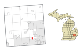
Pennfield Charter Township is a charter township of Calhoun County in the U.S. state of Michigan. It is part of the Battle Creek, Michigan Metropolitan Statistical Area. The population was 9,001 at the 2010 census.

<span class="mw-page-title-main">Bingham Farms, Michigan</span> Village in Michigan, United States

Bingham Farms is a village in Oakland County in the U.S. state of Michigan. A northern suburb of Detroit, Bingham Farms is located within Southfield Township, roughly 20 miles (32.2 km) northwest of downtown Detroit. As of the 2020 census, the village had a population of 1,124.

<span class="mw-page-title-main">Coopersville, Michigan</span> City in Ottawa County, Michigan, United States

Coopersville is a city located in north central Ottawa County in the U.S. state of Michigan. The population was 4,828 at the 2020 census. It is primarily a farming community.

<span class="mw-page-title-main">Morganville, New Jersey</span> Populated place in Monmouth County, New Jersey, US

Morganville is an unincorporated community and census-designated place (CDP) within Marlboro Township, in Monmouth County, New Jersey. As of the 2010 United States Census, the CDP's population was 5,040.

<span class="mw-page-title-main">East Canton, Ohio</span> Village in Ohio, United States

East Canton is a village in central Stark County, Ohio, United States. The population was 1,521 at the 2020 census. It is part of the Canton–Massillon metropolitan area.

<span class="mw-page-title-main">Middlesex Township, Butler County, Pennsylvania</span> Township in Pennsylvania, United States

Middlesex Township is a township in Butler County, Pennsylvania, United States. The population was 6,826 at the 2020 census.

<span class="mw-page-title-main">Schuylkill Township, Chester County, Pennsylvania</span> Township in Pennsylvania, United States

Schuylkill Township is a township in Chester County, Pennsylvania, United States. It contains the village of Valley Forge. The population was 8,516 at the 2010 census.

<span class="mw-page-title-main">Wallace Township, Pennsylvania</span> Township in Pennsylvania, United States

Wallace Township is a township in Chester County, Pennsylvania, United States. The population was 3,458 at the 2010 census.

<span class="mw-page-title-main">Halifax Township, Pennsylvania</span> Township in Pennsylvania, United States

Halifax Township is a township in Dauphin County, Pennsylvania, United States. The population was 3,336 at the 2020 census.

<span class="mw-page-title-main">Rush Township, Dauphin County, Pennsylvania</span> Township in Pennsylvania, United States

Rush Township is a township in Dauphin County, Pennsylvania, United States. As of the 2020 census, the township population was 226, a decline from the figure of 231 tabulated in 2000.

<span class="mw-page-title-main">North Abington Township, Lackawanna County, Pennsylvania</span> Place in Pennsylvania, United States

North Abington Township is a township in Lackawanna County, Pennsylvania, United States. It is located approximately 10 miles (16 km) north of Scranton, Pennsylvania, and is located in the suburban area known as “the Abingtons". North Abington is also approximately 6 miles (10 km) north of Clarks Summit and borders Waverly Township and Dalton Borough to the south, as well as Benton Township to the north. The population was 709 at the 2020 census.

<span class="mw-page-title-main">South Abington Township, Pennsylvania</span> Place in Pennsylvania, United States

South Abington Township is a township in Lackawanna County, Pennsylvania, United States. The population was 9,526 at the 2020 census. The census-designated place of Chinchilla is within the township. South Abington Township is the northern terminus of the Pennsylvania Turnpike Northeast Extension (I-476).

<span class="mw-page-title-main">Upper Milford Township, Pennsylvania</span> Township in Pennsylvania, United States

Upper Milford Township is a township in Lehigh County, Pennsylvania. The township's population was 7,292 at the 2010 census. Upper Milford Township is a suburb of Allentown in the Lehigh Valley, which had a population of 861,899 and was the 68th-most populous metropolitan area in the U.S. as of the 2020 census.

<span class="mw-page-title-main">Kline Township, Schuylkill County, Pennsylvania</span> Township in Pennsylvania, United States

Kline Township is a township in Schuylkill County, Pennsylvania. The population was 1,473 at the 2020 census.

<span class="mw-page-title-main">Oakland, Douglas County, Wisconsin</span> Town in Wisconsin, United States

Oakland is a town in Douglas County, Wisconsin, United States. The population was 1,144 at the 2000 census.

References

  1. "2016 U.S. Gazetteer Files". United States Census Bureau. Retrieved August 14, 2017.
  2. 1 2 3 Bureau, US Census. "City and Town Population Totals: 2020-2021". Census.gov. US Census Bureau. Retrieved July 21, 2022.
  3. History of Peters Township Archived March 16, 2007, at the Wayback Machine
  4. "National Register Information System". National Register of Historic Places . National Park Service. July 9, 2010.
  5. "Census of Population and Housing". Census.gov. Retrieved June 4, 2016.
  6. "U.S. Census website". United States Census Bureau . Retrieved January 31, 2008.
  7. "FactFinder". Archived from the original on February 16, 2020. Retrieved April 1, 2009.
  8. "Profile of General Population and Housing Characteristics: 2010" (PDF). American Fact Finder. United States Census Bureau. Archived from the original (PDF) on March 21, 2012. Retrieved September 5, 2011.

40°16′30″N80°5′30″W / 40.27500°N 80.09167°W / 40.27500; -80.09167