Jefferson County Airpark

Last updated
Jefferson County Airpark (Steubenville, Ohio)
Summary
Airport typePublic
OwnerJefferson County Commissioners
OperatorJefferson County Regional Airport Authority
Serves Steubenville, Ohio
Location Cross Creek Township, Ohio
Elevation  AMSL 1,030 ft / 314 m
Coordinates 40°21′36.8″N080°42′03.2″W / 40.360222°N 80.700889°W / 40.360222; -80.700889
Website JeffersonCountyAirpark.org
Map
USA Ohio relief location map.svg
Airplane silhouette.svg
2G2
Location in Ohio
Usa edcp relief location map.png
Airplane silhouette.svg
2G2
Location in United States
Runways
Direction LengthSurface
ftm
14/325,0011,341 Paved
Statistics (2022)
Aircraft operations10,585
Based aircraft34

Jefferson County Airpark (Steubenville, Ohio)( FAA LID : 2G2), is a full-service general aviation public airport near Steubenville, Ohio, U.S., part of the Pittsburgh Combined Statistical Area that serves small and mid-sized private, corporate and commercial traffic. The airport serves transients traveling to and from Eastern Ohio, the Northern Panhandle of West Virginia, and Western Pennsylvania (Pittsburgh). The airport founded in January 1948 by R. G. and Pauline Pier as Pier Airport.

Contents

History

Coal mine to Airfield (1940s - 1992)

Rene Pier purchased the land on which the Jefferson County Airpark is located in the early 1940s to conduct strip-mining operations. After mining operations were completed around 1950, the property owner constructed a slag-surfaced runway and erected two large hangars that were procured from military surplus stock. Through the 1950s and 1960s the government encouraged flying and the airport saw thriving times. During this era about 50 aircraft were based at what was then known as the Pier Airport.

In the early 1980s Mr. Dominic Teramana purchased the airport site and operated the facility for about five years. He sold the 385-acre tract of land to the board of commissioners of Jefferson County, Ohio, in 1985 for $225,000. In early 1992, a group of pilots realized Jefferson County lacked an essential asset of any progressive community – an adequate airport. The group also understood that an airport is a tool to be used by business and is an incentive for attracting new business. They believed if the airport was to survive they had to act. From these aviators grew the theory of an airport management board that would consist of skilled pilots and successful business people using sound business practices to build a successful airport.

Rebuilding an Airport (1992-1996)

On July 23, 1992, the Jefferson County Board of Commissioners adopted a resolution establishing an airport authority. The commissioners signing the document were William Crabbe, Albert Olexia and Edward Swiger. They named the following to serve as the charter members of the board of trustees of the Jefferson County Regional Airport Authority (JCRAA): Geary Bates, Phillip Bender, Ralph Freshwater, Gary Smith, and Terry Sterling. The board members served in a non-compensated capacity. Mr. Bender was selected to serve as the first Board president. Charles Edwards consented to serve as solicitor and David Hunt assumed the duties of clerk. Thus began the task of drafting a facilities management agreement, by-laws, rules and regulations, and setting goals.

The Jefferson County Commissioners had contracted, in 1988, with Richland Engineering Limited of Mansfield, Ohio to produce an airport master plan. It had been completed for years but was not used until the new board began the task assigned to it. Needs were prioritized and action commenced.

The board members, and others, worked hard to accomplish much with little. These non-compensated Trustees donated time, equipment, material, and energy to the gargantuan task facing them. A courtesy car was needed; a board member donated it. A riding mower was needed; a board member donated it. Two board members donated large tractors with brush hogs and operators. Several pilots volunteered their mowers and use of their snowplow equipped trucks for snow removal. Finally, the budget afforded the purchase of a snow blade. But, there was still no truck, so it was fitted on a large dump truck loaned by a board member. The airport used that loaned truck until December, 1998 when a used snow plow was purchased at auction from the Wheeling – Ohio County Airport.

While operations continued, the board members also concentrated on working with Richland Engineering Ltd. to implement the provisions of the airport improvement plan. Thanks to Mr. Dominic Teramana, the trustees were informed that coal lay beneath the proposed construction areas of the airport. The county commissioners approved the use of any money derived from coal sales for capital improvements. The removal and sale of the coal that lay beneath the runway extension area proved to be extremely beneficial. The proceeds enabled the board to purchase a tractor with a blade, a loader, and a mower.

Meanwhile, the trustees prioritized the necessary capital improvements, namely a fuel storage facility, terminal building, new hangars, and adequate parking. In early 1995 a contract was signed for the purchase of four hangar parks, at eight units each. Pilots using the field, along with others, committed to renting these hangars. The terminal building was the first building constructed. Money from coal sales, student labor from the Jefferson County Joint Vocational School, and volunteer labor, mostly from pilots, resulted in the successful completion of the terminal building at a cost less than $50,000.

Installation of utilities quickly followed the construction of the terminal building. Even though only electricity was needed for the four hangar buildings that would soon be constructed, water, sewer, and telephone services were also installed. Local businesses volunteered machinery, equipment, and labor and the board members loaned equipment and operators to complete the project. Backhoes and bulldozers worked weeks to dig hundreds of feet of ditching for these utilities.

The board not only had the burden of operations and reconstruction; they also oversaw the coal removal operations. This, in itself, presented numerous problems – licensing, product marketing, and sales fluctuations, to name just a few. Trustee Geary Bates assumed the responsibility of the coal operations, which reaped monetary rewards for the Airpark.

Volunteer labor, donated materials and equipment, and hours of hard work resulted in great savings. It is estimated that these factors saved the County in excess of $320,000.

On July 26, 1996, the board of trustees of the Jefferson County Regional Airport Authority dedicated its reconstructed airport in the presence of various federal, state, and local government officials and friends of the airport. The first phase of what is an ongoing effort to improve the airport and its facilities was brought to a close.

The renovated facility boasted a full-time airport management team, a 10,000-gallon above-ground fuel facility, parking, 32 T-hangars, a passenger terminal and lounge, flight school and flight training, pilot supplies, ground transportation, a public telephone, a pilots' lounge and snooze room, restrooms, and snack machines. In addition, the access road is paved, the existing runway is 3,500 feet by 60 feet (compared to the previous 3,200 feet by 32 feet runway), a new taxiway (which is three-quarters the length of the runway), new lighting systems for the runway and taxiway, a new ramp area, and grading and seeding of the entire surrounding area.

1996-Present

Mr. Eric Bates of Bates Bros. Amusements was the first business to realize the advantages of being located at the Airpark. Subsequently, Mr. Bates expanded his operation intro three additional businesses, namely A.R.M. U.S., American Superior Lighting, and Illumitec.

In August 1998 the board successfully petitioned the Jefferson County Commissioners to purchase, at a cost of $350,000, a 167-acre farm that was adjacent to the Airpark. It and the Airpark were only separated by County Road 33 at the 14 end of the runway. This land purchase permitted the expansion and improvement of the Airpark. This move allowed the authority to begin the second phase of the twenty-year airport improvement plan. The first step of this phase was the removal of a small hill and tree obstructions located on the newly purchased land. The second step was the relocation of County Road 33 to accommodate the extension of the runway. This extension increased the length of the runway to its current 4400 feet with room to grow to 5000 feet. This expansion was followed by the addition of a second 10,000-gallon above-ground fuel tank to allow the sale of jet fuel.

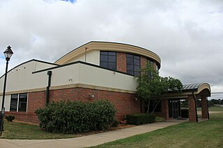
In June 2007 ground was broken for a new terminal building, with construction completed a year later. Located southeast from the old terminal across the apron, the new facility is situated roughly mid-field with a view from one end of the runway to the other. With nearly double the amount of available space, the new building allows the Airpark to increase the conveniences and amenities provided to pilots. The Airpark now has multiple bathrooms equipped with showers, a dedicated pilots' lounge/snooze room, a flight-planning room, and a larger conference room available for meetings or presentations.

In April 2008 STAT MedEvac, a division of the Center for Emergency Medicine of Western Pennsylvania, became based at the Airpark.

April 2009 saw the beginning of construction on a new 60 by 60-foot hangar for corporate aircraft. This new hangar is located near the location of the original hangars towards the southeast end of the airfield. On April 16, 2010, a windstorm damaged the old hangars. The roof of the smaller of the World War II surplus hangars was lifted off of its framework and dropped onto the larger of the two. The related damage sustained to the structures rendered the buildings unsound and they were condemned. Although they were the most visible links to the airport's history, they will be replaced with new hangars along with further renovations of the apron area at the southeast end of the field.

Future

The original investment of $225,000 grew to more than $3 million and at little cost to Jefferson County. The Airport Authority cooperates with the FAA, ODOT, and the state, county, and local government officials.

Facilities and aircraft

The Geary A Bates/Jefferson County Airpark has one runway, designated as runway 14/32. It measures 5001 x 75 ft (1524 x 23 m) and is paved with asphalt. [2]

The airport has a fixed-base operator that sells fuel, both avgas and jet fuel. It offers services such as catering, courtesy cars, and more in addition to amenities such as internet, conference rooms, a crew lounge, showers, and more. [3]

For the 12-month period ending September 27, 2022, the airport had 10,585 aircraft operations, an average of 29 per day. It was comprised of 96% general aviation, 2% air taxi, and 1% military. For the same time period, there were 34 aircraft based at the airport: 31 single-engine airplanes, 1 multi-engine airplane, 1 jet, and 1 helicopter. [2]

Accidents and incidents

See also

Related Research Articles

<span class="mw-page-title-main">Greater Rochester International Airport</span> Domestic airport located in Rochester, New York, USA

Frederick Douglass - Greater Rochester International Airport is a public airport located within the City of Rochester, three miles (4.8 km) southwest of Downtown, in Monroe County, New York, United States. It is owned and operated by Monroe County. The airport is home to the 642nd Aviation Support Battalion, part of the 42nd Infantry Division.

<span class="mw-page-title-main">Rocky Mountain Metropolitan Airport</span> Airport in Broomfield, Colorado

Rocky Mountain Metropolitan Airport is a public-use airport located in Broomfield, Colorado, United States. The airport is owned and operated by Jefferson County and is situated midway between Denver and Boulder on U.S. Highway 36. It is located 16 miles (26 km) northwest of the central business district of Denver, and is the closest airport to downtown Denver. The airport covers 1,700 acres (688 ha) and has three runways. Formerly known as Jefferson County Airport or Jeffco Airport, the airport was renamed Rocky Mountain Metropolitan Airport on October 10, 2006, although it is sometimes referred to as Rocky Mountain Regional Airport, e.g., on 2007–2012 county planning documents.

Lima Allen County Airport is a publicly owned, public use airport located six miles southeast of Lima in Allen County, Ohio. It is owned by the Allen County Regional Airport Authority.

<span class="mw-page-title-main">Dayton–Wright Brothers Airport</span> Airport in Montgomery County / Clearcreek Township, Warren County

Dayton–Wright Brothers Airport is a public airport located 10 miles (16 km) south of the central business district of Dayton, Ohio, located mainly in Miami Township, Montgomery County and partly in Clearcreek Township, Warren County, near the suburb of Springboro. It is owned and operated by the City of Dayton and serves as the reliever airport for Dayton International Airport. It mainly serves corporate and personal aircraft users. The airport's identifying code, MGY, is a reference to its former name of Montgomery County Airport.

<span class="mw-page-title-main">Cuyahoga County Airport</span> Airport in Richmond Heights, Willoughby Hills

Cuyahoga County Airport, also known as Robert D. Shea Field, is a public use airport in northeastern Cuyahoga County, Ohio, United States. Owned and operated by Cuyahoga County since 1946, it also serves Lake County and Geauga County. The airport is located 10 nautical miles east of downtown Cleveland and sits on the border of three cities: Highland Heights, Richmond Heights and Willoughby Hills. It is included in the National Plan of Integrated Airport Systems for 2011–2015, which categorized it as a general aviation reliever airport for Cleveland Hopkins International Airport.

Delaware Airpark is a public use airport serving the Dover area. It is owned by the Delaware Department of Transportation and operated by the Delaware River and Bay Authority and located one nautical mile (2 km) west of the central business district of Cheswold, a town in Kent County, Delaware, United States. It is included in the Federal Aviation Administration (FAA) National Plan of Integrated Airport Systems for 2017–2021, in which it is categorized as a local general aviation facility.

<span class="mw-page-title-main">John C. Tune Airport</span> Airport

John C. Tune Airport is a public airport located in the western portion of the city of Nashville in Davidson County, Tennessee, United States. It is owned by the Metropolitan Nashville Airport Authority, located approximately one mile off of Briley Parkway in the Cockrill Bend area. It is a Class D airport.

<span class="mw-page-title-main">Gordon K. Bush Airport</span> Airport

Ohio University Airport or Gordon K. Bush Airport, also known as Snyder Field, is a public-use airport located on State Route 32/U.S. 50 in the village of Albany, about ten miles (16 km) southwest of the city of Athens, in Athens County, Ohio, United States.

<span class="mw-page-title-main">Fallbrook Community Airpark</span> Airport

Fallbrook Community Airpark, also known as Fallbrook Airpark, is a county-owned public-use airport located two nautical miles south of the central business district of Fallbrook, in San Diego County, California, United States.

<span class="mw-page-title-main">Lebanon-Warren County Airport</span> Airport in Lebanon, Ohio

Lebanon-Warren County Airport is a public airport located three miles (5 km) northwest of the central business district of Lebanon, on Greentree Road, in Warren County, Ohio, United States.

Lawrence County Airpark is a public use airport located two nautical miles (3.7 km) west of the central business district of Chesapeake, a village in Lawrence County, Ohio, United States. It is publicly owned by Lawrence County Board of Commissioners. The airport lies across the Ohio River from Huntington, West Virginia.

<span class="mw-page-title-main">Greene County–Lewis A. Jackson Regional Airport</span> Airport in Xenia, Ohio

Greene County–Lewis A. Jackson Regional Airport is a public use airport located in Xenia, a city in Greene County, Ohio, United States. It is 10 nautical miles (19 km) east of the central business district of the city of Dayton.

Arthur Dunn Airpark is a public-use airport located 2 miles (3.2 km) northwest of the central business district of the city of Titusville in Brevard County, Florida, United States. The airport is publicly owned and is administered under the cognizance of the Titusville-Cocoa Airport Authority. The airport has one paved runway that is 2,961 feet in length and a turf runway that is 1,805 feet in length.

<span class="mw-page-title-main">Everglades Airpark</span> Airport in Collier County, Florida

Everglades Airpark is a public-use airport located 1 mile (1.6 km) southwest of the central business district of the city of Everglades City in Collier County, Florida, United States. The airport is publicly owned.

Tri-County Airport is a public-use airport located 5.1 nautical miles northeast of the central business district of the city of Bonifay in Holmes County, Florida, United States and 5.3 miles northwest of the central business district of Chipley, in Washington County, Florida. Created by an act of the Florida legislature in 1969, the airport is publicly owned and serves the Florida communities of Bonifay, Chipley and Graceville, as well as serving as a feeder/general aviation airport for Panama City, Florida and Dothan, Alabama.

<span class="mw-page-title-main">Stevens Field</span> Airport

Stevens Field is a public-use, general aviation airport located three miles northwest of the central business district of Pagosa Springs in Archuleta County, Colorado, United States. It is publicly owned by Archuleta County. It has no air traffic control tower or commercial passenger services, but it does have a fixed base operator (FBO), and it is popular among light sport and general aviation aircraft doing cross country flights, where the airport serves as an GA-friendly waypoint, refueling stop, and pilot rest/sleep opportunity. Its address is 61 Aviation Ct, Pagosa Springs, CO.

Lorain County Regional Airport is a public airport in Lorain County, Ohio, owned by the Lorain County Board of Commissioners and located in New Russia Township. The airport is about 7 miles south of Lorain and 5 miles southwest of Elyria. The National Plan of Integrated Airport Systems for 2011–2015 categorized it as a general aviation reliever airport.

Highland County Airport is a public-owned, public-use airport located at 9500 North Shore Drive three nautical mile (4.8 km) southeast of the central business district of the city of Hillsboro, in Highland County, Ohio, United States.

Northeast Ohio Regional Airport, owned and operated by the Ashtabula County Airport Authority, is a public-use airport in Ashtabula County, Ohio, United States, eight nautical miles (15 km) southeast of the central business district of the city of Ashtabula. Airport is located in Denmark Township near the Village of Jefferson, which is the County Seat of Ashtabula County. Located within minutes of Lake Erie and the intersection of major Interstates 90 (East/West) and 11 (North/South), the convenient location of the Northeast Ohio Regional Airport (HZY) makes it the perfect choice for both corporate and private travelers. The airport is located in the village of Jefferson, about 10 miles (16 km) south of Lake Erie. According to the FAA's National Plan of Integrated Airport Systems for 2009–2013, it is classified as a general aviation airport.

Henry County Airport is a public use airport located three nautical miles (6 km) east of the central business district of Napoleon, a city in Henry County, Ohio, United States. It is owned by the Henry County Airport Authority. This airport is included in the National Plan of Integrated Airport Systems for 2011–2015, which categorized it as a general aviation facility.

References

  1. FAA Airport Form 5010 for 2G2 PDF , effective 2008-02-14
  2. 1 2 "AirNav: 2G2 - Geary A Bates/Jefferson County Airpark". www.airnav.com. Retrieved 2024-04-10.
  3. "Jefferson County Airpark FBO Info & Fuel Prices at Geary a Bates/Jefferson County Airpark (2G2)". FlightAware. Retrieved 2024-04-10.
  4. "Cessna 172G crash in Ohio (N4352L) | PlaneCrashMap.com". planecrashmap.com. Retrieved 2024-04-10.