Green Tree, Pennsylvania

Last updated

Green Tree, Pennsylvania
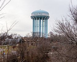
Water Tower in Green Tree, Pennsylvania.jpg
Water tower, visible throughout the borough and surrounding areas
Flag of Green Tree, Pennsylvania.png
Seal of Green Tree, Pennsylvania.png
Allegheny County Pennsylvania incorporated and unincorporated areas Green Tree highlighted.svg
Location in Allegheny County and the state of Pennsylvania.
Coordinates: 40°24′54″N80°2′59″W / 40.41500°N 80.04972°W / 40.41500; -80.04972
CountryUnited States
StatePennsylvania
County Allegheny County
Area
[1]
  Total2.08 sq mi (5.38 km2)
  Land2.08 sq mi (5.38 km2)
  Water0.00 sq mi (0.00 km2)
Population
 (2020) [2]
  Total4,941
  Density2,381.20/sq mi (919.21/km2)
Time zone UTC-5 (EST)
  Summer (DST) UTC-4 (EDT)
FIPS code 42-31256
Website www.greentreeboro.com

Green Tree is a borough in Allegheny County, Pennsylvania, United States. The population was 4,941 at the 2020 census. [3] It is a suburb of the Pittsburgh metropolitan area. Green Tree is connected to Pittsburgh via the Fort Pitt Tunnel.

Contents

History

Settled in 1793, the area stayed rural until the late 1800s, with paintings of the time showing farmland and a vineyard. [4] The community took its name from the local Green Tree Hotel. [5] Rook Station on the Wabash Pittsburgh Terminal Railway opened in 1904 which heralded an industrialisation of the area and the opening of a railroad yard and roundhouse.[ citation needed ]

Geography

Green Tree is located at 40°24′54″N80°2′59″W / 40.41500°N 80.04972°W / 40.41500; -80.04972 (40.414969, −80.049800). [6]

According to the United States Census Bureau, the borough has a total area of 2.1 square miles (5.4 km2), all land.

Surrounding communities

Green Tree has six borders, five with Pittsburgh neighborhoods: Oakwood and Westwood to the north, Ridgemont to the northeast, Banksville to the east, and East Carnegie to the west. The other border is with Scott Township to the south.

Demographics

Historical population
CensusPop.Note
1890 685
1900 678−1.0%
1910 1,14368.6%
1920 1,043−8.7%
1930 1,45739.7%
1940 1,88029.0%
1950 2,81849.9%
1960 5,22685.5%
1970 6,44123.2%
1980 5,722−11.2%
1990 4,905−14.3%
2000 4,719−3.8%
2010 4,432−6.1%
2020 4,94111.5%
Sources: [7] [8] [9] [10] [11] [12] [2]

As of the 2000 census, [11] there were 4,719 people, 1,974 households, and 1,383 families residing in the borough. The population density was 2,247.7 inhabitants per square mile (867.8/km2). There were 2,026 housing units at an average density of 965.0 per square mile (372.6/km2). The racial makeup of the borough was 96.21% White, 0.53% African American, 1.95% Asian, 0.04% from other races, and 1.27% from two or more races. Hispanic or Latino of any race were 0.66% of the population. 22.0% were of German, 20.5% Irish, 16.4% Italian, 8.9% Polish and 7.8% English ancestry.

There were 1,974 households, out of which 24.2% had children under the age of 18 living with them, 60.1% were married couples living together, 6.8% had a female householder with no husband present, and 29.9% were non-families. 26.2% of all households were made up of individuals, and 11.7% had someone living alone who was 65 years of age or older. The average household size was 2.39 and the average family size was 2.89.

In the borough the population was spread out, with 19.4% under the age of 18, 5.6% from 18 to 24, 25.6% from 25 to 44, 27.9% from 45 to 64, and 21.4% who were 65 years of age or older. The median age was 45 years. For every 100 females, there were 91.2 males. For every 100 females age 18 and over, there were 88.1 males.

The median income for a household in the borough was $54,159, and the median income for a family was $63,814. Males had a median income of $42,304 versus $33,438 for females. The per capita income for the borough was $27,480. About 1.7% of families and 2.8% of the population were below the poverty line, including 3.1% of those under age 18 and 3.4% of those age 65 or over.

Economy

Wexford Health Sources has its headquarters in Foster Plaza Two in Green Tree. [13] [14]

The U.S. Department of the Interior's Office of Surface Mining has its Appalachian Regional Coordination Center, including the Pittsburgh Field office and the National Mine Map Repository, in Three Parkway Center in Green Tree. [15]

Government and politics

Presidential election results [16] [17] [18]
Year Republican Democratic Third parties
2020 43%1,41254%1,7601%42
2016 45%1,31151%1,4594%115
2012 50%1,32749%1,2871%26

Notable people

The town is the hometown of U.S. Congressman and 2012 Republican presidential candidate Ron Paul and Star Trek / Heroes star Zachary Quinto, both of whom were born in nearby Pittsburgh.

Related Research Articles

<span class="mw-page-title-main">Aleppo Township, Allegheny County, Pennsylvania</span> Township in Pennsylvania, United States

Aleppo Township is a township in Allegheny County, Pennsylvania, United States. The population was 1,828 at the 2020 census, a decrease from the figure of 1,916 tabulated in 2010.

<span class="mw-page-title-main">Brackenridge, Pennsylvania</span> Borough in Pennsylvania, United States

Brackenridge is a borough in Allegheny County, Pennsylvania, United States, located along the Allegheny River. It is part of the Greater Pittsburgh metropolitan area.

<span class="mw-page-title-main">Bradford Woods, Pennsylvania</span> Borough in Pennsylvania, United States

Bradford Woods is a borough in Allegheny County, Pennsylvania, United States. The population was 1,183 at the 2020 census. A suburb of the Pittsburgh metropolitan area, it is part of the North Allegheny School District and participates in the multi-municipality Northland Public Library. It is home to Bradford Woods Elementary School.

<span class="mw-page-title-main">Bridgeville, Pennsylvania</span> Borough in Pennsylvania, United States

Bridgeville is a borough in Allegheny County, Pennsylvania, United States. The population was 4,804 at the 2020 census. It is a residential suburb of the Pittsburgh metropolitan area.

<span class="mw-page-title-main">Castle Shannon, Pennsylvania</span> Borough in Pennsylvania, United States

Castle Shannon is a borough in Allegheny County, Pennsylvania, United States. The population was 8,249 at the 2020 census. It is part of the Pittsburgh metropolitan area.

<span class="mw-page-title-main">Cheswick, Pennsylvania</span> Borough in Pennsylvania, United States

Cheswick is a borough in Allegheny County, Pennsylvania, United States, along the Allegheny River. The population was 1,672 as of the 2020 census. Cheswick Borough was incorporated in 1902. It is a residential suburb of the Pittsburgh metropolitan area.

<span class="mw-page-title-main">Etna, Pennsylvania</span> Borough in Pennsylvania, United States

Etna is a borough in Allegheny County, Pennsylvania, United States, located across the Allegheny River from Pittsburgh. The population was 3,437 at the 2020 census. It is a suburb of the Pittsburgh metropolitan area.

<span class="mw-page-title-main">Glenfield, Pennsylvania</span> Borough in Pennsylvania, United States

Glenfield is a borough in Allegheny County, Pennsylvania, United States, situated along the Ohio River. The population was two hundred and twelve at the time of the 2020 census.

<span class="mw-page-title-main">Heidelberg, Pennsylvania</span> Borough in Pennsylvania, United States

Heidelberg is a borough located southwest of Pittsburgh in Allegheny County, Pennsylvania, United States. The population was 1,288 at the 2020 census. The borough was named after Heidelberg in Germany, the native home of a large share of the early settlers.

<span class="mw-page-title-main">Ingram, Pennsylvania</span> Borough in Pennsylvania, United States

Ingram is a borough in Allegheny County, Pennsylvania, United States. The population was 3,391 at the 2020 census.

<span class="mw-page-title-main">Mount Oliver, Pennsylvania</span> Borough in Pennsylvania, United States

Mount Oliver is a borough in Allegheny County, Pennsylvania, United States. The population was 3,394 at the 2020 census. It is a largely residential area situated atop a crest about 3 miles (5 km) west of the Monongahela River. The borough is surrounded entirely by the city of Pittsburgh, having resisted annexation attempts by the city.

<span class="mw-page-title-main">Versailles, Pennsylvania</span> Borough in Pennsylvania, United States

Versailles is a borough in Allegheny County, Pennsylvania, United States. At the 2020 census, the population was 1,476.

<span class="mw-page-title-main">West Homestead, Pennsylvania</span> Borough in Pennsylvania, United States

West Homestead is a borough in Allegheny County, Pennsylvania, United States, 8 miles (13 km) southeast of Pittsburgh, on the Monongahela River. Heavy industries associated with nearby steel mills existed here, such as axle works, brickworks, and manufactories of machinery, car wheels, etc. The largest concern was Mesta Machinery, which was one of the world's leading industrial manufacturers from 1898 until 1983. The population was 1,872 at the 2020 census.

<span class="mw-page-title-main">West Mifflin, Pennsylvania</span> Borough in Pennsylvania, United States

West Mifflin is a borough in Allegheny County, Pennsylvania, United States, located southeast of downtown Pittsburgh. The population was 19,589 at the 2020 census. It is named after Thomas Mifflin, 1st Governor of Pennsylvania, signer of the United States Constitution, and 1st Quartermaster General of the United States Army.

<span class="mw-page-title-main">Whitaker, Pennsylvania</span> Borough in Pennsylvania, United States

Whitaker is a borough in Allegheny County, Pennsylvania, United States, and is on the Monongahela River 3 miles (5 km) upriver from Pittsburgh. The population was 1,179 at the 2020 census.

<span class="mw-page-title-main">White Oak, Pennsylvania</span> Borough in Pennsylvania, United States

White Oak is a borough in Allegheny County, Pennsylvania, United States. The population was 7,630 at the 2020 census. It is a suburb of the Pittsburgh metropolitan area. White Oak was named for a stand of white oak trees near the original town site.

<span class="mw-page-title-main">Seven Fields, Pennsylvania</span> Place in Pennsylvania, United States

Seven Fields is a borough in Butler County, Pennsylvania, United States. The population was 2,887 at the 2010 census, an increase from the figure of 1,986 tabulated in 2000.

<span class="mw-page-title-main">Cambridge Township, Crawford County, Pennsylvania</span> Township in Pennsylvania, United States

Cambridge Township is a township in Crawford County, Pennsylvania, United States. The population was 1,447 at the 2020 census.

<span class="mw-page-title-main">Trafford, Pennsylvania</span> Borough in Pennsylvania, United States

Trafford is a borough in Allegheny and Westmoreland counties in the U.S. state of Pennsylvania. Located near Pittsburgh in western Pennsylvania, the borough lies primarily in Westmoreland County; only a small portion extends into Allegheny County. It was incorporated in 1904 from the northernmost corner of North Huntingdon Township, and was named by George Westinghouse for Trafford near Manchester, England. Westinghouse purchased the land in 1902, and the Trafford Foundry began operations on October 3, 1903. The population was 3,317 at the 2020 census. Of this, 3,113 were in Westmoreland County, and only 61 were in Allegheny County.

<span class="mw-page-title-main">Scott Township, Allegheny County, Pennsylvania</span> CDP and Township in Pennsylvania, United States

Scott Township is a township in Allegheny County, Pennsylvania, United States. The population was 17,024 at the 2010 census.
References

  1. "ArcGIS REST Services Directory". United States Census Bureau. Retrieved October 12, 2022.
  2. 1 2 "Census Population API". United States Census Bureau. Retrieved October 12, 2022.
  3. "Explore Census Data".
  4. "Gallery of Paintings by Austin C. Wooster" . Retrieved December 19, 2012.
  5. Ackerman, Jan (May 10, 1984). "Town names carry bit of history". Pittsburgh Post-Gazette. p. 6. Retrieved October 31, 2015.
  6. "US Gazetteer files: 2010, 2000, and 1990". United States Census Bureau. February 12, 2011. Retrieved April 23, 2011.
  7. "Population-Pennsylvania" (PDF). U.S. Census 1910. U.S. Census Bureau. Retrieved November 22, 2013.
  8. "Number and Distribution of Inhabitants:Pennsylvania-Tennessee" (PDF). Fifteenth Census. U.S. Census Bureau.
  9. "Number of Inhabitants: Pennsylvania" (PDF). 18th Census of the United States. U.S. Census Bureau. Retrieved November 22, 2013.
  10. "Pennsylvania: Population and Housing Unit Counts" (PDF). U.S. Census Bureau. Retrieved November 22, 2013.
  11. 1 2 "U.S. Census website". United States Census Bureau . Retrieved January 31, 2008.
  12. "Annual Estimates of the Resident Population". U.S. Census Bureau. Archived from the original on October 19, 2013. Retrieved November 22, 2013.
  13. "Contact Us." Wexford Health Sources. Retrieved on August 14, 2010. "Wexford Health Sources, Inc. 425 Holiday Drive Foster Plaza Two Pittsburgh, PA 15220."
  14. Twedt, Steve. "Wexford Health works with inmates." Pittsburgh Post-Gazette . Sunday April 12, 2009. Retrieved on August 14, 2010.
  15. Bernhard, Karrie. "Office of Surface Mining Reclamation and Enforcement Appalachian Region" . Retrieved November 22, 2011.
  16. EL. "2012 Allegheny County election". Pittsburgh Tribune-Review. Retrieved October 15, 2017.
  17. EL. "2016 Pennsylvania general election results". Pittsburgh Post-Gazette. Retrieved October 15, 2017.
  18. "Election Night Reporting".
Preceded by Bordering communities
of Pittsburgh
Succeeded by