
Athens is a city and the county seat of Athens County, Ohio, United States. The population was 23,849 at the 2020 census. Located along the Hocking River within Appalachian Ohio about 65 miles (105 km) southeast of Columbus, Athens is best known as the home of Ohio University, a large public research university with an undergraduate and graduate enrollment of more than 21,000 students. It is the principal city of the Athens micropolitan area.

Springfield is a city in and the county seat of Clark County, Ohio, United States. The municipality is located in southwestern Ohio and is situated on the Mad River, Buck Creek, and Beaver Creek, approximately 45 miles (72 km) west of Columbus and 25 miles (40 km) northeast of Dayton. As of the 2020 census, the city had a total population of 58,662, while the Springfield metropolitan area had a population of 136,001 residents.

Bexley is a suburban city in Franklin County, Ohio, United States. The population was 13,928 at the 2020 census. Founded as a village, the city of Bexley is a suburb of Columbus, the Ohio state capital, situated on the banks of Alum Creek next to Driving Park and Wolfe Park, just east of the Franklin Park Conservatory. It is horizontally bisected by the National Road, serving as a reminder of Bexley's origins as a merger between the prestigious Bullitt Park neighborhood to the north, and the Lutheran college community of Pleasant Ridge to the south.

Norwood is the third most populous city in Hamilton County, Ohio, United States, and an enclave of the larger city of Cincinnati. The population was 19,043 at the 2020 census. Originally settled as an early suburb of Cincinnati in the wooded countryside north of the city, the area is characterized by older homes and tree-lined streets.

Mansfield is a city in and the county seat of Richland County, Ohio, United States. Located midway between Columbus and Cleveland via Interstate 71, it is part of Northeast Ohio region in the western foothills of the Allegheny Plateau. The 2020 Census showed that the city had a total population of 47,534, making it the 21st-largest city in Ohio. It lies approximately 65 miles (105 km) southwest of Cleveland, 45 miles (72 km) southwest of Akron, and 65 miles (105 km) northeast of Columbus.

Williamstown is a city in Wood County, West Virginia, United States, along the Ohio River. It is part of the Parkersburg–Vienna metropolitan area. The population was 2,997 at the 2020 census. The now closed Fenton Art Glass Company was located in the city.

Reynoldsburg is a city in Fairfield, Franklin, and Licking counties in the U.S. state of Ohio. It is a suburban community in the Columbus, Ohio metropolitan area. The population was 41,076 at the 2020 census.

Wheeling is a city in the U.S. state of West Virginia. Located almost entirely in Ohio County, of which it is the county seat, it lies along the Ohio River in the foothills of the Appalachian Mountains and also contains a tiny portion extending into Marshall County. Wheeling is located about 60 miles (96 km) west of Pittsburgh and is the principal city of the Wheeling metropolitan area. As of the 2020 census, the city had a population of 27,062, and the metro area had a population of 139,513. It is the fifth most populous city in West Virginia, and the most populous in the state’s Northern Panhandle.

Old Brooklyn is a neighborhood on the West Side of Cleveland, Ohio, United States, located approximately five miles south of downtown Cleveland. It extends east-to-west from the Cuyahoga River to the city of Brooklyn and north-to-south from the Brookside Park Valley to the city of Parma. It is home to the Cleveland Metroparks, including the Cleveland Zoo; the Jesse Owens tree at James Ford Rhodes High School; and the Benjamin Franklin Community Garden, the largest urban community garden in Cuyahoga County. Old Brooklyn has recently adopted the slogan "Old Brooklyn, a great place to grow" to commemorate its history and potential growth.

Sylvania Township is one of the eleven townships of Lucas County, Ohio, United States. As of 2020, the total population was 50,679, making it the second most populous municipality of Lucas County, Northwest Ohio, and the 419 / 567 area codes.

Bruster's Ice Cream, Inc., also known as Bruster's Real Ice Cream or Bruster's, is an American chain of ice cream parlors based in Bridgewater, Pennsylvania. Their primary operating region is in most states east of the Mississippi River. The company's main products are ice cream and frozen yogurt, made on site with a milk-based mix at each individual store and made fresh in order to avoid ice crystal formation. There are 200 independently owned locations in 22 states, Guyana and South Korea.

Handel's Homemade Ice Cream is an ice cream company franchise founded by Alice Handel in 1945 in Youngstown, Ohio. As of January 2024, the company operates 125 corporate and franchise stores in 12 states. Today, it is owned by Leonard Fisher and maintains a corporate headquarters in Canfield, Ohio. Handel's also has its own neighborhood district located in Youngstown.
Riverbend is a neighborhood in southwest Columbus, Ohio. Riverbend itself is a single subdivision that is located next to Big Run Park. Because Riverbend is at the southwest border of the city, it was not annexed into the city until the late 1960s. A major road that serves as the northern boundary of the neighborhood, Clime Road, has segments that have yet to be annexed into the city.
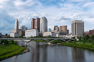
The Columbus, Ohio metropolitan area is a metropolitan area in Central Ohio surrounding the state capital of Columbus. As defined by the U.S. Census Bureau, it includes the counties of Delaware, Fairfield, Franklin, Hocking, Licking, Madison, Morrow, Perry, Pickaway, and Union. At the 2020 census, the MSA had a population of 2,138,926, making it 32nd-most populous in the United States and the second largest in Ohio, behind the Cincinnati metropolitan area. The metro area, also known as Central Ohio or Greater Columbus, is one of the largest and fastest-growing metropolitan areas in the Midwestern United States.

WNDH is a radio station broadcasting a classic hits format. Licensed to Napoleon, Ohio, United States, the station is currently owned by iHeartMedia, Inc.

The Portsmouth Earthworks are a large prehistoric mound complex constructed by the Native American Adena and Ohio Hopewell cultures of eastern North America. The site was one of the largest earthwork ceremonial centers constructed by the Hopewell and is located at the confluence of the Scioto and Ohio Rivers, in present-day Ohio.
Peterborough Tramways served the city of Peterborough from 24 January 1903 until 15 November 1930.
Northwest Columbus is a region in Franklin County, Ohio. It has about 45,000 residents, according to the 2010 U.S. census.
Briggsdale is a neighborhood of Franklin County in the city of Columbus, Ohio. The neighborhood is on the west/southwest side of the city within the Hilltop area. The area was first settled and founded by the family of Joseph M. Briggs, after whom the neighborhood was named. Joseph Briggs was an active figure in the early years of the township and county operations. The Briggsdale Methodist church was founded with his help, and it now exists as the New Horizons Methodist Church. The present-day Briggsdale neighborhood is located near the historical Green Lawn Cemetery to the north as well as Briggs High School to the west.
Tom's Ice Cream Bowl is an ice cream parlor and restaurant in Zanesville, Ohio, founded in 1948 as the Jack Hemmer Ice Cream Company. It is a Zanesville tourist attraction and a cultural icon and institution.

