Jefferson County is a county located in the U.S. state of Ohio. As of the 2020 census, the population was 65,249. Its county seat is Steubenville. The county is named for Thomas Jefferson, who was vice president at the time of its creation.
Calcium is a census-designated place (CDP) in Jefferson County, New York, United States. The population was 3,573 as of the 2020 census. The CDP is in the town of Le Ray and includes the hamlets of Calcium and Sanfords Four Corners.

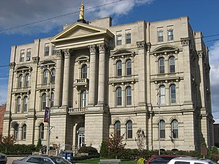
Steubenville is a city in and the county seat of Jefferson County, Ohio, United States. Located along the Ohio River 33 miles (53 km) west of Pittsburgh, it had a population of 18,161 at the 2020 census. The city's name is derived from Fort Steuben, a 1786 fort that sat within the city's current limits and was named for Prussian military officer Baron Friedrich Wilhelm von Steuben. It is a principal city of the Weirton–Steubenville metropolitan area, which had a 2020 population of 116,903 residents.

Burlington is an unincorporated community and census-designated place in Lawrence County, Ohio, United States, along the Ohio River. The population was 2,416 at the 2020 census. Connected to neighboring Huntington, West Virginia and connected via the West Huntington Bridge over the Ohio River, it is part of the Huntington–Ashland metropolitan area. Burlington was once the leading community of Lawrence County, being the first county seat and the location of the county's first post office.

Newell is an unincorporated community and census-designated place in northern Hancock County, West Virginia, United States, along the Ohio River. The population was 1,203 at the 2020 census. It is part of the Weirton–Steubenville metropolitan area and is best known as the home to the Fiesta Tableware Company.

Mallory is a census-designated place (CDP) in Logan County, West Virginia, United States. The population was 1,654 at the 2010 census. The CDP contains the unincorporated communities, from west to east, of Huff Junction, Mallory, Davin, Mineral City, Claypool, Combs Addition, and Gillman Bottom.

Mount Gay-Shamrock is a census-designated place (CDP) in Logan County, West Virginia, United States.
Switzer is an unincorporated community and census-designated place (CDP) in Logan County, West Virginia, United States. The CDP includes the neighboring unincorporated community of Micco. The total CDP population was 595 at the 2010 census.

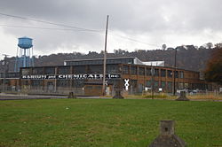
Brilliant is an unincorporated community and census-designated place (CDP) in eastern Jefferson County, Ohio, United States, along the Ohio River. It was named after the Brilliant Glass factory that once was located in the town. The population was 1,317 as of the 2020 census. It is part of the Weirton–Steubenville metropolitan area.
Stone Ridge is a census-designated place in Loudoun County, Virginia, United States. Residences use Aldie mailing addresses, and it is near Washington Dulles International Airport. The population as of the 2020 census was 15,039. Stone Ridge is a Van Metre Homes planned, mixed-use community.
McConnell is an unincorporated community and census-designated place (CDP) in Logan County, West Virginia, United States, on the Guyandotte River. As of the 2010 census, its population was 514. It was established in 1933.
Lansdowne is a census-designated place and planned community located near Leesburg, Virginia in Loudoun County, Virginia. The population as of the 2010 United States Census was 11,253. It is north of State Route 7 and south of the Potomac River. Before the Revolutionary War, the Lee family established Coton Manor here. A section of the Potomac Heritage Trail runs through Lansdowne. It is the home of Inova Loudoun Hospital, the Jack Kent Cooke Foundation, Lansdowne Resort, Prison Fellowship, and Lansdowne Woods of Virginia, a gated, age-restricted community.
Belmont is a census-designated place (CDP) in Loudoun County, Virginia, United States. The population as of the 2010 United States Census was 5,966. It is 5 miles (8 km) southeast of Leesburg, the Loudoun county seat, and 31 miles (50 km) northwest of Washington, D.C. The Belmont Manor House, built between 1799 and 1802 by a son of Richard Henry Lee, is in the northeast part of the CDP and is now the clubhouse for a gated golf community.
Stollings is an unincorporated community and census-designated place (CDP) in central Logan County, West Virginia, United States. As of the 2010 census, it had a population of 316.
University Center is a census-designated place (CDP) in Loudoun County, Virginia, United States. The population as of the 2010 United States Census was 3,586. Mailing addresses in the community are for Ashburn.
Frizzleburg is an unincorporated community and census-designated place (CDP) in Lawrence County, Pennsylvania, United States. The population was 602 at the 2010 census.
Justice Addition is an unincorporated community and census-designated place (CDP) in Logan County, West Virginia, United States. The community was first listed as a CDP prior to the 2020 census. The population was 331 at the 2020 census.
Wolfhurst is a census-designated place (CDP) in Belmont County, Ohio, United States. It is part of the Wheeling, West Virginia Metropolitan Statistical Area. The population was 1,119 at the 2020 census.
Kanauga is an unincorporated community and census-designated place (CDP) in Gallia County, Ohio, United States. As of the 2020 census it had a population of 185.
Suffield is an unincorporated community and census-designated place (CDP) in Suffield Township, Portage County, Ohio, United States. The population was 949 at the 2020 census. It was first listed as a CDP prior to the 2020 census.