
Brilliant is an unincorporated community and census-designated place (CDP) in eastern Jefferson County, Ohio, United States, along the Ohio River. It was named after the Brilliant Glass factory that once was located in the town. The population was 1,317 as of the 2020 census. It is part of the Weirton–Steubenville metropolitan area.

Pettisville is an unincorporated community and census-designated place (CDP) in Clinton and German townships, Fulton County, Ohio, United States. Located at the intersection of County Road 19 and Country Road D, its elevation is 755 feet (230 m). As of the 2020 census the population was 469.

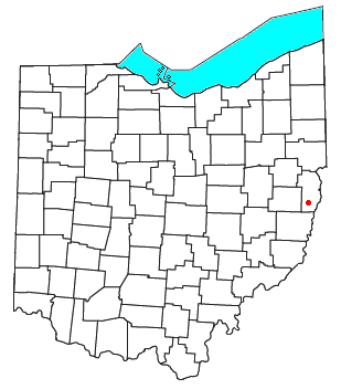
Saline Township is one of the fourteen townships of Jefferson County, Ohio, United States. The 2020 census found 1,171 people in the township.

Roundhead is an unincorporated community in southeastern Roundhead Township, Hardin County, Ohio, United States. It has a post office with the ZIP code 43346.

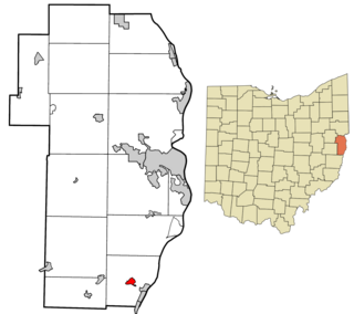
Hammondsville is an unincorporated community in central Saline Township, Jefferson County, Ohio, United States. It is part of the Weirton–Steubenville metropolitan area. It lies along Ohio State Route 213.

East Springfield is a census-designated place (CDP) in northwestern Salem Township, Jefferson County, Ohio, United States. It has a post office with the ZIP code 43925. It lies along State Route 43, 16 miles (26 km) northwest of the county seat of Steubenville and 17 miles (27 km) southeast of Carrollton. The community is part of the Weirton–Steubenville, WV-OH Metropolitan Statistical Area.
Greentown is an unincorporated community in eastern Smithfield Township, Jefferson County, Ohio, United States. It lies approximately 2 miles (3.2 km) south of Smithfield, on a small road. Part of the Dry Fork of Short Creek, a stream that meets the Ohio River at Rayland, flows past the community. It is located 11.7 miles (18.8 km) southwest of Steubenville, the county seat of Jefferson County. The community is part of the Weirton–Steubenville, WV-OH Metropolitan Statistical Area.

Footville is an unincorporated community in southwestern Trumbull Township, Ashtabula County, Ohio, United States. It lies at the intersection of State Route 166 with Trask Road, 1+1⁄2 miles (2.4 km) east of the Geauga County line and 11+1⁄4 miles (18.1 km) southeast of the village of Jefferson, the county seat of Ashtabula County. Spring and Trumbull Creeks, which are both tributaries of the Grand River, pass near Footville.

Lafayette is a census-designated place in the center of Deer Creek Township, Madison County, Ohio, United States. It is located along U.S. Route 40, just west of its intersection with U.S. Route 42. The population of Lafayette was 206 at the 2020 census.

Big Plain is an unincorporated community in Fairfield Township, Madison County, Ohio, United States. It is located at the intersection of West Jefferson-Kiousville Road and Big Plain-Circleville Road, approximately four miles north of Kiousville.

Cassella is an unincorporated community in Marion Township, Mercer County, Ohio, United States. Located at 40°24′22″N84°33′8″W, it lies at an elevation of 955 feet (291 m). Situated at the intersection of State Route 119 and Cassella-Montezuma Road in western Marion Township, it lies in the headwaters of Beaver Creek to the south of the city of Celina, the county seat of Mercer County. Other nearby communities include Maria Stein, 3 miles (4.8 km) to the east, Carthagena, 2 miles (3.2 km) to the north, and St. Henry, 4 miles (6.4 km) to the west.
Calumet is an unincorporated community in Knox Township, Jefferson County, Ohio, United States. It is located just north of Toronto between Ohio State Route 7 and the Ohio River, at 40°28′55″N80°36′24″W. North 4th Street and North River Avenue both run continuously from Toronto to Calumet.
Connorville is an unincorporated community and census-designated place in southern Jefferson County, Ohio, United States. The population was 160 at the 2020 census. It is part of the Weirton–Steubenville metropolitan area.
Emerson is an unincorporated community in Jefferson County, in the U.S. state of Ohio. Emerson is usually considered to be the area that runs from the border of Mount Pleasant, Ohio to the junction between Route 250 and Route 150, and then when both Jefferson and Belmont 5 run into Pleasant Grove, Ohio on Route 250, and then finally when Township Road 128 splits into both the latter and Pinewood Drive, which then runs into Harrisville, Ohio.

Pottery Addition is a census-designated place (CDP) in Jefferson County, Ohio, United States. Its population was 258 as of the 2020 census. The community is located along the Ohio River and is served by Ohio State Route 7.
Altamont is an unincorporated community in Steubenville Township, Jefferson County, Ohio, United States. It is located south of Steubenville and just east of Hillsboro along Wilson Avenue, at 40°20′00″N80°37′03″W.
Broadacre is an unincorporated community in Wayne Township, Jefferson County, Ohio, United States. It is located about 2.5 miles (4.0 km) northeast of Bloomingdale at the intersection of Ohio State Route 152 and Township Route 166, at 40°21′58″N80°46′59″W.
Holt is an unincorporated community in Knox Township, Jefferson County, Ohio, United States. It is located about 3 miles (4.8 km) west of New Somerset at the intersection of County Highway 53 and Township Road 218.
Deandale is an unincorporated community in Steubenville Township, Jefferson County, Ohio, United States. It is located about 1 mile (1.6 km) south of Mingo Junction along Ohio State Route 7.
Yellow Creek is an unincorporated community in Saline Township, Jefferson County, Ohio, United States. It is located northwest of Hammondsville at the intersection of Ohio State Route 7 and Ohio State Route 213 where the Yellow Creek empties into the Ohio River, at 40°34′28″N80°40′03″W.

