Ohio State Route 152

Last updated

OH-152.svg

State Route 152
OH 152 map.svg
Route information
Maintained by ODOT
Length 26.38 mi [1] (42.45 km)
Existed 1923 – present
Southern section
Length 6.18 mi (9.95 km)
South endOH-150.svg SR 150 in Dillonvale
North endOH-151.svg SR 151 in Smithfield
Northern section
Length 20.20 mi (32.51 km)
South endUS 22.svg US 22 in Bloomingdale
North endOH-7.svg SR 7 in Empire
Location
Counties Jefferson
Highway system
OH-151.svg SR 151 SR 153 OH-153.svg

State Route 152 (SR 152) is the designation for two segments of a state highway in Jefferson County, Ohio. The southern segment, which is 6.18 miles (9.95 km) long, runs from SR 150 in Dillonvale to SR 151 in Smithfield. The northern segment, which is 20.20 miles (32.51 km) long, runs from an interchange with U.S. Route 22 (US 22) in Bloomingdale to SR 7 in Empire.

A state highway, state road, or state route is usually a road that is either numbered or maintained by a sub-national state or province. A road numbered by a state or province falls below numbered national highways in the hierarchy. Roads maintained by a state or province include both nationally numbered highways and un-numbered state highways. Depending on the state, "state highway" may be used for one meaning and "state road" or "state route" for the other.

Jefferson County, Ohio County in the United States

Jefferson County is a county located in the U.S. state of Ohio. As of the 2010 census, the population was 69,709. Its county seat is Steubenville. The county is named for Thomas Jefferson, who was Vice President at the time of its creation.

Ohio State of the United States of America

Ohio is a Midwestern state in the Great Lakes region of the United States. Of the fifty states, it is the 34th largest by area, the seventh most populous, and the tenth most densely populated. The state's capital and largest city is Columbus.

Contents

Route description

Looking west along the SR 43-SR 152 concurrency in Richmond Into Richmond, westbound OH43-OH152, Jefferson County.jpg
Looking west along the SR 43–SR 152 concurrency in Richmond

Both segments of SR 152 wholly consist of two-lane roads—one lane in each direction. No part of SR 152 in included in the National Highway System. [2]

National Highway System (United States) highway system in the United States

The National Highway System (NHS) is a network of strategic highways within the United States, including the Interstate Highway System and other roads serving major airports, ports, rail or truck terminals, railway stations, pipeline terminals and other strategic transport facilities. Altogether, it constitutes the largest highway system in the world.

The southern segment of the route begins in the village of Dillonvale at an intersection with SR 150 (Smithfield Street). Immediately, SR 152 heads northwest to cross Piney Fork. The road then parallels the creek as it exits Dillonvale to enter Smithfield Township. It later exits the Piney Fork valley to ascend to a ridge away from the creek. Through this area, single-family houses line both sides of the road. After following the ridgeline for about two miles (3.2 km), SR 152 descends to a valley formed by the Dry Fork southwest of Smithfield. The road soon enters the Smithfield village limits and it heads northeast through the mostly residential neighborhood on Main Street. After descending another hill, this segment of SR 152 ends at an intersection with SR 151 on the north side of the village. [3]

Smithfield Township, Jefferson County, Ohio Township in Ohio, United States

Smithfield Township is one of the fourteen townships of Jefferson County, Ohio, United States. The 2010 census found 3,473 people in the township, 1,819 of whom lived in the unincorporated portions of the township.

The northern segment starts at its southern end at a diamond interchange with US 22 partially in the village Bloomingdale and Wayne Township. South of the interchange, Steubenville Street, the former alignment of US 22 as evidenced by its county road number, Jefferson County Road 22A (CR 22A). SR 152 heads northeast through rolling terrain with few houses and some agricultural businesses. At the next intersection with CR 22A, SR 152 turns off the through road and descends on a winding road to cross Cross Creek and a Columbus and Ohio River Railroad. The road ascends to a ridge line (Quaker Ridge) on a winding road that heads through a mix of forest, open space, and small houses. The road enters Salem Township, treks to the north-northwest, and has an intersection with SR 646. North of this intersection, SR 152 begins to curve to the northeast and enters the village of Richmond on Walnut Street. At the top of a hill, SR 152 reaches Main Street which also carries SR 43. The two highways form a concurrency and travel together southeast ascending a hill. After two blocks, SR 152 turns onto Lisbon Street to continue climbing a hill out of the village. [4]

Diamond interchange common type of road junction

A diamond interchange is a common type of road junction, used where a freeway crosses a minor road.

Wayne Township, Jefferson County, Ohio Township in Ohio, United States

Wayne Township is one of the fourteen townships of Jefferson County, Ohio, United States. The 2010 census found 2,232 people in the township, 2,030 of whom lived in the unincorporated portions of the township.

Columbus and Ohio River Railroad

Columbus and Ohio River Railroad is a railroad in the U.S. state of Ohio owned by Genesee & Wyoming Inc.

SR 152 exits the Richmond to continue northeast through Salem Township, Island Creek Township (where it passes the Edison High School campus), and Knox Township. This portion of the road features few homes lining the road, mostly a mix of open space (including some farmland) and forest. At a former strip mine, the road begins to curve to the east and has a 0.9-mile-long (1.4 km) concurrency with SR 213. The easternmost intersection with SR 213 is in the unincorporated community of Knoxville where a small cluster of homes and a fire station are present. SR 152 heads northeast through the community of Sugar Grove where there are some homes that line the road. At an intersection with CR 68 adjacent to a Methodist church's cemetery, SR 152 curves to the east and begins a long 500-foot (150 m) descent into the village of Empire. About halfway downhill, the road begins to parallel Jeremy Run. At the bottom of the slope, the road, which is known as Stewart Street in Empire, crosses a Norfolk Southern railroad and travels for one block through a residential neighborhood. After the one block, the road reaches an interchange with SR 7. This interchange incorporates local roads to facilitate some movements to and from SR 7. SR 152 officially ends at the top of the northbound entrance ramp to SR 7, about 100 feet (30 m) from the Ohio River. [4] [1]

Island Creek Township, Jefferson County, Ohio Township in Ohio, United States

Island Creek Township is one of the fourteen townships of Jefferson County, Ohio, United States. The 2010 census found 10,546 people in the township, 6,477 of whom lived in the unincorporated portions of the township.

Edison High School is a public high school in Island Creek Township, Ohio, United States, near Richmond. It is the only high school in the Edison Local School District, covering students from most of northern Jefferson County. Athletic teams compete as the Edison Wildcats in the Ohio High School Athletic Association as a member of the Buckeye 8 Athletic League as well as the Ohio Valley Athletic Conference.

Knox Township, Jefferson County, Ohio Township in Ohio, United States

Knox Township is one of the fourteen townships of Jefferson County, Ohio, United States. The 2010 census found 4,670 people in the township, 2,048 of whom lived in the unincorporated portions of the township.

History

The northern segment of SR 152 from Bloomingdale to Empire was first designated in 1923. [5] [6] However, a highway numbered SR 378 followed a similar alignment from 1916 to 1923. [7] [6] The modern-day southern segment of SR 152 from Dillonvale and Smithfield was designated SR 333 by 1932. [8] [9] By 1937, SR 152 was extended south to Smithfield and by 1938, SR 152 took over the entire alignment of SR 333 and traveled continuously from Dillonvale to Empire. [10] [11] [12] Between 1942 and 1944, the segment between Smithfield and US 22, which was a gravel and earth-surfaced road, was removed from the State Highway System. [13] [14] With the exception of a one-and-a-half-mile-long (2.4 km) extension of the northern segment towards Bloomingdale when the US 22 freeway opened between 1969 and 1971, [15] [16] the two segments of SR 152 have remained unchanged since.

Ohio State Route 378 highway in Ohio

State Route 378 is a north–south state highway in the south-central portion of Ohio. SR 378's southern terminus is at SR 243 about 5 miles (8.0 km) south of the unincorporated community of Willow Wood. Its northern terminus is at SR 141 nearly 4 miles (6.4 km) northwest of Willow Wood.

Major intersections

The entire route is in Jefferson County.

Locationmi [1] kmDestinationsNotes
Dillonvale 0.000.00OH-150.svg SR 150 (Smithfield Street) Rayland, Mount Pleasant
Smithfield 6.189.95OH-151.svg SR 151 (Wood Street / New Alexandria Road) Hopedale, Mingo Junction
Gap in route
Bloomingdale 6.18–
6.44
9.95–
10.36
US 22.svg US 22  Cadiz, Steubenville Interchange
Salem Township 12.3719.91OH-646.svg SR 646  Wintersville, Germano
Richmond 14.3623.11OH-43.svg SR 43 west (West Main Street) / North Walnut Street Carrollton Southern end of SR 43 concurrency
14.5323.38OH-43.svg SR 43 east (East Main Street) Steubenville Northern end of SR 43 concurrency
Knox Township 21.0933.94OH-213.svg SR 213 north Hammondsville Southern end of SR 213 concurrency
21.9635.34OH-213.svg SR 213 south Steubenville Northern end of SR 213 concurrency
Empire 26.16–
26.38
42.10–
42.45
OH-7.svg SR 7  Steubenville, East Liverpool Interchange
1.000 mi = 1.609 km; 1.000 km = 0.621 mi

Related Research Articles

Ohio State Route 163 highway in Ohio

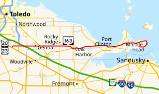
State Route 163 (SR 163) is a 46.24-mile (74.42 km) long east–west state highway in the northwestern portion of the U.S. state of Ohio. The western terminus of SR 163 is at a T-intersection with the duplex of U.S. Route 20 (US 20) and US 23 approximately 6 miles (9.7 km) southeast of the city limits of Perrysburg. Its eastern terminus is at its intersection with Hartshorn Road nearly 2 miles (3.2 km) west of the village limits of Marblehead, on the peninsula formed by Lake Erie and Sandusky Bay.

Ohio State Route 253 highway in Ohio

State Route 253 is a very short east–west state highway in the southern part of the U.S. state of Ohio. With an overall length of just 0.56 miles (0.90 km), the majority of SR 253 is a part of the Jesse Stuart Memorial Bridge, which crosses over the Ohio River near Franklin Furnace, Ohio. The western terminus of SR 253 is at about the midspan of the bridge, where it crosses the Kentucky State Line and becomes Kentucky Route 10 (KY 10). The eastern terminus of the highway is at a diamond interchange with U.S. Route 52 (US 52) near the eastern landing of the Ohio River crossing. The current SR 253 was established in the late 1980s. However, an earlier version of the highway existed in the Medina vicinity from the early 1920s until the late 1950s.

Ohio State Route 257 highway in Ohio

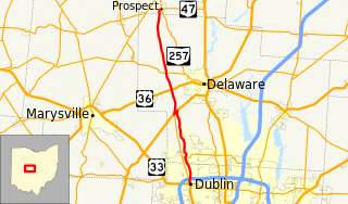
State Route 257 is a 26.19-mile (42.15 km) north - south state highway in the central portion of the U.S. state of Ohio. The highway's southern terminus is in the northwestern Columbus suburb of Dublin at a roundabout intersection with U.S. Route 33 and SR 161. This mainly two-lane highway follows the eastern side of the Scioto River from Dublin to its junction with US 42. After crossing over the river with the U.S. highway, SR 257 parallels the river's western bank. SR 257 has its northern terminus at a T-intersection with SR 47 on the western village limits of Prospect. SR 257 was created in 1926, and extended in 1935 and 1937.

Ohio State Route 329 highway in Ohio

State Route 329 is a state highway located in southeastern Ohio. The route is signed as a north–south route though the shape of the road is more of a backwards C. The southern terminus of SR 329 is in the Rome Township community of Guysville at US 50 and SR 32. After traveling north through the Athens County communities of Stewart and Amesville, the route briefly enters Morgan County before re-entering Athens County and ending at SR 13 in the village of Trimble.

Ohio State Route 202 highway in Ohio

State Route 202 (SR 202) is a 20-mile (32 km) north–south state highway in the western part of the U.S. state of Ohio. The highway runs from its southern terminus at an intersection with SR 201 in Dayton to its northern terminus at a T-intersection with SR 55 in the eastern end of Troy.

Ohio State Route 249 highway in Ohio

State Route 249 (SR 249) is an Ohio State Route that runs between the Indiana state line and Ney in the US state of Ohio. The 14.45 miles (23.26 km) of SR 249 that lie within the state serve as a minor highway. None of the highway is listed on the National Highway System. The whole route is a rural two-lane highway and passes through farmland. The highway was first signed in 1925 and was a north–south route, a route that later became U.S. Route 127 (US 127). SR 249 was given its current route in 1927, as a replacement for SR 22. The route was completely paved by 1942.

Ohio State Route 258 highway in Ohio

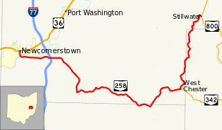
State Route 258 is a state highway that runs 25.64 miles (41.26 km) in eastern Ohio. It travels from US 36 in Newcomerstown to SR 800 in Rush Township community of Stillwater. Most of the route is in Tuscarawas County but the route briefly enters Guernsey and Harrison Counties.

Ohio State Route 259 highway in Ohio

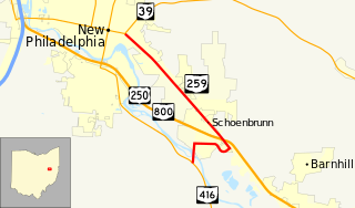
State Route 259 is a 4.41-mile (7.10 km) long state highway in central Tuscarawas County, Ohio. The route runs from its eastern terminus at SR 416 in Goshen Township to its western terminus at SR 39 in New Philadelphia.

Ohio State Route 276

State Route 276 is a 6.46-mile (10.40 km) long state highway located entirely in Clermont County, Ohio. The route runs from an intersection with West Main Street and 5th Street in Williamsburg to US 50 and SR 132 in Owensville.

Ohio State Route 285

State Route 285 is a 28.03-mile (45.11 km) long state highway in eastern Ohio. The route runs from SR 821 in Caldwell, Ohio, the county seat of Noble County, to US 22 in Madison Township, Guernsey County.

Ohio State Route 296

State Route 296 is a 10.54-mile (16.96 km) long state highway entirely in Champaign County, Ohio. Routed around the northern side of Urbana, the route runs in two townships, Salem Township and Wayne Township.

Ohio State Route 321

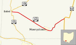
State Route 321 is a short 9.07-mile (14.60 km) long state highway in southwestern Highland County, Ohio. The route connects SR 134 in Buford and US 62 with the village of Mowrystown.

Ohio State Route 340

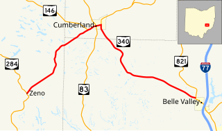
State Route 340 is a 13.2-mile-long (21.2 km) state highway in eastern Ohio. The route runs from its western terminus at SR 284 in the Meigs Township community of Zeno to its eastern terminus at SR 821 in the northwestern corner of Belle Valley.

Ohio State Route 342

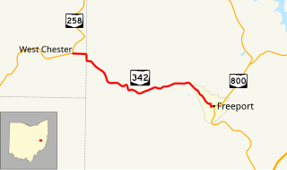
State Route 342 is a 5.27-mile-long (8.48 km) state highway in eastern Ohio. The short route connects SR 258 in the Perry Township community of West Chester to SR 800 in the village of Freeport.

Ohio State Route 356

State Route 356 is a 10.74-mile-long (17.28 km) state highway in southeastern Ohio. The route connects US 50 in the Knox Township, Vinton County community of Bolins Mills to SR 56 in Waterloo Township, Athens County.

Ohio State Route 361

State Route 361 is a 4.67-mile-long (7.52 km) long state highway entirely located within Pickaway Township, Pickaway County, Ohio. The route connects US 23 with SR 159 just north of Kingston.

Ohio State Route 529

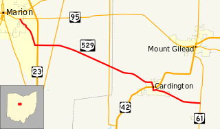
State Route 529 is a 17.62-mile-long (28.36 km) state highway in Marion and Morrow Counties, Ohio. The route connects the city of Marion at SR 95 to SR 61 just north of the village of Fulton by way of Cardington.

Ohio State Route 541

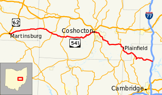
State Route 541 is a 52.28-mile-long (84.14 km) state highway in central Ohio. The route's western terminus is US 62 in Martinsburg and its eastern terminus is at exit 54 of I-77 in Liberty Township.

Ohio State Route 756

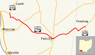
State Route 756 is a 13.16-mile-long (21.18 km) state highway in southwestern Ohio. Located in the southern portions of Clermont and Brown Counties, it runs from SR 232 in Monroe Township to SR 505 in Lewis Township. The east–west route passes through downtown Felicity.

Ohio State Route 771

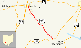
State Route 771 is a 7.11-mile-long (11.44 km) state highway located entirely in Highland County, Ohio. The north–south route connects SR 138 in Paint Township and SR 28 in Leesburg.

References

  1. 1 2 3 "DESTAPE - Jefferson County" (PDF). Ohio Department of Transportation. June 24, 2015. Retrieved January 3, 2016.
  2. National Highway System: Ohio (PDF) (Map). Federal Highway Administration. October 2012. Retrieved 2013-08-19.
  3. Google (January 3, 2016). "Overview of southern SR 152 segment" (Map). Google Maps . Google. Retrieved January 3, 2016.
  4. 1 2 Google (January 3, 2016). "Overview of northern SR 152 segment" (Map). Google Maps . Google. Retrieved January 3, 2016.
  5. Map of Ohio Showing State Routes (MrSID) (Map). Cartography by ODHPW. Ohio Department of Highways and Public Works. 1922. Retrieved 2013-08-18.
  6. 1 2 Map of Ohio Showing State Routes (MrSID) (Map). Cartography by ODHPW. Ohio Department of Highways and Public Works. 1923. Retrieved 2013-08-18.
  7. Map of Ohio Showing State Routes (MrSID) (Map). Cartography by ODHPW. Ohio Department of Highways and Public Works. 1916. Retrieved 2013-08-18.
  8. Map of Ohio Showing State Routes (MrSID) (Map). Cartography by ODHPW. Ohio Department of Highways and Public Works. 1931. Retrieved 2013-08-19.
  9. Map of Ohio Showing State Routes (MrSID) (Map). Cartography by ODHPW. Ohio Department of Highways and Public Works. 1932. Retrieved 2013-08-19.
  10. Map of Ohio Showing State Routes (MrSID) (Map). Cartography by ODHPW. Ohio Department of Highways and Public Works. 1936. Retrieved 2013-08-19.
  11. Map of Ohio Showing State Routes (MrSID) (Map). Cartography by ODHPW. Ohio Department of Highways and Public Works. 1937. Retrieved 2013-08-19.
  12. Map of Ohio Showing State Routes (MrSID) (Map). Cartography by ODHPW. Ohio Department of Highways and Public Works. 1938. Retrieved 2013-08-19.
  13. Map of Ohio Showing State Routes (MrSID) (Map). Cartography by ODHPW. Ohio Department of Highways and Public Works. 1942. Retrieved 2013-08-19.
  14. Map of Ohio Showing State Routes (MrSID) (Map). Cartography by ODHPW. Ohio Department of Highways and Public Works. 1944. Retrieved 2013-08-19.
  15. 1969 Official Ohio Highway Map (MrSID) (Map). Cartography by P.E. Masheter, Director. ODOH. 1969. Retrieved September 22, 2013.
  16. 1971 Ohio Highway Map (MrSID) (Map). Cartography by J. Phillip Richley, Director. ODOH. 1971. Retrieved August 19, 2013.

Route map: Google

KML file (edithelp)
KML is from Wikidata