National Register of Historic Places listings in Jefferson County, Ohio

Last updated

Location of Jefferson County in Ohio Map of Ohio highlighting Jefferson County.svg
Location of Jefferson County in Ohio

This is a list of the National Register of Historic Places listings in Jefferson County, Ohio.

Contents

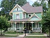
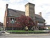
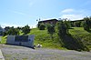
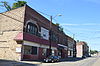
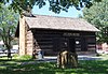
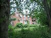
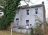
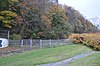
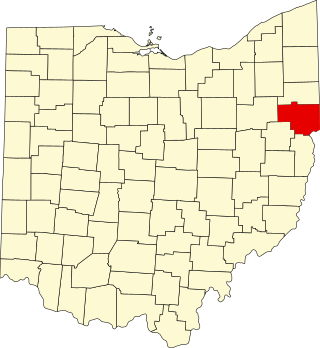
This is intended to be a complete list of the properties on the National Register of Historic Places in Jefferson County, Ohio, United States. The locations of National Register properties for which the latitude and longitude coordinates are included below, may be seen in a Google map. [1]

There are 25 properties and districts listed on the National Register in the county, including two National Historic Landmarks. Another two properties were once listed but have been removed.


    This National Park Service list is complete through NPS recent listings posted December 15, 2023. [2]

Map all coordinates using: OpenStreetMap

Current listings

[3] Name on the Register [4] ImageDate listed [5] Location City or townDescription
1 Bantam Ridge School
Bantam Ridge School Bantam Ridge School 2012-07-13.jpg
Bantam Ridge School
October 1, 1981
(#81000442)
Bantam Ridge Rd., southwest of Wintersville
40°21′34″N80°43′52″W / 40.359444°N 80.731111°W / 40.359444; -80.731111 (Bantam Ridge School)
Cross Creek Township
2 Ann E. Lewis Bernhard House
Ann E. Lewis Bernhard House Ann E. Lewis Bernhard House 2012-07-13.JPG
Ann E. Lewis Bernhard House
April 28, 2005
(#05000342)
42 E. Main St.
40°13′06″N80°52′20″W / 40.218333°N 80.872222°W / 40.218333; -80.872222 (Ann E. Lewis Bernhard House)
Adena
3 Carnegie Library of Steubenville
Carnegie Library of Steubenville Steubenville Carnegie library.jpg
Carnegie Library of Steubenville
September 16, 1992
(#92001160)
407 S. 4th St.
40°21′19″N80°37′06″W / 40.355278°N 80.618333°W / 40.355278; -80.618333 (Carnegie Library of Steubenville)
Steubenville
4 Central High School
Central High School Central High School (Mingo Junction, Ohio) 2012-07-13.JPG
Central High School
March 17, 1987
(#87000471)
110 Steuben Ave.
40°19′11″N80°36′31″W / 40.319722°N 80.60848°W / 40.319722; -80.60848 (Central High School)
Mingo Junction
5 Central Public School
Central Public School Central Public School site in Mingo Junction.jpg
Central Public School
March 17, 1987
(#87000472)
109 Saint Clair Ave.
40°19′09″N80°36′29″W / 40.319167°N 80.608056°W / 40.319167; -80.608056 (Central Public School)
Mingo Junction
6 Commercial Street Historic District
Commercial Street Historic District Commercial Street in Mingo Junction.jpg
Commercial Street Historic District
March 17, 1987
(#87000468)
Roughly Commercial St. between McLister and Highland Aves., May, and railroad tracks
40°19′14″N80°36′24″W / 40.320556°N 80.606667°W / 40.320556; -80.606667 (Commercial Street Historic District)
Mingo Junction
7 Federal Land Office
Federal Land Office Steubenville Land Office 2010-08-30.JPG
Federal Land Office
April 3, 1973
(#73001482)
Corner of 3rd and Adams St.
40°21′29″N80°36′51″W / 40.358056°N 80.614167°W / 40.358056; -80.614167 (Federal Land Office)
Steubenville Moved onto grounds of Fort Steuben
8 First Methodist Episcopal-Holy Trinity Greek Orthodox Church
First Methodist Episcopal-Holy Trinity Greek Orthodox Church Holy Trinity Orthodox Church in Steubenville.jpg
First Methodist Episcopal-Holy Trinity Greek Orthodox Church
March 2, 2006
(#06000093)
300 S. 4th St.
40°21′23″N80°37′00″W / 40.356389°N 80.616667°W / 40.356389; -80.616667 (First Methodist Episcopal-Holy Trinity Greek Orthodox Church)
Steubenville
9 Friends Meetinghouse
Friends Meetinghouse Friends Meetinghouse, Mount Pleasant.jpg
Friends Meetinghouse
November 10, 1970
(#70000504)
Near State Route 150
40°10′25″N80°48′10″W / 40.173611°N 80.802778°W / 40.173611; -80.802778 (Friends Meetinghouse)
Mount Pleasant
10 Hamilton-Ickes House
Hamilton-Ickes House Hamilton-Ickes House 2012-07-13.JPG
Hamilton-Ickes House
November 26, 1980
(#80003106)
North of Adena on State Route 10
40°13′47″N80°52′00″W / 40.229722°N 80.866667°W / 40.229722; -80.866667 (Hamilton-Ickes House)
Smithfield Township
11 Hodgen's Cemetery Mound
Hodgen's Cemetery Mound Hodgen's Cemetery Mound from the east.jpg
Hodgen's Cemetery Mound
September 25, 1975
(#75001443)
In Hodgen's Cemetery, off Walden Ave. [6] [7]
40°10′28″N80°41′41″W / 40.174444°N 80.694722°W / 40.174444; -80.694722 (Hodgen's Cemetery Mound)
Tiltonsville
12 Independent School District No. 2 Building
Independent School District No. 2 Building Independent School District No. 2 Building 2012-07-13.JPG
Independent School District No. 2 Building
July 10, 1986
(#86001569)
64520 State Route 213, north of Steubenville
40°25′05″N80°39′26″W / 40.418056°N 80.657222°W / 40.418056; -80.657222 (Independent School District No. 2 Building)
Island Creek Township
13 Benjamin Lundy House
Benjamin Lundy House Benjamin Lundy House.jpg
Benjamin Lundy House
May 30, 1974
(#74001537)
Union and Market Sts.
40°10′29″N80°48′13″W / 40.17483°N 80.80354°W / 40.17483; -80.80354 (Benjamin Lundy House)
Mount Pleasant
14 Market Street Bridge
Market Street Bridge Ohio - Steubenville 2.jpg
Market Street Bridge
March 21, 2019
(#100003517)
West Virginia Route 2 spur and Market Street
40°21′32″N80°36′41″W / 40.358889°N 80.611389°W / 40.358889; -80.611389 (Market Street Bridge)
Steubenville Extends into Brooke County, West Virginia
15 Market Street Section, Retaining Wall and Water Trough
Market Street Section, Retaining Wall and Water Trough Market Street Section in Steubenville.jpg
Market Street Section, Retaining Wall and Water Trough
October 8, 1992
(#92001353)
Old Market St. between Market St. off ramp and Lawson Ave.
40°21′47″N80°37′26″W / 40.363056°N 80.623889°W / 40.363056; -80.623889 (Market Street Section, Retaining Wall and Water Trough)
Steubenville
16 Mount Pleasant Historic District
Mount Pleasant Historic District Mount Pleasant Historic Site.jpg
Mount Pleasant Historic District
June 28, 1974
(#74001536)
Roughly bounded by Union Street alleys, Cemetery St., and Market St.
40°10′28″N80°47′55″W / 40.174444°N 80.798611°W / 40.174444; -80.798611 (Mount Pleasant Historic District)
Mount Pleasant
17 North End Neighborhood Historic District
North End Neighborhood Historic District Fourth and Madison in Steubenville.jpg
North End Neighborhood Historic District
October 1, 1991
(#91001486)
Roughly N. 4th St. from Dock St. to Franklin Ave. and the eastern side of the junction of Franklin and N. 5th St.
40°22′09″N80°36′37″W / 40.369167°N 80.610278°W / 40.369167; -80.610278 (North End Neighborhood Historic District)
Steubenville
18 North Hill Historic District
North Hill Historic District Logan near Warren in Mingo Junction.jpg
North Hill Historic District
March 17, 1987
(#87000469)
Bounded by Logan, George, Western, and alley west of Logan Ave.
40°19′36″N80°36′34″W / 40.326667°N 80.609444°W / 40.326667; -80.609444 (North Hill Historic District)
Mingo Junction
19 Speedway Mound
Speedway Mound Speedway Mound from road.jpg
Speedway Mound
September 5, 1975
(#75001444)
Old State Route 7 at Warrenton [8]
40°11′29″N80°40′35″W / 40.191389°N 80.676389°W / 40.191389; -80.676389 (Speedway Mound)
Warren Township Located above the speedway in Warrenton [6]
20 Steubenville Commercial Historic District
Steubenville Commercial Historic District Jefferson County Courthouse in Steubenville.jpg
Steubenville Commercial Historic District
August 21, 1986
(#86001877)
Roughly bounded by Washington, Court and 3rd, Market, and 8th and Commercial Sts.
40°21′38″N80°36′54″W / 40.360556°N 80.615°W / 40.360556; -80.615 (Steubenville Commercial Historic District)
Steubenville
21 Steubenville Pottery Company Buildings
Steubenville Pottery Company Buildings Steubenville Pottery Company Buildings.jpg
Steubenville Pottery Company Buildings
July 31, 1995
(#92001034)
County Road 44 southwest of its junction with State Route 7, north of Steubenville
40°24′04″N80°37′24″W / 40.401111°N 80.623333°W / 40.401111; -80.623333 (Steubenville Pottery Company Buildings)
Island Creek Township
22 Steubenville YMCA Building
Steubenville YMCA Building Steubenville YMCA Building 2012-07-13.JPG
Steubenville YMCA Building
June 1, 1982
(#82003601)
214 N. 4th St.
40°21′44″N80°36′51″W / 40.362222°N 80.614167°W / 40.362222; -80.614167 (Steubenville YMCA Building)
Steubenville
23 Stringer Stone House
Stringer Stone House Stringer Stone House site.jpg
Stringer Stone House
July 10, 1974
(#74001538)
224 Main St., corner of Main and Warren St.
40°11′16″N80°41′20″W / 40.187777°N 80.68888°W / 40.187777; -80.68888 (Stringer Stone House)
Rayland
24 Toronto World War I Monument
Toronto World War I Monument Toronto World War I Monument, comprehensive closeup.jpg
Toronto World War I Monument
October 7, 2004
(#04001116)
208 Market St. at 3rd St.
40°27′56″N80°35′59″W / 40.465556°N 80.599722°W / 40.465556; -80.599722 (Toronto World War I Monument)
Toronto
25 Union Cemetery-Beatty Park
Union Cemetery-Beatty Park Civil War Memorial-Union Cemetery, Steubenville 2012-07-13.JPG
Union Cemetery-Beatty Park
February 27, 1987
(#86003507)
1720 W. Market St. and Lincoln Ave.
40°22′06″N80°37′59″W / 40.3683333°N 80.6330555°W / 40.3683333; -80.6330555 (Union Cemetery-Beatty Park)
Steubenville

Former listings

[3] Name on the RegisterImageDate listedDate removedLocationCity or townDescription
1 Ohio Valley Clay Company
Ohio Valley Clay Company Ohio Valley Clay Company 1910.jpg
Ohio Valley Clay Company
August 10, 1979
(#79001868)
January 31, 1995Washington and Water Sts
40°21′38″N80°36′41″W / 40.3606°N 80.6114°W / 40.3606; -80.6114 (Ohio Valley Clay Company)
Steubenville
2 Smithfield School
Smithfield School Smithfield School 1910.jpg
Smithfield School
October 16, 1981
(#81000440)
May 5, 1983High St.
Smithfield

See also

Related Research Articles

<span class="mw-page-title-main">National Register of Historic Places listings in Columbiana County, Ohio</span>

This is a list of the National Register of Historic Places listings in Columbiana County, Ohio.

<span class="mw-page-title-main">National Register of Historic Places listings in Ashtabula County, Ohio</span>

This is a list of the National Register of Historic Places listings in Ashtabula County, Ohio.

<span class="mw-page-title-main">National Register of Historic Places listings in Greene County, Ohio</span>

This is a list of the National Register of Historic Places listings in Greene County, Ohio.

<span class="mw-page-title-main">National Register of Historic Places listings in Washington County, Ohio</span>

This is a list of the National Register of Historic Places listings in Washington County, Ohio.

<span class="mw-page-title-main">National Register of Historic Places listings in Scioto County, Ohio</span>

This is a list of the National Register of Historic Places listings in Scioto County, Ohio.

<span class="mw-page-title-main">National Register of Historic Places listings in Athens County, Ohio</span>

This is a list of the National Register of Historic Places listings in Athens County, Ohio.

<span class="mw-page-title-main">National Register of Historic Places listings in Belmont County, Ohio</span>

This is a list of the National Register of Historic Places listings in Belmont County, Ohio.

<span class="mw-page-title-main">National Register of Historic Places listings in Jefferson County, Pennsylvania</span>

This is a list of the National Register of Historic Places listings in Jefferson County, Pennsylvania.

<span class="mw-page-title-main">National Register of Historic Places listings in Lawrence County, Ohio</span>

This is a list of the National Register of Historic Places listings in Lawrence County, Ohio.

<span class="mw-page-title-main">National Register of Historic Places listings in Marion County, Ohio</span>

This is a list of the National Register of Historic Places listings in Marion County, Ohio.

<span class="mw-page-title-main">National Register of Historic Places listings in Clark County, Indiana</span>

This is a list of the National Register of Historic Places listings in Clark County, Indiana.

<span class="mw-page-title-main">National Register of Historic Places listings in Ripley County, Indiana</span>

This is a list of the National Register of Historic Places listings in Ripley County, Indiana.

<span class="mw-page-title-main">National Register of Historic Places listings in Switzerland County, Indiana</span>

This is a list of the National Register of Historic Places listings in Switzerland County, Indiana.

<span class="mw-page-title-main">National Register of Historic Places listings in Carroll County, Ohio</span>

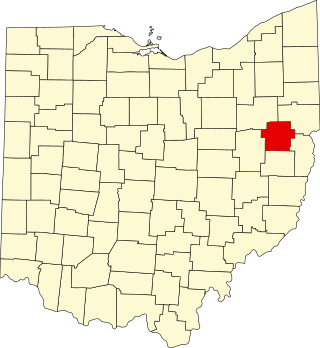
This is a list of the National Register of Historic Places listings in Carroll County, Ohio.

<span class="mw-page-title-main">National Register of Historic Places listings in Monroe County, Ohio</span>

This is a list of the National Register of Historic Places listings in Monroe County, Ohio.

<span class="mw-page-title-main">National Register of Historic Places listings in Meigs County, Ohio</span>

This is a list of the National Register of Historic Places listings in Meigs County, Ohio.

<span class="mw-page-title-main">National Register of Historic Places listings in Gallia County, Ohio</span>

This is a list of the National Register of Historic Places listings in Gallia County, Ohio.

<span class="mw-page-title-main">National Register of Historic Places listings in Harrison County, Ohio</span>

This is a list of the National Register of Historic Places listings in Harrison County, Ohio.

<span class="mw-page-title-main">National Register of Historic Places listings in Paulding County, Ohio</span>

This is a list of the National Register of Historic Places listings in Paulding County, Ohio.

<span class="mw-page-title-main">National Register of Historic Places listings in Pike County, Ohio</span>

This is a list of the National Register of Historic Places listings in Pike County, Ohio.

References

  1. The latitude and longitude information provided in this table was derived originally from the National Register Information System, which has been found to be fairly accurate for about 99% of listings. Some locations in this table may have been corrected to current GPS standards.
  2. National Park Service, United States Department of the Interior, "National Register of Historic Places: Weekly List Actions", retrieved December 15, 2023.
  3. 1 2 Numbers represent an alphabetical ordering by significant words. Various colorings, defined here, differentiate National Historic Landmarks and historic districts from other NRHP buildings, structures, sites or objects.
  4. "National Register Information System". National Register of Historic Places . National Park Service. April 24, 2008.
  5. The eight-digit number below each date is the number assigned to each location in the National Register Information System database, which can be viewed by clicking the number.
  6. 1 2 Location derived from Jefferson County, Governor's Office of Appalachia. Accessed 2009-09-11. The NRIS lists the site as "Address Restricted".
  7. Coordinates derived from the GNIS feature record for the cemetery
  8. U.S. Geological Survey Geographic Names Information System: Debo Park Speedway (historical)