National Register of Historic Places listings in Wood County, Ohio

Last updated

Location of Wood County in Ohio Map of Ohio highlighting Wood County.svg
Location of Wood County in Ohio

This is a list of the National Register of Historic Places listings in Wood County, Ohio.

Contents

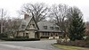
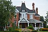
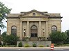
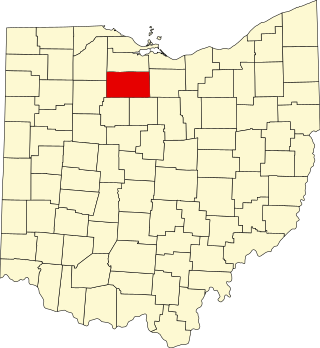
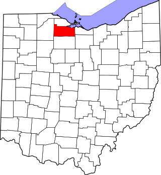
This is intended to be a complete list of the properties and districts on the National Register of Historic Places in Wood County, Ohio, United States. The locations of National Register properties and districts for which the latitude and longitude coordinates are included below, may be seen in an online map. [1]

There are 33 properties and districts listed on the National Register in the county, including 1 National Historic Landmark.


    This National Park Service list is complete through NPS recent listings posted January 20, 2023. [2]

Map all coordinates using: OpenStreetMap  
Download coordinates as: KML

Current listings

[3] Name on the Register [4] ImageDate listed [5] Location City or townDescription
1 Boom Town Historic District
Boom Town Historic District Wooster Street in Boom Town.jpg
Boom Town Historic District
May 8, 1987
(#87000693)
Roughly bounded by W. Wooster, S. Church, N. Grove, N. Maple, and Buttonwood
41°22′24″N83°39′20″W / 41.373333°N 83.655556°W / 41.373333; -83.655556 (Boom Town Historic District)
Bowling Green
2 Dodge Site
Dodge Site Driveway at the Dodge Site.jpg
Dodge Site
March 29, 1978
(#78002214)
17090 W. River Rd., north of Bowling Green [6]
41°29′00″N83°43′46″W / 41.483333°N 83.729444°W / 41.483333; -83.729444 (Dodge Site)
Middleton Township
3 Eagle Point Colony Historic District
Eagle Point Colony Historic District Eagle Point Colony gateway.jpg
Eagle Point Colony Historic District
September 22, 1983
(#83002068)
Colony Rd., Riverside, Eagle Point, Park, and Forest Drs.
41°36′35″N83°34′09″W / 41.609722°N 83.569167°W / 41.609722; -83.569167 (Eagle Point Colony Historic District)
Rossford
4 East River Road Historic District I
East River Road Historic District I Morningside and River near Perrysburg.jpg
East River Road Historic District I
November 21, 1976
(#76001551)
29455-30465 E. River Rd. (northern side only), southwest of Rossford
41°35′11″N83°35′27″W / 41.586389°N 83.590833°W / 41.586389; -83.590833 (East River Road Historic District I)
Perrysburg Township
5 East River Road Historic District II
East River Road Historic District II 577 Front in Perrysburg.jpg
East River Road Historic District II
November 21, 1976
(#76001550)
577 E. Front St. to 28589 E. River Rd.
41°34′00″N83°37′05″W / 41.566667°N 83.618056°W / 41.566667; -83.618056 (East River Road Historic District II)
Perrysburg and Perrysburg Township
6 Empire House
Empire House Empire House in Stony Ridge.jpg
Empire House
November 28, 1978
(#78002216)
5535 U.S. Route 20, east of Stony Ridge
41°30′29″N83°30′11″W / 41.507917°N 83.503194°W / 41.507917; -83.503194 (Empire House)
Troy Township
7 Floral Hall
Floral Hall Floral Hall in Bowling Green.jpg
Floral Hall
July 27, 1982
(#82003666)
City Park on Conneaut Ave.
41°22′49″N83°39′32″W / 41.380139°N 83.658889°W / 41.380139; -83.658889 (Floral Hall)
Bowling Green
8 Edward Ford Plate Glass Company Employee Relations Building
Edward Ford Plate Glass Company Employee Relations Building Edward Ford Plate Glass Company Employee Relations Building.jpg
Edward Ford Plate Glass Company Employee Relations Building
August 15, 2016
(#16000600)
140 Dixie Highway
41°36′52″N83°33′13″W / 41.614444°N 83.553611°W / 41.614444; -83.553611 (Edward Ford Plate Glass Company Employee Relations Building)
Rossford
9 Fort Meigs
Fort Meigs Fort Meigs 04.jpg
Fort Meigs
August 4, 1969
(#69000151)
1.3 mi (2.1 km) southwest of Perrysburg
41°33′10″N83°39′06″W / 41.552778°N 83.651667°W / 41.552778; -83.651667 (Fort Meigs)
Perrysburg
10 Fort Meigs Aboriginal-33WO08-33WO445
Fort Meigs Aboriginal-33WO08-33WO445 Fort Meigs 06.jpg
Fort Meigs Aboriginal-33WO08-33WO445
February 12, 1998
(#98000042)
1.3 mi (2.1 km) southwest of Perrysburg
41°33′10″N83°39′04″W / 41.552778°N 83.651111°W / 41.552778; -83.651111 (Fort Meigs Aboriginal-33WO08-33WO445)
Perrysburg
11 William Graham House
William Graham House William Graham Farmhouse.jpg
William Graham House
March 1, 1984
(#84003812)
7056 Jerry City Rd., southwest of Wayne
41°15′17″N83°32′18″W / 41.254722°N 83.538333°W / 41.254722; -83.538333 (William Graham House)
Portage Township
12 Heeter-Russo House
Heeter-Russo House Heeter-Russo House.jpg
Heeter-Russo House
May 29, 1975
(#75001554)
24570 2nd St.
41°24′38″N83°52′25″W / 41.410417°N 83.873611°W / 41.410417; -83.873611 (Heeter-Russo House)
Grand Rapids
13 Hood-Simmons House
Hood-Simmons House Hood-Simmons House.jpg
Hood-Simmons House
December 30, 1974
(#74001652)
202 W. 5th St.
41°33′17″N83°37′46″W / 41.554861°N 83.629444°W / 41.554861; -83.629444 (Hood-Simmons House)
Perrysburg
14 R.A. Housley House
R.A. Housley House R.A. Housley House.jpg
R.A. Housley House
August 22, 1996
(#96000932)
24155 Front St.
41°24′45″N83°51′56″W / 41.412500°N 83.865556°W / 41.412500; -83.865556 (R.A. Housley House)
Grand Rapids
15 Indian Hills Site
Indian Hills Site Indian Hills Site from Wales Road.jpg
Indian Hills Site
September 20, 1979
(#79001983)
Atop a promontory above the final bend of Grassy Creek, east of its confluence with the Maumee River [7]
41°36′24″N83°33′12″W / 41.606667°N 83.553333°W / 41.606667; -83.553333 (Indian Hills Site)
Rossford
16 Interurban Bridge
Interurban Bridge Farnsworth Metropark.jpg
Interurban Bridge
June 19, 1972
(#72001036)
1 mi (1.6 km) south of Waterville over the Maumee River
41°29′11″N83°43′42″W / 41.486389°N 83.728333°W / 41.486389; -83.728333 (Interurban Bridge)
Middleton Township Extends into Lucas County
17 Benjamin F. Kerr House
Benjamin F. Kerr House Benjamin F. Kerr House.jpg
Benjamin F. Kerr House
December 21, 1979
(#79001982)
17605 Beaver St.
41°24′38″N83°52′06″W / 41.410417°N 83.868333°W / 41.410417; -83.868333 (Benjamin F. Kerr House)
Grand Rapids
18 MacNichol Site
MacNichol Site MacNichol Site from River Road.jpg
MacNichol Site
November 24, 1978
(#78002215)
Southwest of Perrysburg along the Maumee River [8]
41°32′53″N83°40′02″W / 41.548056°N 83.667222°W / 41.548056; -83.667222 (MacNichol Site)
Perrysburg Township
19 Main Street Historic District
Main Street Historic District Bowling Green Ohio Main Street.jpg
Main Street Historic District
November 28, 1980
(#80003247)
Main and Wooster Sts.
41°22′30″N83°39′02″W / 41.375°N 83.650556°W / 41.375; -83.650556 (Main Street Historic District)
Bowling Green
20 North Baltimore Town Hall
North Baltimore Town Hall North Baltimore Town Hall.jpg
North Baltimore Town Hall
October 29, 1981
(#81000453)
207 North Main St.
41°10′59″N83°40′43″W / 41.183056°N 83.678611°W / 41.183056; -83.678611 (North Baltimore Town Hall)
North Baltimore Destroyed in 1985 [9]
21 Old Wood County Jail
Old Wood County Jail Old Wood County Jail.jpg
Old Wood County Jail
December 17, 1969
(#69000152)
240 W. Indiana Ave.
41°33′20″N83°37′54″W / 41.555417°N 83.631528°W / 41.555417; -83.631528 (Old Wood County Jail)
Perrysburg
22 Perrysburg Historic District
Perrysburg Historic District Louisiana Avenue in downtown Perrysburg.jpg
Perrysburg Historic District
April 14, 1975
(#75001557)
Front St. between E. Boundary St. and W. Boundary Ln., 2nd St. between Pine and Hickory Sts., and 3rd St. at Louisiana Ave.; also roughly the Maumee River frontage from Pine to E. Boundary and the southern side of E. 2nd St. from Locust to Hickory
41°33′36″N83°37′48″W / 41.560000°N 83.630000°W / 41.560000; -83.630000 (Perrysburg Historic District)
Perrysburg Second set of addresses represents a boundary increase of June 21, 1990
23 Perrysburg Water Maintenance Building
Perrysburg Water Maintenance Building Perrysburg Water Maintenance Building.jpg
Perrysburg Water Maintenance Building
May 10, 1990
(#90000754)
130 W. Indiana Ave.
41°33′21″N83°37′44″W / 41.555833°N 83.628889°W / 41.555833; -83.628889 (Perrysburg Water Maintenance Building)
Perrysburg
24 Risingsun Town Hall and Opera House
Risingsun Town Hall and Opera House Risingsun village hall.jpg
Risingsun Town Hall and Opera House
February 18, 2021
(#100006150)
420 Main St.
41°16′07″N83°25′30″W / 41.2686°N 83.4251°W / 41.2686; -83.4251 (Risingsun Town Hall and Opera House)
Risingsun
25 Schaller Memorial Building
Schaller Memorial Building Schaller Memorial Building.jpg
Schaller Memorial Building
May 10, 1990
(#90000753)
130 W. Indiana Ave.
41°33′20″N83°37′44″W / 41.555611°N 83.628889°W / 41.555611; -83.628889 (Schaller Memorial Building)
Perrysburg
26 Edwin H. Simmons House
Edwin H. Simmons House Edwin H. Simmons House.jpg
Edwin H. Simmons House
February 7, 1991
(#90002211)
10302 Fremont Pike, southeast of Perrysburg
41°32′45″N83°35′31″W / 41.545972°N 83.591944°W / 41.545972; -83.591944 (Edwin H. Simmons House)
Perrysburg Township
27 Spafford House
Spafford House Spafford House.jpg
Spafford House
July 15, 1974
(#74001653)
27338 W. River Rd.
41°32′57″N83°39′25″W / 41.549028°N 83.656806°W / 41.549028; -83.656806 (Spafford House)
Perrysburg
28 Thurston Building
Thurston Building Thurston Building.jpg
Thurston Building
May 29, 1975
(#75001555)
Front St.
41°24′52″N83°52′04″W / 41.414444°N 83.867778°W / 41.414444; -83.867778 (Thurston Building)
Grand Rapids
29 Town Hall
Town Hall Grand Rapids Town Hall.jpg
Town Hall
May 27, 1975
(#75001556)
Front St.
41°24′44″N83°52′10″W / 41.412222°N 83.869444°W / 41.412222; -83.869444 (Town Hall)
Grand Rapids
30 U.S. Post Office
U.S. Post Office Former post office in Bowling Green.jpg
U.S. Post Office
March 28, 1979
(#79001980)
305 N. Main St.
41°22′38″N83°39′06″W / 41.377222°N 83.651667°W / 41.377222; -83.651667 (U.S. Post Office)
Bowling Green
31 Wood County Courthouse and Jail
Wood County Courthouse and Jail Wood County Courthouse Jail.jpg
Wood County Courthouse and Jail
June 25, 1974
(#74001651)
200 E. Court St.
41°22′35″N83°38′54″W / 41.376389°N 83.648333°W / 41.376389; -83.648333 (Wood County Courthouse and Jail)
Bowling Green
32 Wood County Home and Infirmary
Wood County Home and Infirmary Wood County Home and Infirmary.jpg
Wood County Home and Infirmary
April 16, 1979
(#79001981)
Southeast of Bowling Green at 13660 County Home Rd.
41°21′02″N83°37′01″W / 41.350556°N 83.616944°W / 41.350556; -83.616944 (Wood County Home and Infirmary)
Portage Township
33 John J. Yeager House
John J. Yeager House John J. Yeager House.jpg
John J. Yeager House
March 19, 1985
(#85000619)
343 W. Indiana Ave.
41°33′19″N83°38′02″W / 41.555139°N 83.633889°W / 41.555139; -83.633889 (John J. Yeager House)
Perrysburg

See also

Related Research Articles

<span class="mw-page-title-main">National Register of Historic Places listings in Cuyahoga County, Ohio</span>

This is a list of the National Register of Historic Places listings in Cuyahoga County, Ohio.

<span class="mw-page-title-main">National Register of Historic Places listings in Lucas County, Ohio</span>

This is a list of the National Register of Historic Places listings in Lucas County, Ohio.

<span class="mw-page-title-main">National Register of Historic Places listings in Montgomery County, Ohio</span>

This is a list of the National Register of Historic Places listings in Montgomery County, Ohio.

<span class="mw-page-title-main">National Register of Historic Places listings in Warren County, Ohio</span>

This is a list of the National Register of Historic Places listings in Warren County, Ohio.

<span class="mw-page-title-main">National Register of Historic Places listings in Seneca County, Ohio</span>

This is a list of the National Register of Historic Places listings in Seneca County, Ohio.

<span class="mw-page-title-main">National Register of Historic Places listings in Greene County, Ohio</span>

This is a list of the National Register of Historic Places listings in Greene County, Ohio.

<span class="mw-page-title-main">National Register of Historic Places listings in Washington County, Ohio</span>

This is a list of the National Register of Historic Places listings in Washington County, Ohio.

<span class="mw-page-title-main">National Register of Historic Places listings in Athens County, Ohio</span>

This is a list of the National Register of Historic Places listings in Athens County, Ohio.

<span class="mw-page-title-main">National Register of Historic Places listings in Brown County, Ohio</span>

This is a list of the National Register of Historic Places listings in Brown County, Ohio.

<span class="mw-page-title-main">National Register of Historic Places listings in Ottawa County, Ohio</span>

This is a list of the National Register of Historic Places listings in Ottawa County, Ohio.

<span class="mw-page-title-main">National Register of Historic Places listings in Shelby County, Ohio</span>

This is a list of the National Register of Historic Places listings in Shelby County, Ohio.

<span class="mw-page-title-main">National Register of Historic Places listings in Clinton County, Ohio</span>

This is a list of the National Register of Historic Places listings in Clinton County, Ohio.

<span class="mw-page-title-main">National Register of Historic Places listings in Preble County, Ohio</span>

This is a list of the National Register of Historic Places listings in Preble County, Ohio.

<span class="mw-page-title-main">National Register of Historic Places listings in Hancock County, Ohio</span>

This is a list of the National Register of Historic Places listings in Hancock County, Ohio.

<span class="mw-page-title-main">National Register of Historic Places listings in Sandusky County, Ohio</span>

This is a list of the National Register of Historic Places listings in Sandusky County, Ohio.

<span class="mw-page-title-main">National Register of Historic Places listings in Dearborn County, Indiana</span>

This is a list of the National Register of Historic Places listings in Dearborn County, Indiana.

<span class="mw-page-title-main">National Register of Historic Places listings in Putnam County, Ohio</span>

This is a list of the National Register of Historic Places listings in Putnam County, Ohio.

<span class="mw-page-title-main">National Register of Historic Places listings in Meigs County, Ohio</span>

This is a list of the National Register of Historic Places listings in Meigs County, Ohio.

<span class="mw-page-title-main">National Register of Historic Places listings in Henry County, Ohio</span>

This is a list of the National Register of Historic Places listings in Henry County, Ohio.

This is a list of the National Register of Historic Places listings in Cuyahoga Valley National Park.

References

  1. The latitude and longitude information provided in this table was derived originally from the National Register Information System, which has been found to be fairly accurate for about 99% of listings. Some locations in this table may have been corrected to current GPS standards.
  2. National Park Service, United States Department of the Interior, "National Register of Historic Places: Weekly List Actions", retrieved January 20, 2023.
  3. Numbers represent an alphabetical ordering by significant words. Various colorings, defined here, differentiate National Historic Landmarks and historic districts from other NRHP buildings, structures, sites or objects.
  4. "National Register Information System". National Register of Historic Places . National Park Service. April 24, 2008.
  5. The eight-digit number below each date is the number assigned to each location in the National Register Information System database, which can be viewed by clicking the number.
  6. Ohio Historic Preservation Office: Northwest Ohio Office - MS 817 Archived 2013-04-03 at the Wayback Machine , Bowling Green State University Libraries, n.d. Accessed 2013-01-02.
  7. Strothers, David M. "Indian Hills (33W04): A Protohistoric Assistaeronon Village in the Maumee River Valley of Northwestern Ohio". Ontario Archaeology 36 (1981): 47-56, p. 48.
  8. Strothers, David M., and G. Michael Pratt. "New Perspectives on the Late Woodland Cultures of the Western Lake Erie Region". Midcontinental Journal of Archaeology 6.1 (1981): 91-121.
  9. HISTORY - Village of North Baltimore, Village of North Baltimore, n.d. Accessed 2013-03-11.