National Register of Historic Places listings in Shelby County, Ohio

Last updated

Location of Shelby County in Ohio Map of Ohio highlighting Shelby County.svg
Location of Shelby County in Ohio

This is a list of the National Register of Historic Places listings in Shelby County, Ohio.

Contents

This is intended to be a complete list of the properties and districts on the National Register of Historic Places in Shelby County, Ohio, United States. The locations of National Register properties and districts for which the latitude and longitude coordinates are included below, may be seen in an online map. [1]

There are 20 properties and districts listed on the National Register in the county, including 1 National Historic Landmark. Another property was once listed but has been removed.


    This National Park Service list is complete through NPS recent listings posted August 26, 2022. [2]

Map all coordinates using: OpenStreetMap  
Download coordinates as: KML

Current listings

[3] Name on the Register [4] ImageDate listed [5] Location City or townDescription
1 Anna Town Hall
Anna Town Hall Anna Town Hall angle.jpg
Anna Town Hall
September 20, 1978
(#78002187)
209 W. Main St. [6]
40°23′41″N84°10′33″W / 40.394722°N 84.175833°W / 40.394722; -84.175833 (Anna Town Hall)
Anna
2 Botkins Elementary School
Botkins Elementary School Site of the Botkins Elementary School.jpg
Botkins Elementary School
July 26, 1979
(#79002851)
Main St.
40°28′08″N84°10′57″W / 40.468889°N 84.1825°W / 40.468889; -84.1825 (Botkins Elementary School)
Botkins
3 Emanuel Lutheran Church of Montra
Emanuel Lutheran Church of Montra Emanuel Lutheran Church of Montra, blue sky.jpg
Emanuel Lutheran Church of Montra
May 13, 1982
(#82003640)
Montra Rd. in Montra
40°25′54″N84°05′35″W / 40.431667°N 84.093056°W / 40.431667; -84.093056 (Emanuel Lutheran Church of Montra)
Jackson Township
4 Fulton Farm
Fulton Farm Fulton Farm closeup.jpg
Fulton Farm
May 8, 1979
(#79001947)
804 S. Brooklyn Ave.
40°16′34″N84°08′55″W / 40.276111°N 84.148611°W / 40.276111; -84.148611 (Fulton Farm)
Sidney
5 Immaculate Conception Rectory at Botkins
Immaculate Conception Rectory at Botkins Immaculate Conception Rectory at Botkins.jpg
Immaculate Conception Rectory at Botkins
July 26, 1979
(#79002876)
116 N. Mill St.
40°28′09″N84°10′28″W / 40.469167°N 84.174444°W / 40.469167; -84.174444 (Immaculate Conception Rectory at Botkins)
Botkins
6 Zenas King Bowstring Bridge November 29, 2021
(#100007183)
Benjamin Trail, Amos Lake, Tawawa Park
40°17′19″N84°07′40″W / 40.2886°N 84.1277°W / 40.2886; -84.1277 (Zenas King Bowstring Bridge)
Sidney
7 Lockington Covered Bridge
Lockington Covered Bridge Lockington Covered Bridge winter.jpg
Lockington Covered Bridge
June 10, 1975
(#75001532)
1 mile east of Lockington on State Route 132
40°12′36″N84°12′53″W / 40.21°N 84.214722°W / 40.21; -84.214722 (Lockington Covered Bridge)
Orange and Washington TownshipsBurned circa 1989 [7]
8 Lockington Locks Historical Area
Lockington Locks Historical Area First lock at Lockington from below.jpg
Lockington Locks Historical Area
December 17, 1969
(#69000147)
Miami and Erie Canal between Lockington and Washington Township
40°12′34″N84°14′38″W / 40.209444°N 84.243889°W / 40.209444; -84.243889 (Lockington Locks Historical Area)
Lockington and Washington Township Extends into Washington Township in Miami County
9 People's Federal Savings and Loan Association
People's Federal Savings and Loan Association Sidney-ohio-pfsl.jpg
People's Federal Savings and Loan Association
June 5, 1972
(#72001042)
101 E. Court St.
40°17′02″N84°09′24″W / 40.283889°N 84.156667°W / 40.283889; -84.156667 (People's Federal Savings and Loan Association)
Sidney Designed by Louis Sullivan, 1917; still an operating thrift
10 Port Jefferson School
Port Jefferson School Site of the Port Jefferson School.jpg
Port Jefferson School
June 2, 1982
(#82003641)
Wall and Spring Sts.
40°19′48″N84°05′33″W / 40.33°N 84.0925°W / 40.33; -84.0925 (Port Jefferson School)
Port Jefferson
11 Sacred Heart of Jesus Rectory
Sacred Heart of Jesus Rectory Sacred Heart of Jesus Rectory at McCartyville.jpg
Sacred Heart of Jesus Rectory
July 26, 1979
(#79002874)
State Routes 29 and 119 at McCartyville
40°23′42″N84°15′17″W / 40.395093°N 84.254609°W / 40.395093; -84.254609 (Sacred Heart of Jesus Rectory)
Van Buren Township
12 St. Michael Catholic Church Complex
St. Michael Catholic Church Complex St. Michael's Catholic Church in Fort Loramie, front and eastern side.jpg
St. Michael Catholic Church Complex
July 26, 1979
(#79002825)
State Route 705 east of State Route 66
40°21′05″N84°22′19″W / 40.351389°N 84.371944°W / 40.351389; -84.371944 (St. Michael Catholic Church Complex)
Fort Loramie
13 St. Patrick Catholic Church and Rectory
St. Patrick Catholic Church and Rectory Site of St. Patrick Catholic Church in St. Patrick, Ohio.jpg
St. Patrick Catholic Church and Rectory
July 26, 1979
(#79002836)
Hoying and Wright-Puthoff Rds. in St. Patrick
40°22′13″N84°17′19″W / 40.370278°N 84.288611°W / 40.370278; -84.288611 (St. Patrick Catholic Church and Rectory)
Van Buren Township
14 St. Remy Catholic Church
St. Remy Catholic Church St. Remy Catholic Church, Russia.jpg
St. Remy Catholic Church
July 26, 1979
(#79002834)
Main St. and Russia-Versailles Rd.
40°14′01″N84°24′53″W / 40.233522°N 84.414792°W / 40.233522; -84.414792 (St. Remy Catholic Church)
Russia
15 Shelby House
Shelby House Shelby House in Botkins.jpg
Shelby House
December 8, 1978
(#78002188)
403 W. State St.
40°28′02″N84°11′13″W / 40.467222°N 84.186944°W / 40.467222; -84.186944 (Shelby House)
Botkins
16 Sidney Courthouse Square Historic District
Sidney Courthouse Square Historic District Sidney-ohio-courthouse.jpg
Sidney Courthouse Square Historic District
September 27, 1980
(#80003232)
Roughly bounded by North and South Sts. and West and Miami Aves.
40°17′06″N84°09′21″W / 40.285°N 84.155833°W / 40.285; -84.155833 (Sidney Courthouse Square Historic District)
Sidney
17 Sidney Walnut Avenue Historic District
Sidney Walnut Avenue Historic District Sidney Walnut Avenue Historic District.jpg
Sidney Walnut Avenue Historic District
December 29, 1983
(#83004338)
Walnut Ave. from Poplar to Michigan Sts., and 228, 228½, and 238 W. North St.
40°17′12″N84°09′37″W / 40.286667°N 84.160278°W / 40.286667; -84.160278 (Sidney Walnut Avenue Historic District)
Sidney
18 Sidney Waterworks and Electric Light Building
Sidney Waterworks and Electric Light Building Sidney Waterworks and Electric Light Building.jpg
Sidney Waterworks and Electric Light Building
December 29, 1978
(#78002190)
121 N. Brooklyn Ave.
40°17′07″N84°08′56″W / 40.285347°N 84.149°W / 40.285347; -84.149 (Sidney Waterworks and Electric Light Building)
Sidney
19 Whitby Mansion
Whitby Mansion Whitby Mansion, Sidney.jpg
Whitby Mansion
December 12, 1976
(#76001526)
429 N. Ohio Ave.
40°17′26″N84°09′26″W / 40.290556°N 84.157222°W / 40.290556; -84.157222 (Whitby Mansion)
Sidney
20 Wilson-Lenox House
Wilson-Lenox House Wilson-Lenox House.jpg
Wilson-Lenox House
March 27, 1980
(#80003233)
West of Sidney at 9804 Houston Rd.
40°15′21″N84°14′55″W / 40.255833°N 84.248611°W / 40.255833; -84.248611 (Wilson-Lenox House)
Washington Township

Former listing

[3] Name on the RegisterImageDate listedDate removedLocationCity or townDescription
1 Turtle Creek Culvert and Embankment
Turtle Creek Culvert and Embankment Turtle Creek Culvert northwestern abutment.jpg
Turtle Creek Culvert and Embankment
August 10, 1978
(#78002189)
October 29, 1985West of New Bern
40°15′01″N84°14′56″W / 40.2503°N 84.2489°W / 40.2503; -84.2489 (Turtle Creek Culvert and Embankment)
New Bern

See also

Related Research Articles

<span class="mw-page-title-main">National Register of Historic Places listings in Cuyahoga County, Ohio</span>

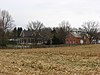
This is a list of the National Register of Historic Places listings in Cuyahoga County, Ohio.

<span class="mw-page-title-main">National Register of Historic Places listings in Lorain County, Ohio</span>

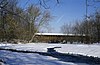
This is a list of the National Register of Historic Places listings in Lorain County, Ohio.

<span class="mw-page-title-main">National Register of Historic Places listings in Licking County, Ohio</span>

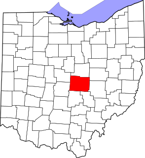
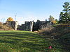
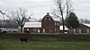
This is a list of the National Register of Historic Places listings in Licking County, Ohio.

<span class="mw-page-title-main">National Register of Historic Places listings in Champaign County, Ohio</span>

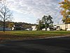
This is a list of the National Register of Historic Places listings in Champaign County, Ohio.

<span class="mw-page-title-main">National Register of Historic Places listings in Miami County, Ohio</span>

This is a list of the National Register of Historic Places listings in Miami County, Ohio.

<span class="mw-page-title-main">National Register of Historic Places listings in Auglaize County, Ohio</span>

This is a list of the National Register of Historic Places listings in Auglaize County, Ohio.

<span class="mw-page-title-main">National Register of Historic Places listings in Tuscarawas County, Ohio</span>

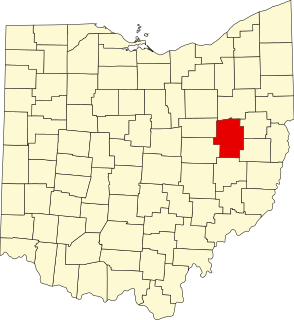
This is a list of the National Register of Historic Places listings in Tuscarawas County, Ohio.

<span class="mw-page-title-main">National Register of Historic Places listings in Darke County, Ohio</span>

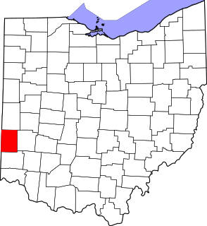
This is a list of the National Register of Historic Places listings in Darke County, Ohio.

<span class="mw-page-title-main">National Register of Historic Places listings in Mercer County, Ohio</span>

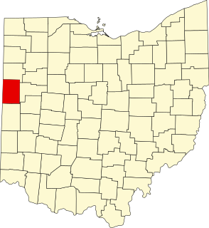
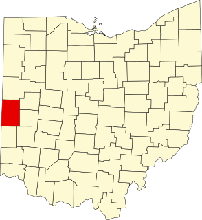
This is a list of the National Register of Historic Places listings in Mercer County, Ohio.

<span class="mw-page-title-main">National Register of Historic Places listings in Jefferson County, Ohio</span>

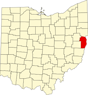
This is a list of the National Register of Historic Places listings in Jefferson County, Ohio.

<span class="mw-page-title-main">National Register of Historic Places listings in Medina County, Ohio</span>

This is a list of the National Register of Historic Places listings in Medina County, Ohio.

<span class="mw-page-title-main">National Register of Historic Places listings in Coshocton County, Ohio</span>

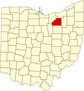
This is a list of the National Register of Historic Places listings in Coshocton County, Ohio.

<span class="mw-page-title-main">National Register of Historic Places listings in Henderson County, Kentucky</span>

This is a list of the National Register of Historic Places listings in Henderson County, Kentucky.

<span class="mw-page-title-main">National Register of Historic Places listings in Hardin County, Kentucky</span>

This is a list of the National Register of Historic Places listings in Hardin County, Kentucky.

<span class="mw-page-title-main">National Register of Historic Places listings in Montgomery County, Kentucky</span>

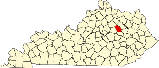
This is a list of the National Register of Historic Places listings in Montgomery County, Kentucky.

<span class="mw-page-title-main">National Register of Historic Places listings in Preble County, Ohio</span>

This is a list of the National Register of Historic Places listings in Preble County, Ohio.

<span class="mw-page-title-main">National Register of Historic Places listings in Holmes County, Ohio</span>

This is a list of the National Register of Historic Places listings in Holmes County, Ohio.

<span class="mw-page-title-main">National Register of Historic Places listings in Shelby County, Indiana</span>

This is a list of the National Register of Historic Places listings in Shelby County, Indiana.

<span class="mw-page-title-main">National Register of Historic Places listings in Logan County, Ohio</span>

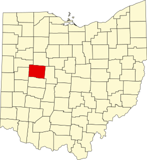
This is a list of the National Register of Historic Places listings in Logan County, Ohio.

<span class="mw-page-title-main">National Register of Historic Places listings in Union County, Ohio</span>

This is a list of the National Register of Historic Places listings in Union County, Ohio.

References

  1. The latitude and longitude information provided in this table was derived originally from the National Register Information System, which has been found to be fairly accurate for about 99% of listings. Some locations in this table may have been corrected to current GPS standards.
  2. National Park Service, United States Department of the Interior, "National Register of Historic Places: Weekly List Actions", retrieved August 26, 2022.
  3. 1 2 Numbers represent an alphabetical ordering by significant words. Various colorings, defined here, differentiate National Historic Landmarks and historic districts from other NRHP buildings, structures, sites or objects.
  4. "National Register Information System". National Register of Historic Places . National Park Service. April 24, 2008.
  5. The eight-digit number below each date is the number assigned to each location in the National Register Information System database, which can be viewed by clicking the number.
  6. Contact Us, Village of Anna. Accessed 2009-06-11.
  7. Sayre, Jim. Long-Gone Bridge Remains on National Register of Historic Places, Shelby County Ohio Historical Society, August 1998. Accessed 2009-06-11.