National Register of Historic Places listings in Preble County, Ohio

Last updated

Location of Preble County in Ohio Map of Ohio highlighting Preble County.svg
Location of Preble County in Ohio

This is a list of the National Register of Historic Places listings in Preble County, Ohio.

Contents

This is intended to be a complete list of the properties and districts on the National Register of Historic Places in Preble County, Ohio, United States. The locations of National Register properties and districts for which the latitude and longitude coordinates are included below, may be seen in a Google map. [1]

There are 19 properties and districts listed on the National Register in the county.


    This National Park Service list is complete through NPS recent listings posted December 15, 2023. [2]

Map all coordinates using: OpenStreetMap

Current listings

[3] Name on the Register [4] ImageDate listed [5] Location City or townDescription
1 Acton House
Acton House Acton House in Eaton.jpg
Acton House
September 5, 1985
(#85001944)
115 W. Main St.
39°44′38″N84°38′15″W / 39.74375°N 84.6375°W / 39.74375; -84.6375 (Acton House)
Eaton
2 Brubaker Covered Bridge
Brubaker Covered Bridge Brubaker Covered Bridge, southern side and western portal.jpg
Brubaker Covered Bridge
June 11, 1975
(#75001527)
West of Gratis on Aukerman Creek Rd.
39°39′06″N84°32′39″W / 39.651667°N 84.544167°W / 39.651667; -84.544167 (Brubaker Covered Bridge)
Gratis Township
3 Bunker Hill House
Bunker Hill House Bunker Hill House in Fairhaven.jpg
Bunker Hill House
September 28, 2001
(#01001062)
7919 State Route 177 in Fairhaven
39°38′13″N84°46′20″W / 39.636944°N 84.772222°W / 39.636944; -84.772222 (Bunker Hill House)
Dixon Township
4 Camden City Hall and Opera House
Camden City Hall and Opera House Camden City Hall -- Camden, Ohio.jpg
Camden City Hall and Opera House
February 12, 1998
(#98000100)
54 W. Central Ave.
39°37′44″N84°39′00″W / 39.628889°N 84.65°W / 39.628889; -84.65 (Camden City Hall and Opera House)
Camden
5 Camden Public School
Camden Public School Camden Public School -- Camden, Ohio.jpg
Camden Public School
January 30, 1998
(#98000041)
110 W. Central Ave.
39°37′48″N84°38′33″W / 39.63°N 84.6425°W / 39.63; -84.6425 (Camden Public School)
Camden
6 Christman Covered Bridge
Christman Covered Bridge Christman Covered Bridge, eastern portal.jpg
Christman Covered Bridge
October 22, 1976
(#76001516)
1.5 miles northwest of Eaton
39°46′13″N84°39′18″W / 39.770278°N 84.655000°W / 39.770278; -84.655000 (Christman Covered Bridge)
Washington Township
7 Daniel Christman Homestead
Daniel Christman Homestead Daniel Christman Farmhouse.jpg
Daniel Christman Homestead
November 4, 1982
(#82001486)
West of Eaton on U.S. Route 35
39°45′44″N84°40′04″W / 39.762222°N 84.667778°W / 39.762222; -84.667778 (Daniel Christman Homestead)
Washington Township
8 Eaton High School
Eaton High School Eaton High School main entrance.jpg
Eaton High School
December 15, 2014
(#14001052)
307 N. Cherry St.
39°44′50″N84°38′08″W / 39.747222°N 84.635556°W / 39.747222; -84.635556 (Eaton High School)
Eaton
9 Fort St. Clair Site
Fort St. Clair Site Fort St. Clair site overview.jpg
Fort St. Clair Site
November 10, 1970
(#70000514)
1 mile west of downtown Eaton
39°44′16″N84°39′15″W / 39.737778°N 84.654167°W / 39.737778; -84.654167 (Fort St. Clair Site)
Eaton
10 Geeting Covered Bridge
Geeting Covered Bridge Geeting Covered Bridge.jpg
Geeting Covered Bridge
August 19, 1975
(#75001528)
2 miles west of Lewisburg on Price Rd.
39°50′37″N84°35′50″W / 39.843611°N 84.597222°W / 39.843611; -84.597222 (Geeting Covered Bridge)
Monroe Township
11 Harshman Covered Bridge
Harshman Covered Bridge Harshman Covered Bridge.jpg
Harshman Covered Bridge
September 29, 1976
(#76001517)
4 miles north of Fairhaven on Concord-Fairhaven Rd. spanning Four Mile Creek
39°42′09″N84°46′11″W / 39.702500°N 84.769611°W / 39.702500; -84.769611 (Harshman Covered Bridge)
Dixon Township
12 Historic Associate Reformed Church and Cemetery
Historic Associate Reformed Church and Cemetery Hopewell Associate Reformed Presbyterian Church from northeast with wall.jpg
Historic Associate Reformed Church and Cemetery
March 6, 2008
(#08000161)
6471 Camden-College Corner Rd.
39°36′11″N84°45′38″W / 39.603°N 84.7605°W / 39.603; -84.7605 (Historic Associate Reformed Church and Cemetery)
Israel Township
13 Hueston Woods Park Mound
Hueston Woods Park Mound Hueston Woods Park Mound comprehensive.jpg
Hueston Woods Park Mound
November 5, 1971
(#71000650)
Trail near Class A Campground in Hueston Woods State Park [6]
39°35′05″N84°46′44″W / 39.584722°N 84.778888°W / 39.584722; -84.778888 (Hueston Woods Park Mound)
Israel Township
14 Lange Hotel
Lange Hotel Lange Hotel.jpg
Lange Hotel
January 25, 1991
(#90002213)
1 W. Dayton St.
39°44′41″N84°31′57″W / 39.744722°N 84.5325°W / 39.744722; -84.5325 (Lange Hotel)
West Alexandria
15 Roberts Covered Bridge
Roberts Covered Bridge Roberts Covered Bridge, eastern end.jpg
Roberts Covered Bridge
September 3, 1971
(#71000651)
City park in southwestern Eaton, over Seven Mile Creek [7] [8]
39°44′26″N84°38′20″W / 39.740444°N 84.63875°W / 39.740444; -84.63875 (Roberts Covered Bridge)
Eaton The Roberts Covered Bride is the oldest covered bridge in Ohio, the second oldest covered bridge in the United States, and the oldest of the six remaining double-barreled covered bridges in the United States. [9] After being vandalized and heavily damaged by a fire in 1986, it was restored and moved from its original location [7] 3 miles south of Eaton over Seven Mile Creek. [4] It currently sits about 150 feet north of the St. Clair Street Bridge, also listed on the National Register of Historic Places.
16 St. Clair Street Bridge
St. Clair Street Bridge St. Clair Street Bridge, eastern end.jpg
St. Clair Street Bridge
September 21, 1978
(#78002175)
Over Seven Mile Creek
39°44′24″N84°38′19″W / 39.74°N 84.638611°W / 39.74; -84.638611 (St. Clair Street Bridge)
Eaton
17 George B. Unger House
George B. Unger House George B. Unger House.jpg
George B. Unger House
November 15, 1978
(#78002176)
29 E. Dayton St.
39°44′40″N84°31′51″W / 39.744444°N 84.530833°W / 39.744444; -84.530833 (George B. Unger House)
West Alexandria
18 Warnke Covered Bridge
Warnke Covered Bridge Warnke Covered Bridge.jpg
Warnke Covered Bridge
October 8, 1976
(#76001518)
Northeast of Lewisburg on Swamp Creek Rd.
39°52′26″N84°30′53″W / 39.873889°N 84.514722°W / 39.873889; -84.514722 (Warnke Covered Bridge)
Harrison Township
19 West Alexandria Depot
West Alexandria Depot West Alexandria Depot -- West Alexandria, Ohio.jpg
West Alexandria Depot
August 11, 2006
(#06000696)
71 E. Dayton St.
39°44′42″N84°31′43″W / 39.745°N 84.528611°W / 39.745; -84.528611 (West Alexandria Depot)
West Alexandria

See also

Related Research Articles

<span class="mw-page-title-main">National Register of Historic Places listings in Butler County, Ohio</span>

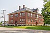
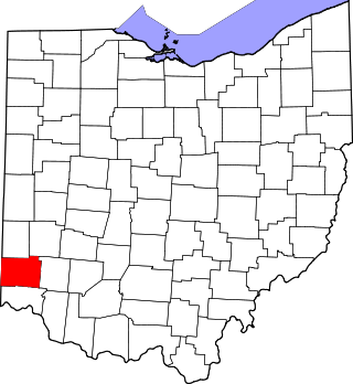
This is a list of the National Register of Historic Places listings in Butler County, Ohio.

<span class="mw-page-title-main">National Register of Historic Places listings in Lucas County, Ohio</span>

This is a list of the National Register of Historic Places listings in Lucas County, Ohio.

<span class="mw-page-title-main">National Register of Historic Places listings in Montgomery County, Ohio</span>

This is a list of the National Register of Historic Places listings in Montgomery County, Ohio.

<span class="mw-page-title-main">National Register of Historic Places listings in Licking County, Ohio</span>

This is a list of the National Register of Historic Places listings in Licking County, Ohio.

<span class="mw-page-title-main">National Register of Historic Places listings in Knox County, Ohio</span>

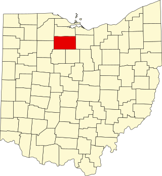
This is a list of the National Register of Historic Places listings in Knox County, Ohio.

<span class="mw-page-title-main">National Register of Historic Places listings in Seneca County, Ohio</span>

This is a list of the National Register of Historic Places listings in Seneca County, Ohio.

<span class="mw-page-title-main">National Register of Historic Places listings in Washington County, Ohio</span>

This is a list of the National Register of Historic Places listings in Washington County, Ohio.

<span class="mw-page-title-main">National Register of Historic Places listings in Ross County, Ohio</span>

This is a list of the National Register of Historic Places listings in Ross County, Ohio.

<span class="mw-page-title-main">National Register of Historic Places listings in Athens County, Ohio</span>

This is a list of the National Register of Historic Places listings in Athens County, Ohio.

<span class="mw-page-title-main">National Register of Historic Places listings in Brown County, Ohio</span>

This is a list of the National Register of Historic Places listings in Brown County, Ohio.

<span class="mw-page-title-main">National Register of Historic Places listings in Ottawa County, Ohio</span>

This is a list of the National Register of Historic Places listings in Ottawa County, Ohio.

<span class="mw-page-title-main">National Register of Historic Places listings in Darke County, Ohio</span>

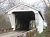
This is a list of the National Register of Historic Places listings in Darke County, Ohio.

<span class="mw-page-title-main">National Register of Historic Places listings in Adams County, Ohio</span>

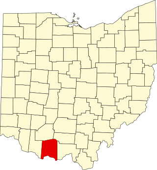
This is a list of the National Register of Historic Places listings in Adams County, Ohio.

<span class="mw-page-title-main">National Register of Historic Places listings in Coshocton County, Ohio</span>

This is a list of the National Register of Historic Places listings in Coshocton County, Ohio.

<span class="mw-page-title-main">National Register of Historic Places listings in Prince George County, Virginia</span>

This is a list of the National Register of Historic Places listings in Prince George County, Virginia.

<span class="mw-page-title-main">National Register of Historic Places listings in Hancock County, Ohio</span>

This is a list of the National Register of Historic Places listings in Hancock County, Ohio.

<span class="mw-page-title-main">National Register of Historic Places listings in Putnam County, Ohio</span>

This is a list of the National Register of Historic Places listings in Putnam County, Ohio.

<span class="mw-page-title-main">National Register of Historic Places listings in Meigs County, Ohio</span>

This is a list of the National Register of Historic Places listings in Meigs County, Ohio.

<span class="mw-page-title-main">National Register of Historic Places listings in Henry County, Ohio</span>

This is a list of the National Register of Historic Places listings in Henry County, Ohio.

<span class="mw-page-title-main">National Register of Historic Places listings in Union County, Indiana</span>

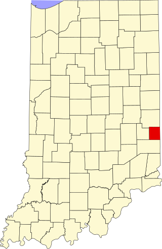
This is a list of the National Register of Historic Places listings in Union County, Indiana.

References

  1. The latitude and longitude information provided in this table was derived originally from the National Register Information System, which has been found to be fairly accurate for about 99% of listings. Some locations in this table may have been corrected to current GPS standards.
  2. National Park Service, United States Department of the Interior, "National Register of Historic Places: Weekly List Actions", retrieved December 15, 2023.
  3. Numbers represent an alphabetical ordering by significant words. Various colorings, defined here, differentiate National Historic Landmarks and historic districts from other NRHP buildings, structures, sites or objects.
  4. 1 2 "National Register Information System". National Register of Historic Places . National Park Service. April 24, 2008.
  5. The eight-digit number below each date is the number assigned to each location in the National Register Information System database, which can be viewed by clicking the number.
  6. Location derived from Hueston Woods State Park Map, Hueston Woods State Park, October 2009. Accessed 2010-08-15. The NRIS lists the site as "Address Restricted"
  7. 1 2 Preble County Covered Bridges, Preble County Historical Society, 2008. Accessed 2009-04-27.
  8. DeLorme. Ohio Atlas & Gazetteer. 7th ed. Yarmouth: DeLorme, 2004, p. 64. ISBN   0-89933-281-1.
  9. Roberts Bridge Covered Bridge