West Manchester, Ohio

Last updated

West Manchester, Ohio
North east of Race, West Manchester.jpg
Houses on North Street
OHMap-doton-West Manchester.png
Location of West Manchester, Ohio
Map of Preble County Ohio Highlighting West Manchester Village.png
Location of West Manchester in Preble County
Coordinates: 39°54′10″N84°37′28″W / 39.90278°N 84.62444°W / 39.90278; -84.62444
Country United States
State Ohio
County Preble
Area
[1]
  Total0.27 sq mi (0.70 km2)
  Land0.27 sq mi (0.70 km2)
  Water0.00 sq mi (0.00 km2)
Elevation
[2]
1,093 ft (333 m)
Population
 (2020)
  Total415
  Density1,525.74/sq mi (589.28/km2)
Time zone UTC-5 (Eastern (EST))
  Summer (DST) UTC-4 (EDT)
ZIP code
45382
Area code(s) 937, 326
FIPS code 39-83804
GNIS feature ID2400137 [2]

West Manchester is a village in Preble County, Ohio, United States. The population was 415 at the 2020 census. It is part of the Dayton Metropolitan Statistical Area.

Contents

Geography

According to the United States Census Bureau, the village has a total area of 0.27 square miles (0.70 km2), all land. [3]

Demographics

Historical population
CensusPop.Note
1880 229
1900 384
1910 44515.9%
1920 409−8.1%
1930 372−9.0%
1940 3956.2%
1950 46918.7%
1960 460−1.9%
1970 4692.0%
1980 448−4.5%
1990 4643.6%
2000 433−6.7%
2010 4749.5%
2020 415−12.4%
U.S. Decennial Census [4]

2010 census

As of the census [5] of 2010, there were 474 people, 167 households, and 123 families living in the village. The population density was 1,755.6 inhabitants per square mile (677.8/km2). There were 179 housing units at an average density of 663.0 per square mile (256.0/km2). The racial makeup of the village was 95.4% White, 1.9% African American, 0.4% Native American, 0.2% from other races, and 2.1% from two or more races. Hispanic or Latino of any race were 1.1% of the population.

There were 167 households, of which 40.7% had children under the age of 18 living with them, 50.3% were married couples living together, 15.6% had a female householder with no husband present, 7.8% had a male householder with no wife present, and 26.3% were non-families. 21.0% of all households were made up of individuals, and 7.2% had someone living alone who was 65 years of age or older. The average household size was 2.84 and the average family size was 3.23.

The median age in the village was 33.3 years. 27.6% of residents were under the age of 18; 11.6% were between the ages of 18 and 24; 28.3% were from 25 to 44; 22.2% were from 45 to 64; and 10.3% were 65 years of age or older. The gender makeup of the village was 48.7% male and 51.3% female.

2000 census

As of the census [6] of 2000, there were 433 people, 168 households, and 124 families living in the village. The population density was 1,851.7 inhabitants per square mile (714.9/km2). There were 177 housing units at an average density of 756.9 per square mile (292.2/km2). The racial makeup of the village was 99.08% White, 0.46% Native American, 0.46% from other races. Hispanic or Latino of any race were 1.39% of the population.

There were 168 households, out of which 38.7% had children under the age of 18 living with them, 60.7% were married couples living together, 10.7% had a female householder with no husband present, and 25.6% were non-families. 22.0% of all households were made up of individuals, and 8.3% had someone living alone who was 65 years of age or older. The average household size was 2.58 and the average family size was 3.06.

In the village, the population was spread out, with 26.8% under the age of 18, 12.0% from 18 to 24, 30.7% from 25 to 44, 20.3% from 45 to 64, and 10.2% who were 65 years of age or older. The median age was 31 years. For every 100 females there were 100.5 males. For every 100 females age 18 and over, there were 93.3 males.

The median income for a household in the village was $34,063, and the median income for a family was $39,583. Males had a median income of $32,000 versus $20,781 for females. The per capita income for the village was $16,968. About 4.3% of families and 7.7% of the population were below the poverty line, including 2.0% of those under age 18 and 16.7% of those age 65 or over.

Education

The National Trail Local School District serves students in West Manchester along with surrounding Monroe Township. West Manchester has a public library, a branch of the Preble County District Library. [7]

Related Research Articles

<span class="mw-page-title-main">Preble County, Ohio</span> County in Ohio, United States

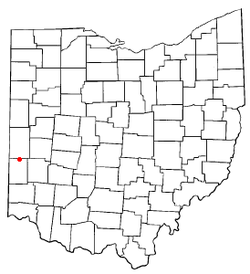
Preble County is a county located in the U.S. state of Ohio. As of the 2020 census, the population was 40,999, down 3.0% from the 2010 census population of 42,270. Its county seat is Eaton. The county was formed on February 15, 1808, from portions of Butler and Montgomery Counties. It is named for Edward Preble, a naval officer who fought in the American Revolutionary War and against the Barbary Pirates.

<span class="mw-page-title-main">Manchester, Kansas</span> City in Dickinson County, Kansas

Manchester is a city in Dickinson County, Kansas, United States. As of the 2020 census, the population of the city was 47.

<span class="mw-page-title-main">Manchester, Maine</span> Town in Maine, United States

Manchester is a town in Kennebec County, Maine, United States, located at 44.33°N 69.87°W. The population was 2,456 at the 2020 census. The southern part of the town bordering Cobbosseecontee Lake is a popular recreation spot in central Maine, and part of the Winthrop Lakes Region. Manchester is included in the Augusta, Maine micropolitan and included in the Lewiston-Auburn, Maine metropolitan New England City and Town Area.

Preble Township is a township in Fillmore County, Minnesota, United States. The population was 272 at the 2000 census.

<span class="mw-page-title-main">Manchester, Missouri</span> City in Missouri, United States

Manchester is a city in St. Louis County, Missouri, United States. The population was 18,333 at the 2020 census.

<span class="mw-page-title-main">Twin Oaks, Missouri</span> City in Missouri, United States

Twin Oaks is a 4th class city in St. Louis County, Missouri, United States. The former Village of Twin Oaks changed its status to that of a city by public election in November 2016. The population was 392 at the 2010 census.

<span class="mw-page-title-main">Preble, New York</span> Town in New York, United States

Preble is a town in Cortland County, New York, United States. The population was 1,357 at the 2020 census, down from 1,393 at the 2010 census. The town is named after Commodore Edward Preble, a naval hero.

<span class="mw-page-title-main">Manchester, Ohio</span> Village in Ohio, United States

Manchester is a village in Manchester Township, Adams County, Ohio, United States, along the Ohio River. The population was 1,839 at the 2020 census.

<span class="mw-page-title-main">Castine, Ohio</span> Village in Ohio, United States

Castine is a village in Darke County, Ohio, United States. The population was 110 at the 2020 census.

<span class="mw-page-title-main">Camden, Ohio</span> Village in Ohio, United States

Camden is a village in Preble County, Ohio, United States. The population was 1,989 at the 2020 census.

<span class="mw-page-title-main">Eaton, Ohio</span> City in Ohio, United States

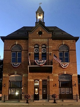
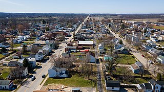
Eaton is a city in, and the county seat of Preble County, Ohio, United States, approximately 24 mi (38 km) west of Dayton. The population was 8,375 at the 2020 census, down 0.4% from the population of 8,407 at the 2010 census.

<span class="mw-page-title-main">Eldorado, Ohio</span> Village in Ohio, United States

Eldorado is a village in Preble County, Ohio, United States. The population was 458 at the 2020 census. It is part of the Dayton Metropolitan Statistical Area.

<span class="mw-page-title-main">Gratis, Ohio</span> Village in Ohio, United States

Gratis is a village in Preble County, Ohio, United States. The population was 842 at the 2020 census. It is part of the Dayton Metropolitan Statistical Area.

<span class="mw-page-title-main">Lewisburg, Ohio</span> Village in Ohio, United States

Lewisburg is a village in Preble County, Ohio, United States, founded in 1818. The current village incorporates two prior villages, the original Lewisburg and Euphemia, which merged in 1916. The population was 1,745 at the 2020 census. It is part of the Dayton Metropolitan Statistical Area.

<span class="mw-page-title-main">New Paris, Ohio</span> Village in Ohio, United States

New Paris is a village in Preble County, Ohio, United States. The population was 1,494 at the 2020 census. It is part of the Dayton Metropolitan Statistical Area.

<span class="mw-page-title-main">West Alexandria, Ohio</span> Village in Ohio, United States

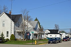
West Alexandria is a village in Preble County, Ohio, United States. The population was 1,334 at the 2020 census.

<span class="mw-page-title-main">West Elkton, Ohio</span> Village in Ohio, United States

West Elkton is a village in Preble County, Ohio, United States. The population was 164 at the 2020 census. It is part of the Dayton Metropolitan Statistical Area.

<span class="mw-page-title-main">College Corner, Ohio</span> Village in Ohio, United States

College Corner is a village in Butler and Preble counties in the southwestern part of the U.S. state of Ohio, 5 miles (8 km) northwest of Oxford. The population was 387 at the 2020 census. The village lies on the state line with Indiana, where it borders the town of West College Corner. The public school, part of the Union County–College Corner Joint School District, is bisected by the state line and is operated jointly with Indiana authorities.

<span class="mw-page-title-main">Verona, Ohio</span> Village in Ohio, United States

Verona is a village in Montgomery and Preble counties in the U.S. state of Ohio. The population was 403 at the 2020 census. It is part of the Dayton Metropolitan Statistical Area.

<span class="mw-page-title-main">Lowell, Wisconsin</span> Village in Wisconsin, United States

Lowell is a village in Dodge County, Wisconsin, United States, along the Beaver Dam River. The population was 340 at the 2010 census. The village is located within the Town of Lowell.

References

  1. "ArcGIS REST Services Directory". United States Census Bureau. Retrieved September 20, 2022.
  2. 1 2 U.S. Geological Survey Geographic Names Information System: West Manchester, Ohio
  3. "US Gazetteer files 2010". United States Census Bureau . Retrieved January 6, 2013.
  4. "Census of Population and Housing". Census.gov. Retrieved June 4, 2015.
  5. "U.S. Census website". United States Census Bureau . Retrieved January 6, 2013.
  6. "U.S. Census website". United States Census Bureau . Retrieved January 31, 2008.
  7. "Locations". Preble County District Library. Retrieved March 3, 2018.