
Trumbull County is a county in the far northeast portion of U.S. state of Ohio. As of the 2020 census, the population was 201,977. Its county seat and largest city is Warren, which developed industry along the Mahoning River. Trumbull County is part of the Youngstown-Warren-Boardman, OH-PA Metropolitan Statistical Area.

Mahoning County is a county in the U.S. state of Ohio. As of the 2020 census, the population was 228,614. Its county seat and largest city is Youngstown. The county is named after the Mahoning River and was formed on March 1, 1846; the 83rd county in Ohio. Until 1846, the area that is now Mahoning County was part of Trumbull and Columbiana counties, when the counties in the area were redefined and Mahoning County emerged as a new county. Mahoning County is part of the Youngstown-Warren-Boardman, OH-PA Metropolitan Statistical Area.

Appalachia is a cultural region in the Eastern United States that stretches from the Southern Tier of New York State to northern Alabama and Georgia. While the Appalachian Mountains stretch from Belle Isle in Newfoundland and Labrador, Canada, to Cheaha Mountain in Alabama, Appalachia typically refers only to the cultural region of the central and southern portions of the range, from the Catskill Mountains of New York southwest to the Blue Ridge Mountains which run southwest from southern Pennsylvania to northern Georgia, and the Great Smoky Mountains of Tennessee and North Carolina. In 2020, the region was home to an estimated 26.1 million people, of whom roughly 80% are white.

The region Northeast Ohio, in the US state of Ohio, in its most expansive usage contains six metropolitan statistical areas: Cleveland–Elyria, Akron, Canton–Massillon, Youngstown–Warren, Mansfield, and Weirton–Steubenville along with eight micropolitan statistical areas. Most of the region is considered either part of the Cleveland–Akron–Canton, OH Combined Statistical Area and media market or the Youngstown–Warren, OH-PA Combined Statistical Area and media market. In total the region is home to 4,502,460 residents. It is also a part of the Great Lakes megalopolis, containing over 54 million people. Northeast Ohio also includes most of the area known historically as the Connecticut Western Reserve. In 2011, the Intelligent Community Forum ranked Northeast Ohio as a global Smart 21 Communities list. It has the highest concentration of Hungarian Americans in the United States.

The Cumberland Plateau is the southern part of the Appalachian Plateau in the Appalachian Mountains of the United States. It includes much of eastern Kentucky and Tennessee, and portions of northern Alabama and northwest Georgia. The terms "Allegheny Plateau" and the "Cumberland Plateau" both refer to the dissected plateau lands lying west of the main Appalachian Mountains. The terms stem from historical usage rather than geological difference, so there is no strict dividing line between the two. Two major rivers share the names of the plateaus, with the Allegheny River rising in the Allegheny Plateau and the Cumberland River rising in the Cumberland Plateau in Harlan County, Kentucky.
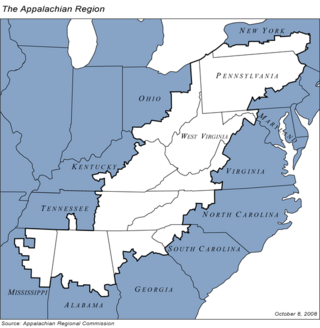
The Appalachian Regional Commission (ARC) is a United States federal–state partnership that works with the people of Appalachia to create opportunities for self-sustaining economic development and improved quality of life. Congress established ARC to bring the region into socioeconomic parity with the rest of the nation.

State Route 11 is a north–south freeway in the northeastern portion of the U.S. state of Ohio. Its southern terminus is at U.S. Route 30 in East Liverpool at the West Virginia state line on the Jennings Randolph Bridge over the Ohio River; its northern terminus is at SR 531 in Ashtabula. The route is concurrent with US 30 through East Liverpool and with Interstate 80 (I-80) near Youngstown. The first section of the route to be completed, from Canfield to Austintown, opened in 1969. The entire current route was complete in 1972, and upgraded to a divided highway by 1980.

This is a list of high school athletic conferences in Ohio, separated by Ohio High School Athletic Association (OHSAA) region. Some conferences have schools in multiple regions, and will be listed in all applicable regions. However, the conference information is on the region page where the most schools are classified in.

The Diocese of Youngstown is a Latin Church ecclesiastical territory or diocese of the Catholic Church, consisting of six counties in Northeast Ohio: Mahoning, Trumbull, Columbiana, Stark, Portage, and Ashtabula. The Diocese of Youngstown is suffragan diocese in the ecclesiastical province of the metropolitan Archdiocese of Cincinnati.

Greater Pittsburgh is a populous region centered around Pittsburgh, Pennsylvania, the region's largest city and economic hub. The region encompasses Pittsburgh's urban core county, Allegheny, and six adjacent Pennsylvania counties: Armstrong, Beaver, Butler, Fayette, Washington, and Westmoreland in Western Pennsylvania, which constitutes the Pittsburgh, PA Metropolitan Statistical Area MSA as defined by the U.S. Census Bureau.

Western North Carolina is the region of North Carolina which includes the Appalachian Mountains; it is often known geographically as the state's Mountain Region. It contains the highest mountains in the Eastern United States, with 125 peaks rising to over 5,000 feet in elevation. Mount Mitchell at 6,684 feet, is the highest peak of the Appalachian Mountains and mainland eastern North America. The population of the region, as measured by the 2010 U.S. Census, is 1,473,241, which is approximately 15% of North Carolina's total population.
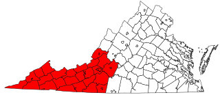
Southwest Virginia, often abbreviated as SWVA, is a mountainous region of Virginia in the westernmost part of the commonwealth. Located within the broader region of western Virginia, Southwest Virginia has been defined alternatively as all Virginia counties on the Appalachian Plateau, all Virginia counties west of the Eastern Continental Divide, or at its greatest expanse, as far east as Blacksburg and Roanoke. Another geographic categorization of the region places it as those counties within the Tennessee River watershed. Regardless of how borders are drawn, Southwest Virginia differs from the rest of the commonwealth in that its culture is more closely associated with Appalachia than the other regions of Virginia. Historically, the region has been and remains a rural area, but in the 20th century, coal mining became an important part of its economy. With the decline in the number of coal jobs and the decline of tobacco as a cash crop, Southwest Virginia is increasingly turning to tourism as a source of economic development. Collectively, Southwest Virginia's craft, music, agritourism and outdoor recreation are referred to as the region's "creative economy."

State Route 46 (SR 46) is a north–south state highway in the northeastern portion of the U.S. state of Ohio. Its southern terminus is at State Route 170 in East Palestine, and its northern terminus is at State Route 11 several miles south of State Route 531 in Plymouth Township. In its northernmost portion, from south of Ashtabula to Cortland, Route 46 is a 2-lane highway while running parallel within a few miles to limited-access State Route 11 to the east.

The Upland South and Upper South are two overlapping cultural and geographic subregions in the inland part of the Southern and lower Midwestern United States. They differ from the Deep South and Atlantic coastal plain by terrain, history, economics, demographics, and settlement patterns.

The Youngstown–Warren–Boardman, OH–PA Metropolitan Statistical Area, typically known as the Mahoning Valley, is a metropolitan area in Northeast Ohio and Western Pennsylvania with Youngstown, Ohio, at its center. According to the U.S. Census Bureau, the metropolitan statistical area (MSA) includes Mahoning and Trumbull counties in Ohio and Mercer County in Pennsylvania. As of the 2020 census, the region had a population of 541,243, making it the 107th largest metro area in the country.
In the United States, the Hillbilly Highway is the out-migration of Appalachians from the Appalachian Highlands region to industrial cities in northern, midwestern, and western states, primarily in the years following World War II in search of better-paying industrial jobs and higher standards of living. Many of these migrants were formerly employed in the coal mining industry, which started to decline in 1940s. The word hillbilly refers to a negative stereotype of people from Appalachia. The term hillbilly is considered to be a modern term because it showed up in the early 1900s. The Hillbilly Highway was a parallel to the better-known Great Migration of African-Americans from the south.
Appalachia is a region of the Eastern United States. Home to over 25 million people, the region includes mountainous areas of 13 states: Mississippi, Alabama, Pennsylvania, New York, Georgia, South Carolina, North Carolina, Tennessee, Virginia, Kentucky, Ohio, Maryland, as well as the entirety of West Virginia.


