
The North Country Trail is a long-distance hiking trail in the Midwestern and Northeastern United States. The trail extends roughly 4,800 miles (7,700 km) from Lake Sakakawea State Park in North Dakota to the Appalachian Trail in Green Mountain National Forest in Vermont, passing through eight states along its route. As of 2023, most of the trail is in place, though about one-third of the distance consists of road walking; those segments are frequently evaluated for transfer to off-road segments on nearby public or private lands.
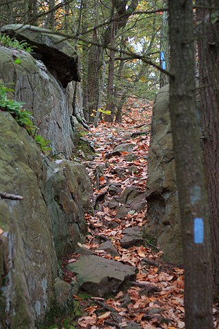
The Buckeye Trail is a 1,444-mile (2,324 km) hiking trail and long-distance trail that loops around the state of Ohio. Part of it is on roads and part is on wooded trail. Road portions of the trail are gradually being relocated to separate trail.

The Hocking River is a 102-mile-long (164 km) right tributary of the Ohio River in southeastern Ohio in the United States.
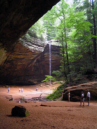
Hocking Hills State Park is a state park in the Hocking Hills region of Hocking County, Ohio, United States. In some areas the park adjoins the Hocking State Forest. Within the park are over 25 miles (40 km) of hiking trails, rock formations, waterfalls, and recess caves. The trails are open from dawn to dusk, all year round, including holidays.

The American Discovery Trail is a system of recreational trails and roads that collectively form a coast-to-coast hiking and biking trail across the mid-tier of the United States. Horses can also be ridden on most of this trail. The coastal trailheads are the Delmarva Peninsula on the Atlantic Ocean and the northern California coast on the Pacific Ocean. The trail has northern and southern alternates for part of its distance, passing through Chicago and St. Louis respectively. The total length of the trail, including both the north and south routes, is 6,800 miles (10,900 km). The northern route covers 4,834 miles (7,780 km) with the southern route covering 5,057 miles (8,138 km). It is the only non-motorized coast-to-coast trail.

Lake Katharine State Nature Preserve is located in Jackson County, Ohio, United States, just northwest of and outside the city of Jackson. It is owned and administered by the State Division of Natural Areas and Preserves and comprises 2,019 acres (817 ha).

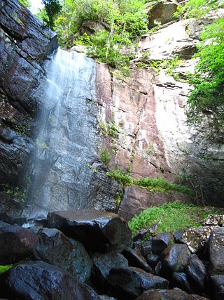
Fall Creek Falls State Resort Park is a state park in Van Buren and Bledsoe counties, in the U.S. state of Tennessee. The over 30,638-acre (123.99 km2) park is centered on the upper Cane Creek Gorge, an area known for its unique geological formations and scenic waterfalls. The park's namesake is the 256-foot (78 m) Fall Creek Falls, the highest free-fall waterfall east of the Mississippi River.

Emma Rowena (Caldwell) Gatewood, known as Grandma Gatewood,, was an American ultra-light hiking pioneer. After a difficult life as a farm wife, mother of eleven children, and survivor of domestic violence, she became famous as the first solo female thru-hiker of the 2,168-mile (3,489 km) Appalachian Trail (A.T.) in 1955 at the age of 67. She subsequently became the first person to hike the A.T. three times, after completing a second thru-hike two years later, followed by a section-hike in 1964. In the meantime, she hiked 2,000 miles (3,200 km) of the Oregon Trail in 1959. In her later years, she continued to travel and hike, and worked on a section of what would become the Buckeye Trail. The media coverage surrounding her feats was credited for generating interest in maintaining the A.T. and in hiking generally. Among many other honors, she was posthumously inducted into the Appalachian Trail Hall of Fame in 2012.
The Metacomet Trail is a 62.7-mile (100.9 km) Blue-Blazed hiking trail that traverses the Metacomet Ridge of central Connecticut and is a part of the newly designated New England National Scenic Trail. Despite being easily accessible and close to large population centers, the trail is considered remarkably rugged and scenic. The route includes many areas of unique ecologic, historic, and geologic interest. Notable features include waterfalls, dramatic cliff faces, woodlands, swamps, lakes, river flood plain, farmland, significant historic sites, and the summits of Talcott Mountain and the Hanging Hills. The Metacomet Trail is maintained largely through the efforts of the Connecticut Forest and Park Association.

The Appalachian mixed mesophytic forests is an ecoregion of the temperate broadleaf and mixed forests biome, as defined by the World Wildlife Fund. It consists of mesophytic plants west of the Appalachian Mountains in the Southeastern United States.
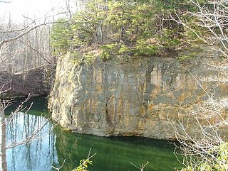
The Blackhand Gorge State Nature Preserve is a 4-mile-long (6.4 km) sandstone formation through which the Licking River flows in Licking County, Ohio, United States. Located 12 miles (19 km) east of Newark near the tiny town of Toboso, 957 acres (387 ha) along the gorge were designated an Ohio Nature Preserve in 1975. The gorge is a capsule of Ohio transportation history, having hosted canal boats, steam railroads, electric interurbans, and automobiles through the years. It is named for the black hand petroglyph that was found on the cliff face by the first settlers to the area. Black Hand Sandstone is a resistant rock that also forms the backbone of the Hocking Hills region.

The Columbus and Franklin County Metro Parks are a group of 20 metropolitan parks in and around Columbus, Ohio. They are officially organized into the Columbus and Franklin County Metropolitan Park District. The Metro Parks system was organized in 1945 under Ohio Revised Code Section 1545 as a separate political division of the state of Ohio. The Metro Parks are overseen by a Board of Park Commissioners consisting of three citizens appointed to three-year terms without compensation by the Judge of the Probate Court of Franklin County, Ohio. The Board in turn appoints an Executive Director responsible for operations and management of the parks.
Bad Branch Falls State Nature Preserve is a forested gorge covering 2,639 acres near Whitesburg, KY in Letcher County, Kentucky. The deep and narrow gorge, adjacent to the Jefferson National Forest is carved into the face of Pine Mountain. Sandstone boulders and cliffs along with riglines and knobs provide views into the Appalachia area. The terrain is landscaped with streams, rivers, and a 60-foot waterfall. With a variety of habitat types, this nature preserve is home to many unique and unknown species of flora and fauna.

Hocking Hills Reservoir locally nicknamed Rose Lake is located just outside Old Man's Cave, in the Hocking Hills region of Hocking County, Ohio, United States. It is a part of the Hocking Hills State Park.

State Route 664 is a north–south state highway in the southern portion of the U.S. state of Ohio. The highway has its southern terminus at a T-intersection with SR 56 in the unincorporated community of South Bloomingville. The northern terminus of SR 664 is also at a T-intersection, this time with SR 256 on the Fairfield–Perry county line approximately 4.75 miles (7.64 km) north of the village of Rushville.
Hocking State Forest is a state forest in Hocking County, Ohio, United States. The forest adjoins Hocking Hills State Park and three nature preserves including Conkle's Hollow State Nature Preserve.
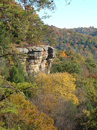
Conkle's Hollow State Nature Preserve is a deep, cool gorge, which is only 100 feet wide in places and is considered by some to be the deepest in Ohio. The cliffs above the gorge are about 200 feet tall. The valley floor is covered in many species of plants, such as ferns, hemlock, and various wildflowers. It is located within Hocking Hills State Park.

State Route 374 is north–south state highway in Hocking County, Ohio, located in the southern portion of the state. Its southern terminus is over 4 miles (6.4 km) east of the unincorporated village of South Bloomingville at State Route 56, and its northern terminus is near the unincorporated village of Rockbridge at US 33, west of Logan. The road serves Hocking State Forest as well as Hocking Hills State Park, and the entire highway is part of the designated Hocking Hills Scenic Byway.

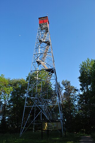
Clear Creek Metro Park is a nature preserve located at 185 Clear Creek Road in Rockbridge, Ohio, just off U.S. Route 33. It is part of the Columbus and Franklin County Metro Parks system. It also contains the largest Ohio State Nature Preserve. Open 6:30 am until dark, the park is home to over 800 plant species and over 150 species of birds.

