Wayne National Forest

Last updated

Wayne National Forest
Wayne National Forest Welcome Entrance Sign.jpg
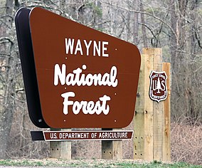
Welcome Sign for Wayne National Forest
Oh forests.png
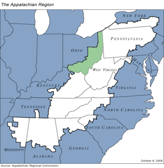
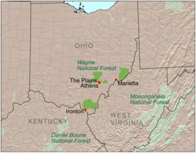
Location of Wayne National Forest
LocationOhio, United States
Coordinates 39°30′0″N82°0′0″W / 39.50000°N 82.00000°W / 39.50000; -82.00000
Area240,101 acres (971.65 km2) [1]
EstablishedDecember 1992 [2]
Named for Anthony Wayne
Website Wayne National Forest

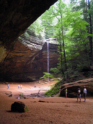
The Wayne National Forest is located in the south-eastern part of the US state of Ohio, in the Unglaciated Allegheny Plateau. It is the only national forest in Ohio. Forest headquarters are located between The Plains and Nelsonville, Ohio, on US Route 33 overlooking the Hocking River.

The originally forested land was cleared for agricultural and lumbering use in the late 18th and 19th century, but years of poor timbering and agricultural practices led to severe erosion and poor soil composition. The Wayne National Forest was started as part of a reforestation program. [3] It was established as a National Forest for the public in December 1992.

The Wayne National Forest was named in honor of General Anthony Wayne, an American soldier, officer, statesman, and one of the Founding Fathers of the United States. He served in the American Revolutionary War and was later recalled from civilian life by President George Washington after St. Clair's defeat to command the Legion of the United States in the Northwest Indian War to gain control of the British occupied ceded Northwest Territory, including the region that is now Ohio. [4]

On August 21, 2023, the U.S. Forest Service announced a proposal to rename Wayne National Forest, citing "complicated legacy includes leading a violent campaign against the Indigenous peoples of Ohio that resulted in their removal from their homelands". New proposed names include "Buckeye National Forest", "Ohio National Forest", and "Koteewa National Forest". [5]

The forest comprises three administrative and purchase units: Athens, Marietta, and Ironton. The Athens and Marietta Units are managed together as the Athens Ranger District, while the Ironton Unit is managed as the Ironton Ranger District. Many of the lands included in the national forest are former coal-mining lands, and much of this land is owned by the federal government without the mineral rights, those having been retained by former owners.

As of September 2018, Wayne National Forest has 244,265 acres (989 km2) in federal ownership within a proclamation boundary of 832,147 acres (3,368 km2). [1]

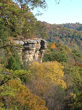
The North Country Trail passes through several areas of Wayne, in which it is coincident with the Buckeye Trail and the American Discovery Trail. The area of Ohio included within the national forest is based on late Paleozoic geology, heavy in sandstones and shales, including redbeds, with many coal beds. The topography is typically very rugged, with elevation changes typically in the 200–400-foot range.

Related Research Articles

<span class="mw-page-title-main">Athens, Ohio</span> City in Ohio, United States

Athens is a city and the county seat of Athens County, Ohio, United States. The population was 23,849 at the 2020 census. Located along the Hocking River within Appalachian Ohio about 65 miles (105 km) southeast of Columbus, Athens is best known as the home of Ohio University, a large public research university with an undergraduate and graduate enrollment of more than 21,000 students. It is the principal city of the Athens micropolitan area.

<span class="mw-page-title-main">Washington County, Ohio</span> County in Ohio, United States

Washington County is a county located in the southeastern part of the U.S. state of Ohio. As of the 2020 census, the population was 59,711. Its county seat is Marietta. The county, the oldest in the state, is named for George Washington. Washington County comprises the Marietta, OH Micropolitan Statistical Area, which is also included in the Parkersburg-Marietta-Vienna, WV-OH Combined Statistical Area.

<span class="mw-page-title-main">Vinton County, Ohio</span> County in Ohio, United States

Vinton County is a county located in the U.S. state of Ohio. As of the 2020 census, the population was 12,800, making it the least populous county of Ohio. Its county seat is McArthur. The county is named for Samuel Finley Vinton, US Representative from Ohio.

<span class="mw-page-title-main">Hocking County, Ohio</span> County in Ohio, United States

Hocking County is a county located in the U.S. state of Ohio. As of the 2020 census, the population was 28,050. Its county seat is Logan. The county was organized on March 1, 1818, from land given by Athens, Fairfield, and Ross counties. Its name is from the Hocking River, the origins of which are disputed but is said to be a Delaware Indian word meaning "bottle river". Hocking County is included in the Columbus, OH Metropolitan Statistical Area.

<span class="mw-page-title-main">Athens County, Ohio</span> County in Ohio, United States

Athens County is a county in southeastern Ohio. As of the 2020 census, the population was 62,431. Its county seat and largest city is Athens. The county was formed in 1805 from Washington County. Because Ohio's first state university, Ohio University, was established here in 1804, the town and the county are named for the ancient center of learning, Athens, Greece.

<span class="mw-page-title-main">Scouting in Ohio</span>

Scouting in Ohio has a long history, from the 1908 to the present day, serving thousands of youth in programs that suit the environment in which they live.

<span class="mw-page-title-main">Glouster, Ohio</span> Village in Ohio, United States

Glouster is a village in Trimble Township, Athens County, Ohio, United States. The population was 1,659 at the 2020 census. It is close to Burr Oak State Park.

<span class="mw-page-title-main">Nelsonville, Ohio</span> City in Ohio, United States

Nelsonville is a city in northwestern Athens County, Ohio, United States, located about 60 miles (97 km) southeast of Columbus. The population was 5,373 at the 2020 census. It is home to Hocking College as well as Rocky Brands. Nelsonville is surrounded by Ohio's only national forest, the Wayne National Forest.

<span class="mw-page-title-main">Daniel Boone National Forest</span> National forest in Kentucky

The Daniel Boone National Forest is a national forest in Kentucky. Established in 1937, it includes 708,000 acres (287,000 ha) of federally owned land within a 2,100,000-acre (850,000 ha) proclamation boundary. The name of the forest was changed in 1966 in honor of the explorer Daniel Boone.

<span class="mw-page-title-main">Hocking Hills State Park</span> State park in Ohio, United States

Hocking Hills State Park is a state park in the Hocking Hills region of Hocking County, Ohio, United States. In some areas the park adjoins the Hocking State Forest. Within the park are over 25 miles (40 km) of hiking trails, rock formations, waterfalls, and recess caves. The trails are open from dawn to dusk, all year round, including holidays.

<span class="mw-page-title-main">Hocking Hills</span>

The Hocking Hills is a deeply dissected area of the Allegheny Plateau in Appalachian Ohio, primarily in Hocking County, that features cliffs, gorges, rock shelters, and waterfalls. The relatively extreme topography in this area is due to the Blackhand Sandstone, a particular formation that is thick, hard and weather-resistant, and so forms high cliffs and narrow, deep gorges.

<span class="mw-page-title-main">Burr Oak State Park</span> Park in Ohio, USA

Burr Oak State Park is a public recreation area located four miles (6.4 km) northeast of Glouster in the U.S. state of Ohio. The park sits mostly in Morgan County, with part extending into Athens County.

<span class="mw-page-title-main">Idaho Panhandle National Forests</span> National forests in Idaho, United States

The Idaho Panhandle National Forests are a jointly administered set of three national forests located mostly in the U.S. state of Idaho. In 1973, major portions of the Kaniksu, Coeur d'Alene, and St. Joe National Forests were combined to be administratively managed as the Idaho Panhandle National Forests (IPNF). The IPNF consists of more than 2.5 million acres (10,000 km2) of public lands in the panhandle of north Idaho, with small areas extending into eastern Washington (4.7%) and western Montana (1.2%). The northernmost portion of the IPNF share a boundary with Canada. The Forest Supervisor's office is located in Coeur d'Alene, Idaho with district office's in Bonners Ferry, Sandpoint, Priest River, Fernan and Smelterville, and St. Maries and Avery.

<span class="mw-page-title-main">Ohio high school athletic conferences</span>

This is a list of high school athletic conferences in Ohio, separated by Ohio High School Athletic Association (OHSAA) region. Some conferences have schools in multiple regions, and will be listed in all applicable regions. However, the conference information is on the region page where the most schools are classified in.

Ohio's 6th congressional district is a U.S. congressional disctict which was represented by U.S. Representative Bill Johnson of the Republican Party until his resignation in 2024. A special election will be held on June 11, 2024 to fill the seat for the remainder of the 118th Congress.

<span class="mw-page-title-main">Monday Creek</span> River in Ohio, United States

Monday Creek is a tributary of the Hocking River, 27 miles (43 km) long, in southeastern Ohio in the United States. Via the Hocking and Ohio Rivers, it is part of the watershed of the Mississippi River, draining an area of 116 square miles (300 km2) on the unglaciated portion of the Allegheny Plateau. Monday Creek has been badly affected by acid mine drainage.

<span class="mw-page-title-main">Appalachian Ohio</span> Region of Ohio

Appalachian Ohio is a bioregion and political unit in the southeastern part of the U.S. state of Ohio, characterized by the western foothills of the Appalachian Mountains and the Appalachian Plateau. The Appalachian Regional Commission defines the region as consisting of thirty-two counties. This region roughly overlaps with the Appalachian mixed-mesophytic forests, which begin in southeast Ohio and southwest Pennsylvania and continue south to Georgia and Alabama. The mixed-mesophytic forest is found only in Central and Southern Appalachia and eastern/central China. It is one of the most biodiverse temperate forests in the world.

Dysart Woods is the largest remaining tract of old growth forest in southeastern Ohio. It is located in the unglaciated Allegheny Plateau in Belmont County almost five miles (8 km) from the village of Belmont on Ohio State Route 147.

This is a list of high school athletic conferences in the East and Southeast Regions of Ohio, as defined by the OHSAA. Because the names of localities and their corresponding high schools do not always match and because there is often a possibility of ambiguity with respect to either the name of a locality or the name of a high school, the following table gives both in every case, with the locality name first, in plain type, and the high school name second in boldface type. The school's team nickname is given last.

References

  1. 1 2 "Land Areas of the National Forest System" (PDF). U.S. Forest Service. January 2012. Retrieved June 30, 2012.
  2. "History". Wayne National Forest. Archived from the original on November 21, 2001. Retrieved January 19, 2009.
  3. Mangus, Michael; Herman, Jennifer L. (2008). Ohio Encyclopedia. North American Book Dist LLC. p. 570. ISBN   978-1-878592-68-2.
  4. Stockwell, Mary (January 1, 2018). Unlikely General: "Mad" Anthony Wayne and the Battle for America. Yale University Press. p. 211. ISBN   978-0-300-21475-8.
  5. "Wayne National Forest Proposes Changing Name to Buckeye National Forest". U.S. Forest Service. August 21, 2023. Retrieved August 30, 2023.