Licking County, Ohio

Last updated

Licking County
Newark-ohio-courthouse.jpg
Flag of Licking County, Ohio.svg
Licking County oh seal.png
Map of Ohio highlighting Licking County.svg
Location within the U.S. state of Ohio
Ohio in United States.svg
Ohio's location within the U.S.
Coordinates: 40°05′N82°29′W / 40.09°N 82.48°W / 40.09; -82.48
CountryFlag of the United States.svg United States
StateFlag of Ohio.svg  Ohio
FoundedMarch 1, 1808 [1]
Seat Newark
Largest cityNewark
Area
  Total687 sq mi (1,780 km2)
  Land683 sq mi (1,770 km2)
  Water5.0 sq mi (13 km2)  0.7%
Population
 (2020)
  Total178,519
  Estimate 
(2021)
180,401 Increase2.svg
  Density260/sq mi (100/km2)
Time zone UTC−5 (Eastern)
  Summer (DST) UTC−4 (EDT)
Congressional district 12th
Website www.lcounty.com

Licking County is a county located in the central portion of the U.S. state of Ohio. At the 2020 census, the population was 178,519. [2] Its county seat is Newark. [3] The county was formed on January 30, 1808, from portions of Fairfield County.

Contents

It is named after the Licking River, which is thought to be named for the salt licks that were in the area. [4] However, one account explains it as an English pronunciation of the river's indigenous Delaware name W'li/'ik'/nk, which means "where the flood waters recede". [5]

Licking County is part of the Columbus, OH Metropolitan Statistical Area.

Geography

According to the United States Census Bureau, the county has a total area of 687 square miles (1,780 km2), of which 683 square miles (1,770 km2) is land and 5.0 square miles (13 km2) (0.7%) is water. [6] It is the third-largest county in Ohio by land area.

Adjacent counties

Major highways

Demographics

Historical population
CensusPop.Note
1810 3,852
1820 11,861207.9%
1830 20,86975.9%
1840 35,09668.2%
1850 38,84610.7%
1860 37,011−4.7%
1870 35,756−3.4%
1880 40,45013.1%
1890 43,2797.0%
1900 47,0708.8%
1910 55,59018.1%
1920 56,4261.5%
1930 59,9626.3%
1940 62,2793.9%
1950 70,64513.4%
1960 90,24227.7%
1970 107,79919.5%
1980 120,98112.2%
1990 128,3006.0%
2000 145,49113.4%
2010 166,49214.4%
2020 178,5197.2%
2021 (est.)180,401 [7] 1.1%
U.S. Decennial Census [8]
1790-1960 [9] 1900-1990 [10]
1990-2000 [11] 2010-2020 [2]

2000 census

As of the census of 2000, there were 146,491 people, 55,609 households, and 40,149 families living in the county. The population density was 212 inhabitants per square mile (82/km2). There were 58,760 housing units at an average density of 86 units per square mile (33 units/km2). The racial makeup of the county was 95.64% White, 2.06% Black or African American, 0.30% Native American, 0.58% Asian, 0.02% Pacific Islander, 0.30% from other races, and 1.10% from two or more races. 0.76% of the population were Hispanic or Latino of any race. [12] Of the 55,609 households 34.40% had children under the age of 18 living with them, 58.50% were married couples living together, 10.00% had a female householder with no husband present, and 27.80% were non-families. 23.10% of households were one person and 9.10% were one person aged 65 or older. The average household size was 2.56 and the average family size was 3.01.

The age distribution was 26.00% under the age of 18, 8.80% from 18 to 24, 29.40% from 25 to 44, 23.90% from 45 to 64, and 11.90% 65 or older. The median age was 37 years. For every 100 females there were 94.80 males. For every 100 females age 18 and over, there were 92.00 males.

The median household income was $44,124 and the median family income was $51,969. Males had a median income of $37,957 versus $26,884 for females. The per capita income for the county was $20,581. About 5.50% of families and 7.50% of the population were below the poverty line, including 9.10% of those under age 18 and 7.50% of those age 65 or over.

2010 census

As of the census of 2010, there were 166,492 people, 63,989 households, and 45,162 families living in the county. [13] The population density was 243.9 inhabitants per square mile (94.2/km2). There were 69,291 housing units at an average density of 101.5 units per square mile (39.2 units/km2). [14] The racial makeup of the county was 93.2% white, 3.4% black or African American, 0.7% Asian, 0.3% American Indian, 0.4% from other races, and 1.9% from two or more races. Those of Hispanic or Latino origin made up 1.4% of the population. [13] In terms of ancestry, 29.5% were German, 16.0% were Irish, 13.0% were English, 10.8% were American, and 5.5% were Italian. [15]

Of the 63,989 households, 34.2% had children under the age of 18 living with them, 54.5% were married couples living together, 11.2% had a female householder with no husband present, 29.4% were non-families, and 23.8% of households were made up of individuals. The average household size was 2.55 and the average family size was 3.00. The median age was 39.1 years. [13]

The median household income was $53,291 and the median family income was $64,386. Males had a median income of $47,391 versus $37,054 for females. The per capita income for the county was $25,534. About 8.2% of families and 11.1% of the population were below the poverty line, including 15.7% of those under age 18 and 6.5% of those age 65 or over. [16]

Politics

Prior to 1944, Licking County primarily supported Democratic Party candidates in presidential elections, only voting for Republican candidates five times from 1856 to 1940 in five national landslides for the party. From 1944 onward, the county has become a Republican stronghold presidentially, with the only Democratic presidential candidate to win the county since then being Lyndon B. Johnson in the midst of his 1964 national landslide.

United States presidential election results for Licking County, Ohio [17]
Year Republican Democratic Third party
No.%No.%No.%
2020 59,51463.05%33,05535.02%1,8271.94%
2016 51,24161.28%27,37632.74%5,0075.99%
2012 45,50355.80%34,20141.94%1,8462.26%
2008 46,91856.82%33,93241.09%1,7202.08%
2004 49,01661.72%30,05337.84%3510.44%
2000 37,18059.52%23,19637.13%2,0903.35%
1996 28,27648.78%22,62439.03%7,06712.19%
1992 26,91844.54%18,89831.27%14,61824.19%
1988 34,54066.72%16,79332.44%4340.84%
1984 37,56072.26%13,99526.93%4210.81%
1980 28,42558.28%17,20835.28%3,1366.43%
1976 23,51853.78%19,24744.01%9682.21%
1972 28,07066.47%12,46029.50%1,7024.03%
1968 19,54248.89%15,02137.58%5,40713.53%
1964 15,09639.25%23,36460.75%00.00%
1960 23,65363.95%13,33536.05%00.00%
1956 21,91267.44%10,58132.56%00.00%
1952 20,38563.50%11,71836.50%00.00%
1948 15,16454.62%12,51145.07%870.31%
1944 16,81556.74%12,81943.26%00.00%
1940 16,28849.86%16,37950.14%00.00%
1936 11,95839.37%17,78558.56%6292.07%
1932 13,35548.01%13,90449.99%5562.00%
1928 19,13072.14%7,24427.32%1430.54%
1924 13,91458.49%7,42831.23%2,44610.28%
1920 11,92451.89%10,67946.47%3781.64%
1916 5,93540.93%8,18356.43%3822.63%
1912 4,48733.73%6,12046.01%2,69420.25%
1908 6,75644.55%7,68550.67%7254.78%
1904 6,79851.04%6,01945.19%5033.78%
1900 5,85446.09%6,71652.88%1301.02%
1896 5,56045.32%6,61153.89%960.78%
1892 4,61941.97%6,03854.87%3483.16%
1888 4,86743.04%6,19954.82%2412.13%
1884 4,59942.97%5,95855.67%1451.35%
1880 4,21042.62%5,57556.44%930.94%
1876 3,96241.84%5,47357.79%350.37%
1872 3,49343.01%4,56256.17%670.82%
1868 3,48744.03%4,43255.97%00.00%
1864 3,31246.22%3,85353.78%00.00%
1860 3,50247.06%3,15442.38%78610.56%
1856 3,02744.42%3,37149.46%4176.12%

Industry and business

In January 2022 Intel announced their intention to build a $20 billion semiconductor plant in Licking County that would employ up to 3,000 workers. The facility will be built on 3,190 acres site that have been annexed from Jersey township to New Albany. [18]

Places of interest

View from a section of the Great Circle Earthworks, part of the Newark Earthworks. Ohio Newark Great Circle09.jpg
View from a section of the Great Circle Earthworks, part of the Newark Earthworks.

Sports

Longaberger former headquarters in Newark, Ohio, a giant Longaberger medium market basket. Newark-ohio-longaberger-headquarters-front.jpg
Longaberger former headquarters in Newark, Ohio, a giant Longaberger medium market basket.

Licking County high school athletic programs include Granville High School, Heath High School, Johnstown-Monroe High School, Lakewood High School, Licking Valley High School, Licking Heights High School, Newark Catholic High School, Newark High School, Northridge High School, Utica High School, and Watkins Memorial High School. In baseball, a state title has been won by a Licking County high school team every year since to 2002, when three Licking County teams won state titles. Newark Catholic High School and Heath High School have combined for nine state titles in a six-year span.

Licking County schools won at least one state title in four straight sport seasons: Heath in both baseball and boys track and field (2007), Newark Catholic in football (2007), Newark in boys basketball (2008) and Lakewood in softball (2008).

Communities

Map of Licking County, Ohio with Municipal and Township Labels Map of Licking County Ohio With Municipal and Township Labels.PNG
Map of Licking County, Ohio with Municipal and Township Labels

Cities

Villages

Townships

[22]

Census-designated places

Unincorporated communities

See also

Related Research Articles

<span class="mw-page-title-main">Muskingum County, Ohio</span> County in Ohio, United States

Muskingum County is a county located in the U.S. state of Ohio. As of the 2020 census, the population was 86,410. Its county seat is Zanesville. Nearly bisected by the Muskingum River, the county name is based on a Delaware American Indian word translated as "town by the river" or "elk's eye".

<span class="mw-page-title-main">Monroe County, Ohio</span> County in Ohio, United States

Monroe County is a county located on the eastern border of the U.S. state of Ohio, across the Ohio River from West Virginia. As of the 2020 census, the population was 13,385, making it the second-least populous county in Ohio. Its county seat is Woodsfield. The county was created in 1813 and later organized in 1815.

<span class="mw-page-title-main">Marion County, Ohio</span> County in Ohio, United States

Marion County is a county located in the U.S. state of Ohio. As of the 2020 census, the population was 65,359. Its county seat is Marion. The county was created in 1820 and later organized in 1824. It is named for General Francis "The Swamp Fox" Marion, a South Carolinian officer in the Revolutionary War.

<span class="mw-page-title-main">Greene County, Ohio</span> County in Ohio, United States

Greene County is located in the southwestern portion of Ohio. As of the 2020 census, the population was 167,966. Its county seat is Xenia and its largest city is Beavercreek. The county was established on March 24, 1803 and named for General Nathanael Greene, an officer in the Revolutionary War. Greene County is part of the Dayton, OH Metropolitan Statistical Area.

<span class="mw-page-title-main">Fairfield County, Ohio</span> County in Ohio, US

Fairfield County is a county located in the U.S. state of Ohio. As of the 2020 census, the population was 158,921. Its county seat and largest city is Lancaster. Its name is a reference to the Fairfield area of the original Lancaster.

<span class="mw-page-title-main">Carroll County, Ohio</span> County in Ohio, United States

Carroll County is a county located in the state of Ohio. As of the 2020 census, the population was 26,721. Its county seat is Carrollton, while its largest village is Minerva. It is named for Charles Carroll of Carrollton, the last surviving signer of the Declaration of Independence.

<span class="mw-page-title-main">Utica, Michigan</span> City in Michigan, United States

Utica is a city in Macomb County in the U.S. state of Michigan. The population was 5,245 at the 2020 census, up from 4,757 in 2010.

<span class="mw-page-title-main">Alexandria, Ohio</span> Village in Ohio, United States

Alexandria is a village in Licking County, Ohio, United States. The population was 483 at the 2020 census.

<span class="mw-page-title-main">Beechwood Trails, Ohio</span> Census-designated place in Ohio, United States

Beechwood Trails is a census-designated place (CDP) in Harrison Township, Licking County, Ohio, United States. The population was 3,276 at the 2020 census.

<span class="mw-page-title-main">Granville, Ohio</span> Village in Ohio, United States

Granville is a village in Licking County, Ohio, United States. The population was 5,946 at the 2020 census. The village is located in a rural area of rolling hills, known locally as the Welsh Hills, in central Ohio. It is 35 miles (56 km) east of Columbus, the state capital, and 7 miles (11 km) west of Newark, the county seat.

<span class="mw-page-title-main">Granville South, Ohio</span> Census-designated place in Ohio, United States

Granville South is a census-designated place (CDP) in Licking County, Ohio, United States. The population was 1,420 at the 2020 census.

<span class="mw-page-title-main">Hanover, Ohio</span> Village in Ohio, United States

Hanover is a village in Licking County, Ohio, United States. The population was 1,270 at the 2020 census. The village lies along Ohio State Route 16.

<span class="mw-page-title-main">Harbor Hills, Ohio</span> Census-designated place in Ohio, United States

Harbor Hills is a census-designated place (CDP) in southern Licking County, Ohio, United States. The population was 1,565 at the 2020 census.

<span class="mw-page-title-main">Heath, Ohio</span> City in Ohio, United States

Heath is a city in Licking County, Ohio, United States, and is located approximately 30 mi (48 km) east of Columbus. The population was 10,412 at the 2020 census.

<span class="mw-page-title-main">Hebron, Ohio</span> Village in Ohio, USA

Hebron is a village in Licking County, Ohio, United States. The population was 2,326 at the 2020 census.

<span class="mw-page-title-main">Johnstown, Ohio</span> City in Ohio, United States

Johnstown is a city in Licking County, Ohio, United States. The population was 5,278 at the 2022 census. The city is most notable for the Johnnies-Vikings rivalry and the finding of a nearly complete mastodon skeleton under the city.

<span class="mw-page-title-main">Newark, Ohio</span> City in Ohio, United States

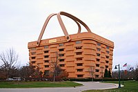
Newark is a city in, and the county seat of, Licking County, Ohio, United States; it is located 40 miles (64 km) east of Columbus at the junction of the forks of the Licking River. The population was 49,934 at the 2020 census, making it the 18th-largest city in Ohio. It is most known for having the world's largest basket, former headquarters of the now defunct Longaberger Company. The city is part of the Columbus metropolitan area.

<span class="mw-page-title-main">Pataskala, Ohio</span> City in Ohio, United States

Pataskala is a city in Licking County, Ohio, United States, approximately 19 miles (31 km) east of Columbus. The population was 17,886 at the 2020 census. Pataskala was a small community until 1996, when what was then the village of Pataskala merged with Lima Township, vastly increasing its population and geographic area.

<span class="mw-page-title-main">Buckeye Lake, Ohio</span> Village in Ohio, United States

Buckeye Lake is a village in Fairfield and Licking counties in the U.S. state of Ohio. The population was 2,520 at the 2020 census. It is named for Buckeye Lake, a large lake along which the village is built.

<span class="mw-page-title-main">Utica, Ohio</span> Village in Ohio, United States

Utica is a village in Knox and Licking counties in the U.S. state of Ohio, along the North Fork of the Licking River. The population was 2,064 at the 2020 census.

References

  1. "Ohio County Profiles: Licking County" (PDF). Ohio Department of Development. Archived from the original (PDF) on June 21, 2007. Retrieved April 28, 2007.
  2. 1 2 "State & County QuickFacts". United States Census Bureau. Retrieved October 21, 2022.
  3. "Find a County". National Association of Counties. Archived from the original on May 31, 2011. Retrieved June 7, 2011.
  4. Gannett, Henry (1905). The Origin of Certain Place Names in the United States. U.S. Government Printing Office. p.  186.
  5. Mahr, August C. (April 1957). "Indian River and Place Names in Ohio". Ohio Archaeological and Historical Quarterly. 66 (2): 146–148.
  6. "2010 Census Gazetteer Files". United States Census Bureau. August 22, 2012. Archived from the original on May 4, 2014. Retrieved February 8, 2015.
  7. "Annual Estimates of the Resident Population for Counties: April 1, 2020 to July 1, 2021" . Retrieved October 21, 2022.
  8. "U.S. Decennial Census". United States Census Bureau. Retrieved February 8, 2015.
  9. "Historical Census Browser". University of Virginia Library. Retrieved February 8, 2015.
  10. Forstall, Richard L., ed. (March 27, 1995). "Population of Counties by Decennial Census: 1900 to 1990". United States Census Bureau. Retrieved February 8, 2015.
  11. "Census 2000 PHC-T-4. Ranking Tables for Counties: 1990 and 2000" (PDF). United States Census Bureau. April 2, 2001. Archived (PDF) from the original on March 27, 2010. Retrieved February 8, 2015.
  12. "U.S. Census website". United States Census Bureau . Retrieved January 31, 2008.
  13. 1 2 3 "DP-1 Profile of General Population and Housing Characteristics: 2010 Demographic Profile Data". United States Census Bureau. Archived from the original on February 13, 2020. Retrieved December 27, 2015.
  14. "Population, Housing Units, Area, and Density: 2010 - County". United States Census Bureau. Archived from the original on February 13, 2020. Retrieved December 27, 2015.
  15. "DP02 SELECTED SOCIAL CHARACTERISTICS IN THE UNITED STATES – 2006-2010 American Community Survey 5-Year Estimates". United States Census Bureau. Archived from the original on February 13, 2020. Retrieved December 27, 2015.
  16. "DP03 SELECTED ECONOMIC CHARACTERISTICS – 2006-2010 American Community Survey 5-Year Estimates". United States Census Bureau. Archived from the original on February 13, 2020. Retrieved December 27, 2015.
  17. Leip, David. "Dave Leip's Atlas of U.S. Presidential Elections". uselectionatlas.org. Retrieved May 2, 2018.
  18. Williams, Mark; Trombly, Monroe (January 14, 2022). "What we know about Intel factory coming to Columbus area". The Columbus Dispatch .
  19. "The Velvet Ice Cream Company in Utica, Ohio". Archived from the original on June 1, 2007. Retrieved January 11, 2019.
  20. "Heisey Collectors of America". Heiseymuseum.org. Retrieved January 11, 2019.
  21. "National Trail Raceway" . Retrieved January 11, 2019.
  22. Ohio Townships

Further reading

40°05′N82°29′W / 40.09°N 82.48°W / 40.09; -82.48