Madison County, Ohio

Last updated

Madison County
London-ohio-courthouse.jpg
Flag of Madison County, Ohio.svg
Seal of Madison County Ohio.svg
Map of Ohio highlighting Madison County.svg
Location within the U.S. state of Ohio
Ohio in United States.svg
Ohio's location within the U.S.
Coordinates: 39°54′N83°24′W / 39.9°N 83.4°W / 39.9; -83.4
CountryFlag of the United States.svg United States
StateFlag of Ohio.svg  Ohio
FoundedFebruary 16, 1810 [1] [2]
Named for James Madison [3]
Seat London
Largest cityLondon
Area
  Total467 sq mi (1,210 km2)
  Land466 sq mi (1,210 km2)
  Water0.8 sq mi (2 km2)  0.2%
Population
 (2020)
  Total43,824
  Density94/sq mi (36/km2)
Time zone UTC−5 (Eastern)
  Summer (DST) UTC−4 (EDT)
Congressional district 15th
Website www.co.madison.oh.us

Madison County is a county located in the central portion of the U.S. state of Ohio. As of the 2020 census, the population was 43,824. [4] Its county seat is London. [5] The county is named for James Madison, President of the United States and was established on March 1, 1810. [6]

Contents

Madison County is part of the Columbus, OH Metropolitan Statistical Area.

History

In 1850, Madison County contained 24 churches and one newspaper office, had a total population of 10,015, and the county's public school system had 3838 pupils. [7] With agriculture as the primary business, that same year the county produced 726,451 bushels of corn, 19,308 tons of hay, 120,696 pounds of wool, and 128,948 pounds of butter. [7] In 1900, the county had a population of 20,590. [8]

In 2008, Madison County, which spans Interstates 70 and 71 as they converge on Columbus, was cited by the Ohio State Highway Patrol as leading the state for the most speeding tickets 20-mph or more over the posted limit. [9] Despite a population of around 42,000 in 2006, [10] over 7,700 such tickets were issued in three years. Three of Madison County's 18 fatal crashes in 2006 and 2007 occurred on interstates. [11] Madison County is also home to the Ohio Peace Officer Training Academy, the Ohio Bureau of Criminal Identification & Investigation, and several prison facilities. [12]

Geography

According to the U.S. Census Bureau, the county has a total area of 467 square miles (1,210 km2), of which 466 square miles (1,210 km2) is land and 0.8 square miles (2.1 km2) (0.2%) is water. [13]

Adjacent counties

Major highways

Demographics

Historical population
CensusPop.Note
1810 1,603
1820 4,799199.4%
1830 6,19029.0%
1840 9,02545.8%
1850 10,01511.0%
1860 13,01530.0%
1870 15,63320.1%
1880 20,12928.8%
1890 20,057−0.4%
1900 20,5902.7%
1910 19,902−3.3%
1920 19,662−1.2%
1930 20,2533.0%
1940 21,8117.7%
1950 22,3002.2%
1960 26,45418.6%
1970 28,3187.0%
1980 33,00416.5%
1990 37,06812.3%
2000 40,2138.5%
2010 43,4358.0%
2020 43,8240.9%
U.S. Decennial Census [14]
1790-1960 [15] 1900-1990 [16]
1990-2000 [17] 2020 [18]

2000 census

As of the census [19] of 2000, there were 40,213 people, 13,672 households, and 10,035 families living in the county. The population density was 86 inhabitants per square mile (33/km2). There were 14,399 housing units at an average density of 31 units per square mile (12/km2). The racial makeup of the county was 91.75% White, 6.24% Black or African American, 0.20% Native American, 0.44% Asian, 0.01% Pacific Islander, 0.35% from other races, and 1.01% from two or more races. 0.73% of the population were Hispanic or Latino of any race.

There were 13,672 households, out of which 35.20% had children under the age of 18 living with them, 59.20% were married couples living together, 9.90% had a female householder with no husband present, and 26.60% were non-families. 22.30% of all households were made up of individuals, and 9.50% had someone living alone who was 65 years of age or older. The average household size was 2.62 and the average family size was 3.06.

In the county, the population was spread out, with 24.70% under the age of 18, 9.10% from 18 to 24, 32.80% from 25 to 44, 22.60% from 45 to 64, and 10.90% who were 65 years of age or older. The median age was 36 years. For every 100 females there were 117.00 males. For every 100 females age 18 and over, there were 121.30 males.

The median income for a household in the county was $44,212, and the median income for a family was $50,520. Males had a median income of $35,251 versus $26,119 for females. The per capita income for the county was $18,721. About 6.20% of families and 7.80% of the population were below the poverty line, including 10.50% of those under age 18 and 8.70% of those age 65 or over.

2010 census

As of the 2010 United States Census, there were 43,435 people, 14,734 households, and 10,580 families living in the county. [20] The population density was 93.2 inhabitants per square mile (36.0/km2). There were 15,939 housing units at an average density of 34.2 units per square mile (13.2 units/km2). [21] The racial makeup of the county was 90.6% white, 6.6% black or African American, 0.5% Asian, 0.2% American Indian, 0.5% from other races, and 1.5% from two or more races. Those of Hispanic or Latino origin made up 1.4% of the population. [20] In terms of ancestry, 32.0% were German, 16.5% were Irish, 14.5% were American, and 9.6% were English. [22]

Of the 14,734 households, 34.1% had children under the age of 18 living with them, 55.4% were married couples living together, 11.3% had a female householder with no husband present, 28.2% were non-families, and 23.5% of all households were made up of individuals. The average household size was 2.59 and the average family size was 3.04. The median age was 39.1 years. [20]

The median income for a household in the county was $50,533 and the median income for a family was $63,397. Males had a median income of $46,550 versus $33,193 for females. The per capita income for the county was $23,980. About 8.9% of families and 11.7% of the population were below the poverty line, including 16.1% of those under age 18 and 6.1% of those age 65 or over. [23]

Politics

Madison County is a Republican stronghold county in presidential elections. The only two Democrats to win the county were Franklin D. Roosevelt in 1932 & 1936 and Lyndon B. Johnson in 1964.

United States presidential election results for Madison County, Ohio [24]
Year Republican Democratic Third party
No.%No.%No.%
2020 13,83569.57%5,69828.65%3541.78%
2016 11,63166.76%4,77927.43%1,0115.80%
2012 10,34258.91%6,84538.99%3702.11%
2008 10,60660.57%6,53237.30%3722.12%
2004 11,11763.90%6,20335.65%780.45%
2000 8,89260.63%5,28736.05%4883.33%
1996 6,87151.20%5,07237.79%1,47811.01%
1992 6,86548.79%3,99828.41%3,20822.80%
1988 8,30370.26%3,42128.95%930.79%
1984 8,97974.91%2,92824.43%800.67%
1980 7,16663.14%3,56531.41%6195.45%
1976 7,07458.17%4,88540.17%2021.66%
1972 8,37275.67%2,48422.45%2081.88%
1968 5,88257.15%2,78027.01%1,63115.85%
1964 4,94548.44%5,26451.56%00.00%
1960 7,25666.37%3,67733.63%00.00%
1956 6,48369.28%2,87530.72%00.00%
1952 6,27966.40%3,17733.60%00.00%
1948 4,73058.44%3,35641.46%80.10%
1944 5,54662.17%3,37437.83%00.00%
1940 5,90457.35%4,39042.65%00.00%
1936 4,84347.81%5,18451.17%1031.02%
1932 4,63149.13%4,72250.10%730.77%
1928 5,52268.13%2,52731.18%560.69%
1924 4,82961.97%2,68534.46%2783.57%
1920 5,39758.76%3,76941.03%190.21%
1916 2,80950.92%2,66748.35%400.73%
1912 2,27143.37%2,17241.48%79315.15%
1908 3,05154.93%2,43043.75%731.31%
1904 3,16459.07%2,10339.26%891.66%
1900 3,19755.58%2,49343.34%621.08%
1896 3,30854.01%2,75144.91%661.08%
1892 2,59450.93%2,29245.00%2074.06%
1888 2,70850.71%2,37644.49%2564.79%
1884 2,70652.28%2,39146.19%791.53%
1880 2,68053.09%2,30545.66%631.25%
1876 2,19150.24%2,14549.19%250.57%
1872 1,93454.25%1,62545.58%60.17%
1868 1,68252.04%1,55047.96%00.00%
1864 1,68858.94%1,17641.06%00.00%
1860 1,41753.03%1,01638.02%2398.94%
1856 99746.85%65630.83%47522.32%

Libraries

The following libraries serve the communities of Madison County.

Communities

Map of Madison County, Ohio with Municipal and Township Labels Map of Madison County Ohio With Municipal and Township Labels.PNG
Map of Madison County, Ohio with Municipal and Township Labels

City

Villages

Townships

Census-designated places

Unincorporated communities

See also

Related Research Articles

<span class="mw-page-title-main">Williams County, Ohio</span> County in Ohio, United States

Williams County is a county located in the U.S. state of Ohio. As of the 2020 census, the population was 37,102. Its county seat is Bryan. The county was created in 1820 and later organized in 1824. It is named for David Williams, one of the captors of John André in the American Revolutionary War.

<span class="mw-page-title-main">Van Wert County, Ohio</span> County in Ohio, United States

Van Wert County is a county located in the U.S. state of Ohio. As of the 2020 census, the population was 28,931. Its county seat is Van Wert. The county was created on February 12, 1820, and later organized on March 18, 1837. It is named for Isaac Van Wart, one of the captors of John André in the American Revolutionary War.

<span class="mw-page-title-main">Sandusky County, Ohio</span> County in Ohio, United States

Sandusky County is a county located in the northwestern part of the U.S. state of Ohio. As of the 2020 census, the population was 58,896. Its county seat and largest city is Fremont. The county was formed on February 12, 1820, from portions of Huron County.

<span class="mw-page-title-main">Richland County, Ohio</span> County in Ohio, United States

Richland County is a county located in the U.S. state of Ohio. As of the 2020 census, the population was 124,936. Its county seat is Mansfield. The county was created in 1808 and later organized in 1813. It is named for the fertile soil found there.

<span class="mw-page-title-main">Monroe County, Ohio</span> County in Ohio, United States

Monroe County is a county located on the eastern border of the U.S. state of Ohio, across the Ohio River from West Virginia. As of the 2020 census, the population was 13,385, making it the second-least populous county in Ohio. Its county seat is Woodsfield. The county was created in 1813 and later organized in 1815.

<span class="mw-page-title-main">Marion County, Ohio</span> County in Ohio, United States

Marion County is a county located in the U.S. state of Ohio. As of the 2020 census, the population was 65,359. Its county seat is Marion. The county was created in 1820 and later organized in 1824. It is named for General Francis "The Swamp Fox" Marion, a South Carolinian officer in the Revolutionary War.

<span class="mw-page-title-main">Licking County, Ohio</span> County in Ohio, United States

Licking County is a county located in the central portion of the U.S. state of Ohio. At the 2020 census, the population was 178,519. Its county seat is Newark. The county was formed on January 30, 1808, from portions of Fairfield County.

<span class="mw-page-title-main">Lake County, Ohio</span> County in Ohio, United States

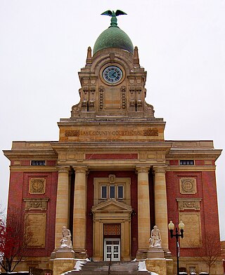
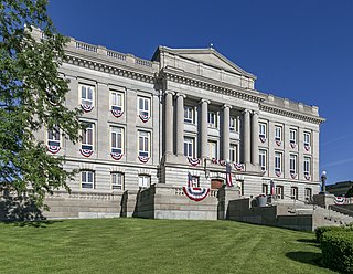
Lake County is a county in the U.S. state of Ohio. As of the 2020 census, the population was 232,603. Its county seat is Painesville, and its largest city is Mentor.

<span class="mw-page-title-main">Hardin County, Ohio</span> County in Ohio, United States

Hardin County is a county located in the west central portion of the U.S. state of Ohio. As of the 2020 census, the population was 30,696. Its county seat and largest city is Kenton. The county was created in 1820 and later organized in 1833. It is named for John Hardin, an officer in the American Revolution.

<span class="mw-page-title-main">Greene County, Ohio</span> County in Ohio, United States

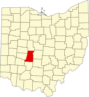
Greene County is located in the southwestern portion of Ohio. As of the 2020 census, the population was 167,966. Its county seat is Xenia and its largest city is Beavercreek. The county was established on March 24, 1803 and named for General Nathanael Greene, an officer in the Revolutionary War. Greene County is part of the Dayton, OH Metropolitan Statistical Area.

<span class="mw-page-title-main">Fulton County, Ohio</span> County in Ohio, United States

Fulton County is a county located in the U.S. state of Ohio west of Toledo. As of the 2020 census, the population was 42,713. Its county seat and largest city is Wauseon. The county was created in 1850 with land from Henry, Lucas, and Williams counties and is named for Robert Fulton, inventor of the steamboat. Fulton County is a part of the Toledo metropolitan area.

<span class="mw-page-title-main">Franklin County, Ohio</span> County in Ohio, United States

Franklin County is a county in the U.S. state of Ohio. As of the 2020 census, the population was 1,323,807, making it the most populous county in Ohio. Most of its land area is taken up by its county seat, Columbus, the state capital and most populous city in Ohio. The county was established on April 30, 1803, less than two months after Ohio became a state, and was named after Benjamin Franklin. Originally, Franklin County extended north to Lake Erie before it was subdivided into smaller counties. Franklin County is the central county of the Columbus, Ohio Metropolitan Statistical Area.

<span class="mw-page-title-main">Fayette County, Ohio</span> County in Ohio, United States

Fayette County is a county located in the U.S. state of Ohio. As of the 2020 census, the population was 28,951. Its county seat and largest city is Washington Court House. The county was named for the Marquis de Lafayette, a Frenchman who was an officer in the American Army in the Revolution, when established on March 1, 1810.

<span class="mw-page-title-main">Darke County, Ohio</span> County in Ohio, United States

Darke County is a county in the U.S. state of Ohio. As of the 2020 census, the population was 51,881. Its county seat and largest city is Greenville. The county was created in 1809 and later organized in 1817. It is named for William Darke, an officer in the American Revolutionary War. Darke County comprises the Greenville, OH Micropolitan Statistical Area, which is also included in the Dayton-Springfield-Sidney, OH Combined Statistical Area.

<span class="mw-page-title-main">Carroll County, Ohio</span> County in Ohio, United States

Carroll County is a county located in the state of Ohio. As of the 2020 census, the population was 26,721. Its county seat is Carrollton, while its largest village is Minerva. It is named for Charles Carroll of Carrollton, the last surviving signer of the Declaration of Independence.

Blacklick Estates is a census-designated place (CDP) in Franklin County, Ohio, United States: partly in Madison Township and partly in Truro Township. As of the 2020 census the population was 8,990.

<span class="mw-page-title-main">Madison, Ohio</span> Village in Ohio, United States

Madison is a village in Lake County, Ohio, United States. The population was 3,435 at the 2020 census.

<span class="mw-page-title-main">North Madison, Ohio</span> Census-designated place in Ohio, United States

North Madison is a census-designated place (CDP) comprising the unincorporated communities of Redbird and Madison-on-the-Lake in Lake County, Ohio, United States. The population was 8,188 at the 2020 census. The area uses a mailing address of "Madison", with the ZIP Code 44057.

<span class="mw-page-title-main">New Boston, Ohio</span> Village in Ohio, United States

New Boston is a village in Scioto County, Ohio, United States, along the Ohio River. The population was 2,298 at the 2020 census. Apart from its southern boundary on the Ohio River, New Boston is entirely surrounded by the city of Portsmouth.

<span class="mw-page-title-main">Cortland, Ohio</span> City in Ohio, United States

Cortland is a city in central Trumbull County, Ohio, United States. It lies on the eastern shore of Mosquito Creek Lake, 19 miles (31 km) north of Youngstown. The population was 7,105 at the 2020 census. It is part of the Youngstown–Warren metropolitan area.

References

  1. "Madison County Online Services". Madison County, Ohio. Archived from the original on March 7, 2011. Retrieved August 26, 2010.
  2. Williams, James (1887). The revised statutes of the state of Ohio, Volume 3. The Wrighton Printing Company. p. 583.
  3. Gannett, Henry (1905). The Origin of Certain Place Names in the United States. U.S. Government Printing Office. p.  196.
  4. "2020 Population and Housing State Data". Census.gov. Retrieved January 12, 2022.
  5. "Find a County". National Association of Counties. Archived from the original on May 31, 2011. Retrieved June 7, 2011.
  6. "Madison County data". Ohio State University Extension Data Center. Retrieved April 28, 2007.[ dead link ]
  7. 1 2 Thomas Baldwin & J. Thomas, A new and complete gazetteer of the United States , Lippincott, Grambo & Co, 1854, Pg. 643
  8. Stella Shoemaker Wilson, Ohio , Macmillan, 1902, Pg. 97
  9. "AGGRESSIVE DRIVING: 20mph+ Over the Speed Limit", Ohio State Highway Patrol, Traffic Safety Bulletin, February 13, 2008. "Archived copy" (PDF). Archived from the original (PDF) on April 8, 2008. Retrieved February 17, 2008.{{cite web}}: CS1 maint: archived copy as title (link), retrieved February 17, 2008
  10. U.S. Census Quick Facts : Madison County, Ohio "Madison County QuickFacts from the US Census Bureau". Archived from the original on June 6, 2011. Retrieved July 6, 2011., retrieved February 17, 2008
  11. "Madison County Fatal Crashes, 2006-2008", Ohio State Highway Patrol, "Archived copy" (PDF). Archived from the original (PDF) on April 8, 2008. Retrieved February 17, 2008.{{cite web}}: CS1 maint: archived copy as title (link), retrieved February 17, 2008
  12. "No radar needed in Ohio", Motor Trend , retrieved May 25, 2011
  13. "2010 Census Gazetteer Files". United States Census Bureau. August 22, 2012. Archived from the original on May 4, 2014. Retrieved February 9, 2015.
  14. "U.S. Decennial Census". United States Census Bureau. Retrieved February 9, 2015.
  15. "Historical Census Browser". University of Virginia Library. Retrieved February 9, 2015.
  16. Forstall, Richard L., ed. (March 27, 1995). "Population of Counties by Decennial Census: 1900 to 1990". United States Census Bureau. Retrieved February 9, 2015.
  17. "Census 2000 PHC-T-4. Ranking Tables for Counties: 1990 and 2000" (PDF). United States Census Bureau. April 2, 2001. Archived (PDF) from the original on March 27, 2010. Retrieved February 9, 2015.
  18. 2020 census
  19. "U.S. Census website". United States Census Bureau . Retrieved January 31, 2008.
  20. 1 2 3 "DP-1 Profile of General Population and Housing Characteristics: 2010 Demographic Profile Data". United States Census Bureau. Archived from the original on February 13, 2020. Retrieved December 27, 2015.
  21. "Population, Housing Units, Area, and Density: 2010 - County". United States Census Bureau. Archived from the original on February 13, 2020. Retrieved December 27, 2015.
  22. "DP02 SELECTED SOCIAL CHARACTERISTICS IN THE UNITED STATES – 2006-2010 American Community Survey 5-Year Estimates". United States Census Bureau. Archived from the original on February 13, 2020. Retrieved December 27, 2015.
  23. "DP03 SELECTED ECONOMIC CHARACTERISTICS – 2006-2010 American Community Survey 5-Year Estimates". United States Census Bureau. Archived from the original on February 13, 2020. Retrieved December 27, 2015.
  24. Leip, David. "Dave Leip's Atlas of U.S. Presidential Elections". uselectionatlas.org. Retrieved May 2, 2018.

39°54′N83°24′W / 39.90°N 83.40°W / 39.90; -83.40