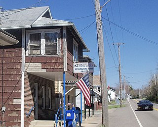
Kensington is an unincorporated community in southwestern Hanover Township, Columbiana County, Ohio, United States. Lying along U.S. Route 30 at its intersection with Ohio State Routes 9 and 644, it has a post office with the ZIP code 44427. Kensington is a part of the Salem micropolitan area, 23 miles (37 km) miles east of Canton and 30 miles (48 km) southwest of Youngstown.
Chenoweth is an unincorporated community in Range Township, Madison County, Ohio, United States. It is located along Ohio State Route 323 between McClimansville and Range.
Kiousville is an unincorporated community in southern Fairfield Township, Madison County, Ohio, United States. It is located at the intersection of Kiousville-Georgesville Road and McKendree Road.
Jerome is an unincorporated community in Jerome Township, Union County, Ohio, United States. It is located at 40°09′59″N83°10′33″W, at the intersection of Jerome Road and Scioto Road, about 2 miles east of New California.
Saint Charles is an unincorporated community in Butler County, in the U.S. state of Ohio.
Calumet is an unincorporated community in Knox Township, Jefferson County, Ohio, United States. It is located just north of Toronto between Ohio State Route 7 and the Ohio River, at 40°28′55″N80°36′24″W. North 4th Street and North River Avenue both run continuously from Toronto to Calumet.
Afton is an unincorporated community in Clermont County, in the U.S. state of Ohio.
Glen Roy is an unincorporated community in Coal Township, Jackson County, Ohio, United States. It is located east of Coalton along Ohio State Route 93, between Altoona and Goldsboro, at 39°06′45″N82°34′47″W.
Stanhope is an unincorporated community in Ashtabula and Trumbull counties, in the U.S. state of Ohio.
Limerick is an unincorporated community in Jackson Township, Jackson County, Ohio, United States. It is located at 39°07′29″N82°44′58″W.
Chapman is an unincorporated community in Coal Township, Jackson County, Ohio, United States. It is located south of Coalton at 39°05′21″N82°37′06″W, at the intersection of Ohio State Route 93 and Jackson Hill Road.
Keystone is an unincorporated community in Bloomfield Township, Jackson County, Ohio, United States. It is located south of the city of Jackson, at the intersection of Franklin Valley Road and Keystone Station Road, at 38°59′17″N82°36′33″W.
Clay is an unincorporated community in Franklin Township, Jackson County, Ohio, United States. It is located between Jackson and Oak Hill at the intersection of Ohio State Route 93 and Clay Banner Road/Pyro Road.
Banner is an unincorporated community in Franklin Township, Jackson County, Ohio, United States. It is located between Jackson and Oak Hill near the intersection of Clay Banner Road and Franklin Valley Road.
Kitchen is an unincorporated community in Madison Township, Jackson County, Ohio, United States. It is located southeast of Oak Hill at the intersection of Ohio State Route 233 and CH&D Road, at 38°52′11″N82°32′34″W.
Mabee Corner is an unincorporated community in Hamilton Township, Jackson County, Ohio, United States. It is located west of Oak Hill at the intersection of Bucklick Creek Road and Ohio State Route 139, at 38°54′10″N82°43′16″W.
Broadacre is an unincorporated community in Wayne Township, Jefferson County, Ohio, United States. It is located about 2.5 miles (4.0 km) northeast of Bloomingdale at the intersection of Ohio State Route 152 and Township Route 166, at 40°21′58″N80°46′59″W.
Chandler is an unincorporated community in Wayne Township, Jefferson County, Ohio, United States. It is located south of Bloomingdale at the intersection of Bloomingdale-Smithfield-Chandler Road and County Road 24, at 40°18′28″N80°48′15″W.
Holt is an unincorporated community in Knox Township, Jefferson County, Ohio, United States. It is located about 3 miles (4.8 km) west of New Somerset at the intersection of County Highway 53 and Township Road 218, at 40°30′44″N80°45′06″W.
Robyville is an unincorporated community in Smithfield Township, Jefferson County, Ohio, United States. It is located southwest of Adena on Hanna Avenue, at 40°12′25″N80°52′45″W.

