
Rosedale is an unincorporated community in central Pike Township, Madison County, Ohio, United States, and roughly thirty miles west of the city of Columbus.
Amity is an unincorporated community in north-eastern Canaan Township, Madison County, Ohio, United States. It is located at the intersection of Plain City-Georgesville Road and Amity Pike Road, between Plain City and West Jefferson.
Chenoweth is an unincorporated community in Range Township, Madison County, Ohio, United States. It is located along Ohio State Route 323 between McClimansville and Range.
Range is an unincorporated community in Range Township, Madison County, Ohio, United States. It is located between Chenoweth and Midway.

Lafayette is a census-designated place in the center of Deer Creek Township, Madison County, Ohio, United States. It is located along U.S. Route 40, just west of its intersection with U.S. Route 42. The population of Lafayette was 206 at the 2020 census.
Lilly Chapel is an unincorporated community in Fairfield Township, Madison County, Ohio, United States. It is located at the intersection of W. Jefferson Kiousville Road and Lilly Chapel Georgesville Road, approximately three miles west of Georgesville.
Rupert is an unincorporated community in Union Township, Madison County, Ohio, United States. It is located at the intersection of Ohio State Route 665 and Glade Run Road, approximately four miles east of London.
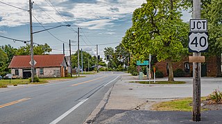
Summerford is an unincorporated community in Somerford Township, Madison County, Ohio, United States. It is located at the intersection of U.S. Route 40 and State Route 56.
Newport is an unincorporated community in Paint Township, Madison County, Ohio, United States. It is located along Ohio State Route 38 between London and Midway.
Resaca is an unincorporated community in Monroe Township, Madison County, Ohio, United States. It is located at the intersection of Finley Guy Road and Woods and W Avenue.
Tradersville is an unincorporated community in Somerford Township, Madison County, Ohio, United States.

Big Plain is an unincorporated community in Fairfield Township, Madison County, Ohio, United States. It is located at the intersection of West Jefferson-Kiousville Road and Big Plain-Circleville Road, approximately four miles north of Kiousville.
Wrightsville is an unincorporated community in Fairfield Township, Madison County, Ohio, United States. It is located at 39°51′40″N83°14′50″W, at the intersection of Ohio State Route 665 and Georgesville-Wrightsville Road, approximately four miles north of Kiousville. Some national maps mistakenly show Wrightsville in Franklin County.

Byhalia is an unincorporated community in Washington Township, Union County, Ohio, United States. It is located at 40°27′13″N83°27′20″W, at the intersection of State Routes 31 and 739.

Madison Mills is an unincorporated community in Madison Township, Fayette County, Ohio, United States. It is located at 39°39′13″N83°20′23″W, along Harrison Road, between Bloomingburg and Mount Sterling.
Chrisman is an unincorporated community in Oak Run Township, Madison County, Ohio, United States. It is located at the intersection of London-Circleville Road and Gregg Mill Road, about four miles southeast of London.
Chapman is an unincorporated community in Coal Township, Jackson County, Ohio, United States. It is located south of Coalton at 39°05′21″N82°37′06″W, at the intersection of Ohio State Route 93 and Jackson Hill Road.
Kitchen is an unincorporated community in Madison Township, Jackson County, Ohio, United States. It is located southeast of Oak Hill at the intersection of Ohio State Route 233 and CH&D Road, at 38°52′11″N82°32′34″W.
Mabee Corner is an unincorporated community in Hamilton Township, Jackson County, Ohio, United States. It is located west of Oak Hill at the intersection of Bucklick Creek Road and Ohio State Route 139, at 38°54′10″N82°43′16″W.
Firebrick is an unincorporated community in Washington Township, Lawrence County, Ohio, United States. It is located between Oak Hill and South Webster near the intersection of Ohio State Route 140 and Blackfork-Firebrick Road, at 38°50′21″N82°38′44″W.

