Choctaw Lake, Ohio

Last updated
Choctaw Lake, Ohio
CDP
Lake Choctaw, Ohio- 9-8-2019.jpg
Sign at the entrance of the Choctaw Lake community
OHMap-doton-Choctaw Lake.png
Location of Choctaw Lake, Ohio
Coordinates: 39°57′39″N83°29′15″W / 39.96083°N 83.48750°W / 39.96083; -83.48750
Country United States
State Ohio
County Madison
Area
[1]
  Total1.44 sq mi (3.74 km2)
  Land1.04 sq mi (2.69 km2)
  Water0.41 sq mi (1.06 km2)
Elevation
[2]
1,053 ft (321 m)
Population
 (2020)
  Total2,047
  Density1,973.96/sq mi (761.80/km2)
Time zone UTC-5 (Eastern (EST))
  Summer (DST) UTC-4 (EDT)
FIPS code 39-14288 [3]
GNIS feature ID2393377 [2]
Website choctawlake.com

Choctaw Lake is a census-designated place (CDP) in Madison County, Ohio, United States. The population was 2,047 at the 2020 census.

Contents

Geography

According to the United States Census Bureau, the CDP has a total area of 1.2 square miles (3.1 km2), of which 0.8 square miles (2.1 km2) is land and 0.4 square miles (1.0 km2) (33.33%) is water.

Demographics

Historical population
CensusPop.Note
2020 2,047
U.S. Decennial Census [4]

As of the census [3] of 2000, there were 1,562 people, 581 households, and 493 families residing in the CDP. The population density was 1,946.0 inhabitants per square mile (751.4/km2). There were 623 housing units at an average density of 776.2 per square mile (299.7/km2). The racial makeup of the CDP was 95.65% White, 0.26% African American, 0.19% Native American, 2.75% Asian, 0.45% from other races, and 0.70% from two or more races. Hispanic or Latino of any race were 0.51% of the population.

There were 581 households, out of which 36.5% had children under the age of 18 living with them, 78.8% were married couples living together, 3.8% had a female householder with no husband present, and 15.0% were non-families. 11.2% of all households were made up of individuals, and 3.4% had someone living alone who was 65 years of age or older. The average household size was 2.69 and the average family size was 2.91.

In the CDP the population was spread out, with 25.4% under the age of 18, 4.1% from 18 to 24, 32.6% from 25 to 44, 30.7% from 45 to 64, and 7.2% who were 65 years of age or older. The median age was 39 years. For every 100 females there were 102.6 males. For every 100 females age 18 and over, there were 98.3 males.

The median income for a household in the CDP was $81,644, and the median income for a family was $86,670. Males had a median income of $47,652 versus $40,588 for females. The per capita income for the CDP was $30,624. About 4.0% of families and 6.9% of the population were below the poverty line, including 15.1% of those under age 18 and none of those age 65 or over.

Related Research Articles

<span class="mw-page-title-main">Blue Ridge, Alabama</span> Census-designated place in Alabama, United States

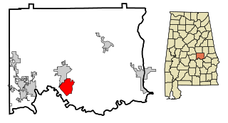
Blue Ridge is an unincorporated community and census-designated place (CDP) in Elmore County, Alabama, United States. At the 2020 census, the population was 1,485. It is part of the Montgomery Metropolitan Statistical Area.

<span class="mw-page-title-main">Lake Nacimiento, California</span> Census-designated place in California, United States

Lake Nacimiento is a census-designated place (CDP) in northern San Luis Obispo County, California, United States.

<span class="mw-page-title-main">West Samoset, Florida</span> Census-designated place in Florida, United States

West Samoset is an unincorporated area and census-designated place (CDP) in Manatee County, Florida, United States. The population was 6,482 at the 2020 census, up from 5,583 in 2010. It is part of the Bradenton–Sarasota–Venice Metropolitan Statistical Area.

<span class="mw-page-title-main">Waverly, Florida</span> Census-designated place in Florida, United States

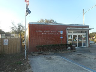
Waverly is a census-designated place (CDP) in east-central Polk County, Florida, United States. The population was 1,927 at the 2000 census. It is part of the Lakeland–Winter Haven Metropolitan Statistical Area.

<span class="mw-page-title-main">Natalbany, Louisiana</span> CDP in Louisiana, United States

Natalbany is a census-designated place (CDP) in Tangipahoa Parish, Louisiana, United States. The population was 1,739 at the 2000 census. It is part of the Hammond Micropolitan Statistical Area.

<span class="mw-page-title-main">Naval Academy, Maryland</span> Census-designated place in Maryland, United States

Naval Academy is a census-designated place (CDP) in Anne Arundel County, Maryland, United States, which covers the campus of the United States Naval Academy. The population was 4,802 at the 2010 census.

<span class="mw-page-title-main">Standing Pine, Mississippi</span> Census-designated place in Mississippi, United States

Standing Pine is a census-designated place (CDP) in Leake County, Mississippi, United States. It is one of the eight communities of the Mississippi Band of Choctaw Indians Reservation, and the population is 94% Choctaw. The total population of the CDP was 517 at the 2020 census.

<span class="mw-page-title-main">Pearl River, Mississippi</span> CDP in Mississippi, United States

Pearl River is a census-designated place (CDP) in Neshoba County, Mississippi. It is one of the eight communities of the Mississippi Band of Choctaw Indians Reservation and the population is 80% Choctaw. The population was 3,156 at the 2000 census.

<span class="mw-page-title-main">Tucker, Mississippi</span> CDP in Mississippi, United States

Tucker is a census-designated place (CDP) in Neshoba County, Mississippi. It is one of the eight communities of the Mississippi Band of Choctaw Indians Reservation and the population is 93% Choctaw. The population was 642 at the 2020 census.

<span class="mw-page-title-main">Conehatta, Mississippi</span> CDP in Mississippi, United States

Conehatta is a census-designated place (CDP) in Newton County, Mississippi. The population was 997 at the 2000 census. It is one of the eight communities included in the Mississippi Band of Choctaw Indians Reservation and the population is 76% Choctaw.

<span class="mw-page-title-main">Cricket, North Carolina</span> CDP in North Carolina, United States

Cricket is a census-designated place (CDP) located between Wilkesboro and North Wilkesboro in Wilkes County, North Carolina, United States. The population was 2,053 at the 2000 census.

<span class="mw-page-title-main">Longtown, Oklahoma</span> CDP in Oklahoma, United States

Longtown is a census-designated place (CDP) and unincorporated community in Pittsburg County, Oklahoma, United States. The population was 2,397 at the 2000 census.

<span class="mw-page-title-main">West Hills, Pennsylvania</span> Census-designated place in Pennsylvania, United States

West Hills is a census-designated place (CDP) in Armstrong County, Pennsylvania, United States. The population was 1,228 at the 2020 census.

<span class="mw-page-title-main">Green Valley, South Dakota</span> CDP in South Dakota, United States

Green Valley is a census-designated place (CDP) and unincorporated community in Pennington County, South Dakota, United States. The population was 1,051 at the 2020 census.

<span class="mw-page-title-main">Coal Fork, West Virginia</span> Census-designated place in West Virginia, United States

Coal Fork is an unincorporated census-designated place (CDP) in Kanawha County, West Virginia, United States. It is part of a larger unincorporated community known as Campbells Creek, approximately 10 minutes east of Charleston. The population was 1,233 at the 2010 census.

<span class="mw-page-title-main">Red Jacket, West Virginia</span> Census-designated place in West Virginia, United States

Red Jacket is a census-designated place (CDP) in Mingo County, West Virginia, United States. The population was 581 at the 2010 census. The community was named for Red Jacket, a Seneca chief.

<span class="mw-page-title-main">Boaz, West Virginia</span> CDP in West Virginia, United States

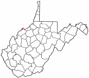
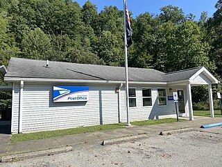
Boaz is a census-designated place (CDP) in Wood County, West Virginia, United States. It is part of the Parkersburg-Marietta-Vienna, WV-OH Metropolitan Statistical Area. As of the 2020 census, the CDP population was 1,321.

<span class="mw-page-title-main">Bogue Chitto, Mississippi</span> Census-designated place in Mississippi, United States

Bogue Chitto is a census-designated place (CDP) situated in Kemper and Neshoba counties, Mississippi. The population was 864 at the 2020 census. It is part of the Mississippi Band of Choctaw Indians Reservation and the population is 93% Choctaw.

<span class="mw-page-title-main">Essex (CDP), Massachusetts</span> Census-designated place in Massachusetts, United States

Essex CDP is a census-designated place (CDP) in the town of Essex in Essex County, Massachusetts, United States. The population was 1,471 at the 2010 census.

<span class="mw-page-title-main">Dixfield (CDP), Maine</span> CDP in Maine, United States

Dixfield is a census-designated place (CDP) in the town of Dixfield in Oxford County, Maine, United States. The population was 1,323 at the 2020 census.

References

  1. "ArcGIS REST Services Directory". United States Census Bureau. Retrieved September 20, 2022.
  2. 1 2 U.S. Geological Survey Geographic Names Information System: Choctaw Lake, Ohio
  3. 1 2 "U.S. Census website". United States Census Bureau . Retrieved 2008-01-31.
  4. "Census of Population and Housing". Census.gov. Retrieved June 4, 2016.