Midway, Ohio

Last updated

Midway, Ohio
Range Township fire department.jpg
Fire department downtown
OHMap-doton-Midway.png
Location of Midway, Ohio
Map of Madison County Ohio Highlighting Midway Village.png
Location of Midway in Madison County
Coordinates: 39°43′59″N83°28′36″W / 39.73306°N 83.47667°W / 39.73306; -83.47667
Country United States
State Ohio
County Madison
Area
[1]
  Total0.26 sq mi (0.67 km2)
  Land0.26 sq mi (0.67 km2)
  Water0.00 sq mi (0.00 km2)
Elevation
[2]
1,070 ft (330 m)
Population
 (2020)
  Total269
  Density1,034.62/sq mi (399.81/km2)
Time zone UTC-5 (Eastern (EST))
  Summer (DST) UTC-4 (EDT)
FIPS code 39-50008 [3]
GNIS feature ID2399339 [2]

Midway (also called Sedalia) is a village in Range Township, Madison County, Ohio, United States. The population was 269 at the 2020 census.

Contents

Midway is also called "Sedalia" by some sources. [4] Addresses with its ZIP code, 43151, are officially located in Sedalia. [5]

History

Midway was laid out by F. Thompson and William Morris, and recorded June 13, 1830. The community was named Midway for its location at the half-way point on a cattle route between Chicago and Philadelphia. [6] [7] As of 1875, the community contained two churches, three dry goods stores, one hotel, one blacksmith shop, one wagon shop, one shoe shop, one physician, and the population was 250. [8]

Geography

Midway is located at the intersection of Ohio State Routes 38 and 323. [9]

According to the United States Census Bureau, the village has a total area of 0.29 square miles (0.75 km2), all land. [10]

Demographics

Historical population
CensusPop.Note
1900 274
1910 48376.3%
1920 301−37.7%
1930 3175.3%
1940 278−12.3%
1950 276−0.7%
1960 34123.6%
1970 318−6.7%
1980 3396.6%
1990 289−14.7%
2000 274−5.2%
2010 32217.5%
2020 269−16.5%
U.S. Decennial Census [11]

2010 census

As of the census [12] of 2010, there were 322 people, 116 households, and 89 families living in the village. The population density was 1,110.3 inhabitants per square mile (428.7/km2). There were 127 housing units at an average density of 437.9 per square mile (169.1/km2). The racial makeup of the village was 97.2% White, 0.9% African American, 0.6% Native American, and 1.2% from two or more races. Hispanic or Latino of any race were 3.1% of the population.

There were 116 households, of which 43.1% had children under the age of 18 living with them, 48.3% were married couples living together, 19.8% had a female householder with no husband present, 8.6% had a male householder with no wife present, and 23.3% were non-families. 16.4% of all households were made up of individuals, and 6.9% had someone living alone who was 65 years of age or older. The average household size was 2.78 and the average family size was 3.04.

The median age in the village was 34.7 years. 30.7% of residents were under the age of 18; 9.9% were between the ages of 18 and 24; 20.8% were from 25 to 44; 26.6% were from 45 to 64; and 11.8% were 65 years of age or older. The gender makeup of the village was 48.8% male and 51.2% female.

2000 census

As of the census [3] of 2000, there were 274 people, 110 households, and 85 families living in the village. The population density was 984.9 inhabitants per square mile (380.3/km2). There were 122 housing units at an average density of 438.5 per square mile (169.3/km2). The racial makeup of the village was 99.64% White, and 0.36% from two or more races. Hispanic or Latino of any race were 1.46% of the population.

There were 110 households, out of which 38.2% had children under the age of 18 living with them, 60.9% were married couples living together, 10.0% had a female householder with no husband present, and 22.7% were non-families. 22.7% of all households were made up of individuals, and 13.6% had someone living alone who was 65 years of age or older. The average household size was 2.49 and the average family size was 2.91.

In the village, the population was spread out, with 28.1% under the age of 18, 4.7% from 18 to 24, 24.8% from 25 to 44, 25.9% from 45 to 64, and 16.4% who were 65 years of age or older. The median age was 38 years. For every 100 females there were 91.6 males. For every 100 females age 18 and over, there were 93.1 males.

The median income for a household in the village was $39,464, and the median income for a family was $42,500. Males had a median income of $34,167 versus $25,714 for females. The per capita income for the village was $17,990. About 2.2% of families and 3.0% of the population were below the poverty line, including none of those under the age of eighteen and 10.9% of those 65 or over.

Notable person

Related Research Articles

<span class="mw-page-title-main">Fort Shawnee, Ohio</span> CDP in Ohio, United States

Fort Shawnee is census-designated place (CDP) in Allen County, Ohio, United States. The population was 6,263 at the 2020 census. It is included in the Lima, Ohio Metropolitan Statistical Area. Fort Shawnee is adjacent to the city of Lima and the village of Cridersville in Auglaize County. In 2012, village residents voted to disincorporate the village. According to the United States Census Bureau, the village had a total area of 7.25 square miles (18.78 km2), of which 7.21 square miles (18.67 km2) is land and 0.04 square miles (0.10 km2) is water.

<span class="mw-page-title-main">Hamersville, Ohio</span> Village in Ohio, United States

Hamersville is a village in Clark Township, Brown County, Ohio, United States. The population was 485 at the 2020 census.

<span class="mw-page-title-main">Mutual, Ohio</span> Village in Ohio, United States

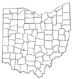
Mutual is a village in Champaign County, Ohio, United States. The population was 127 at the 2020 census.

<span class="mw-page-title-main">Ithaca, Ohio</span> Village in Ohio, United States

Ithaca is a village in Darke County, Ohio, United States. The population was 81 at the 2020 census.

<span class="mw-page-title-main">Sugar Grove, Ohio</span> Village in Ohio, United States

Sugar Grove is a village in Fairfield County, Ohio, United States. The population was 429 at the 2020 census.

<span class="mw-page-title-main">Lyons, Ohio</span> Village in Ohio, United States

Lyons is a village in Fulton County, Ohio, United States. The population was 602 at the 2020 census.

<span class="mw-page-title-main">Cleves, Ohio</span> City in Ohio, United States

Cleves is a village in Miami Township, Hamilton County, Ohio, United States. Located along the Ohio River, it is a western suburb of Cincinnati. The population was 3,414 at the 2020 census.

<span class="mw-page-title-main">Mowrystown, Ohio</span> Village in Ohio, United States

Mowrystown is a village in Highland County, Ohio, United States. The population was 385 at the 2020 census.

<span class="mw-page-title-main">Hebron, Ohio</span> Village in Ohio, USA

Hebron is a village in Licking County, Ohio, United States. The population was 2,326 at the 2020 census.

<span class="mw-page-title-main">South Solon, Ohio</span> Village in Ohio, United States

South Solon is a village in Madison County, Ohio, United States. The population was 329 at the 2020 census. Despite their similar names, South Solon is not adjacent to the city of Solon, Ohio, a suburb of Cleveland in Cuyahoga County. The two towns are approximately 170 miles (270 km) apart.

<span class="mw-page-title-main">Spencer, Ohio</span> Village in Ohio, United States

Spencer is a village in Spencer Township located in Medina County, Ohio, United States. The population was 684 at the 2020 census.

<span class="mw-page-title-main">Jerusalem, Ohio</span> Village in Ohio, United States

Jerusalem is a village in Monroe County, Ohio, United States. The population was 121 at the 2020 census.

<span class="mw-page-title-main">Batesville, Ohio</span> Village in Ohio, United States

Batesville is a village in Noble County, Ohio, United States. The population was 101 at the 2020 census. Batesville was originally called Williamsburg, and under the latter name was laid out in 1827.

<span class="mw-page-title-main">Haviland, Ohio</span> Village in Ohio, United States

Haviland is a village in Paulding County, Ohio, United States. The population was 160 at the 2020 census.

<span class="mw-page-title-main">Tarlton, Ohio</span> Village in Ohio, United States

Tarlton is a village in Fairfield and Pickaway counties in the U.S. state of Ohio. The population was 254 at the 2020 census.

<span class="mw-page-title-main">Cloverdale, Ohio</span> Village in Ohio, United States

Cloverdale is a village in Perry Township, Putnam County, Ohio, United States. The population was 170 at the 2020 census.

<span class="mw-page-title-main">Port Jefferson, Ohio</span> Village in Ohio, United States

Port Jefferson is a village in Salem Township, Shelby County, Ohio, United States. The population was 308 at the 2020 census.

<span class="mw-page-title-main">Limaville, Ohio</span> Census-designated place in Ohio, United States

Limaville is a census-designated place (CDP) and former village in Stark County, Ohio, United States. The population was 151 at the 2020 census. It is part of the Canton–Massillon Metropolitan Statistical Area.

<span class="mw-page-title-main">Wilkesville, Ohio</span> Village in Ohio, United States

Wilkesville is a village in Vinton County, Ohio, United States. The population was 116 at the 2020 census.

<span class="mw-page-title-main">Congress, Ohio</span> Village in Ohio, United States

Congress is a village in Wayne County, Ohio, United States. The population was 132 at the 2020 census.

References

  1. "ArcGIS REST Services Directory". United States Census Bureau. Retrieved September 20, 2022.
  2. 1 2 U.S. Geological Survey Geographic Names Information System: Midway, Ohio
  3. 1 2 "U.S. Census website". United States Census Bureau . Retrieved January 31, 2008.
  4. Midway, Ohio (OH), United States AllRefer.com — Midway, Ohio (OH), United States, Columbia Gazetteer of North America, Columbia University Press, 2000; website 2005. Accessed October 3, 2007.
  5. 43151 Zip Code (Midway, Ohio) Detailed Profile, City-data.com, 2007. Accessed October 3, 2007.
  6. Overman, William Daniel (1958). Ohio Town Names. Akron, OH: Atlantic Press. p. 87.
  7. Peacefull, Leonard (1996). A Geography of Ohio. Kent State University Press. p. 217. ISBN   9780873385251 . Retrieved December 8, 2013.
  8. J. A. Caldwell, Caldwell's Atlas of Madison County, Ohio , Condit, Ohio, 1875, Pg. 10.
  9. "US Gazetteer files: 2010, 2000, and 1990". United States Census Bureau. February 12, 2011. Retrieved April 23, 2011.
  10. "US Gazetteer files 2010". United States Census Bureau . Retrieved January 6, 2013.
  11. "Census of Population and Housing". Census.gov. Retrieved June 4, 2015.
  12. "U.S. Census website". United States Census Bureau . Retrieved January 6, 2013.