Mercer County, Ohio

Last updated

Mercer County
Mercer County Courthouse Celina Ohio.JPG
Mercer County courthouse
Flag of Mercer County, Ohio.svg
Seal of Mercer County Ohio.svg
Map of Ohio highlighting Mercer County.svg
Location within the U.S. state of Ohio
Ohio in United States.svg
Ohio's location within the U.S.
Coordinates: 40°32′N84°38′W / 40.54°N 84.63°W / 40.54; -84.63
CountryFlag of the United States.svg United States
StateFlag of Ohio.svg  Ohio
FoundedJanuary 2, 1824
Named for Hugh Mercer
Seat Celina
Largest cityCelina
Area
  Total473 sq mi (1,230 km2)
  Land462 sq mi (1,200 km2)
  Water11 sq mi (30 km2)  2.3%
Population
 (2020)
  Total42,528 Increase2.svg
  Density90/sq mi (30/km2)
Time zone UTC−5 (Eastern)
  Summer (DST) UTC−4 (EDT)
Congressional district 5th
Website www.mercercountyohio.org
Grand Lake St. Marys State Park Celina-ohio-grand-lake.jpg
Grand Lake St. Marys State Park
Graftonoceras fossil nautiloid, found near Coldwater, southern Mercer County. Graftonoceras fossil nautiloid (Lockport Dolomite, Middle Silurian; Coldwater, southern Mercer County, western Ohio, USA) (15054984258).jpg
Graftonoceras fossil nautiloid, found near Coldwater, southern Mercer County.

Mercer County is located in the U.S. state of Ohio. As of the 2020 census, the population was 42,528. [1] Its county seat is Celina. [2] The county was created in 1820 and later organized in 1824. [3] It is named for Hugh Mercer, an officer in the American Revolutionary War. [4]

Contents

Mercer County comprises the Celina, Ohio Micropolitan Statistical Area

History

Mercer County was created in 1820 from land that had been attached to Darke and Shelby counties. Land south of the Greenville Treaty Line was still part of Darke County. An act establishing and fully organizing Mercer County took place on January 2, 1824. In 1837 Van Wert County was detached and the county line established is the current northern border of Mercer County. In 1839 Celina was established as the seat of Mercer County; St. Marys was the previous seat. In 1848 the area south of the Greenville Treaty Line to the current southern county line, was attached. When Auglaize County was formed, Mercer County's eastern border was moved 6 miles (9.7 km) west with the exception of the area south of the Greenville Treaty Line. This created the sharp point at Mercer County's southeast corner and was the last county line modification.

In the mid to late 1800s, Mercer County became home to many German immigrant farming families. Many of these German Americans had immigrated from northwestern Germany.

Geography

According to the U.S. Census Bureau, the county has a total area of 473 square miles (1,230 km2), of which 462 square miles (1,200 km2) is land and 11 square miles (28 km2) (2.3%) is water. [5] The entire county has an elevation difference of less than 300 feet. The highest point is on the southern county line at 1071 feet above sea level. This is in proximity to the head waters for the Wabash River. The lowest point in the county is 780 feet above sea level. This point is located on the northern county line where the St. Marys River crosses over.

Drainage basins

Mercer County has two rivers running through it; the Wabash and the St. Marys. The Wabash watershed is part of the Gulf of Mexico's watershed. The St. Marys watershed is part of Lake Erie's watershed. Creeks between these two watersheds are within a mile of each other at some places in Mercer County. The summit line that divides the drainage basins is known as the St. Lawrence Continental Divide

Beaver Creek

Beaver Creek is the longest and largest creek in Mercer County. It stretches 19.7 miles and has two sections. The first section begins in southern farmland in the county and flows through the town of Montezuma, Ohio and into Grand Lake St. Marys. The other section of the creek begins as a spillway and empties into the Wabash River. Beaver Creek was originally one piece, but was split into two sections after the construction of Grand Lake. The creeks' spillway, and last section, has been the subject of controversy and multimillion-dollar lawsuits. Farmers along Beaver Creek claim their land floods because of the spillway that was put up in 1997, replacing the previous spillway, built in 1913. [6]

Government

Mercer County has a 3-member Board of County Commissioners that oversee the various County departments, similar to all but 2 of the 88 Ohio counties. Mercer County's elected commissioners are: Jerry Laffin, Rick Muhlenkamp, and David Buschur. [7]

Adjacent counties

Demographics

Historical population
CensusPop.Note
1820 95
1830 1,1101,068.4%
1840 8,277645.7%
1850 7,712−6.8%
1860 14,10482.9%
1870 17,25422.3%
1880 21,80826.4%
1890 27,22024.8%
1900 28,0212.9%
1910 27,536−1.7%
1920 26,872−2.4%
1930 25,096−6.6%
1940 26,2564.6%
1950 28,3117.8%
1960 32,55915.0%
1970 35,2658.3%
1980 38,3348.7%
1990 39,4432.9%
2000 40,9243.8%
2010 40,814−0.3%
2020 42,5284.2%
U.S. Decennial Census [8]
1790–1960 [9] 1900–1990 [10]
1990–2000 [11] 2020 [1]

2000 census

As of the census [12] of 2010, there were 40,814 people, 14,756 households, and 11,022 families living in the county. The population density was 88 inhabitants per square mile (34/km2). There were 15,875 housing units at an average density of 34 units per square mile (13/km2). The racial makeup of the county was 98.44% White, 0.10% Black or African American, 0.26% Native American, 0.29% Asian, 0.02% Pacific Islander, 0.34% from other races, and 0.56% from two or more races. 1.15% of the population were Hispanic or Latino of any race.

There were 14,756 households, out of which 37.10% had children under the age of 18 living with them, 64.10% were married couples living together, 7.40% had a female householder with no husband present, and 25.30% were non-families. 22.70% of all households were made up of individuals, and 10.80% had someone living alone who was 65 years of age or older. The average household size was 2.74 and the average family size was 3.24.

In the county, the population was spread out, with 29.60% under the age of 18, 7.90% from 18 to 24, 26.70% from 25 to 44, 21.20% from 45 to 64, and 14.50% who were 65 years of age or older. The median age was 36 years. For every 100 females there were 99.80 males. For every 100 females age 18 and over, there were 96.20 males.

The median income for a household in the county was $42,742, and the median income for a family was $50,157. Males had a median income of $35,508 versus $22,857 for females. The per capita income for the county was $18,531. About 4.60% of families and 6.40% of the population were below the poverty line, including 6.90% of those under age 18 and 7.80% of those age 65 or over.

2010 census

As of the 2010 United States Census, there were 40,814 people, 15,532 households, and 11,172 families living in the county. [13] The population density was 88.3 inhabitants per square mile (34.1/km2). There were 17,633 housing units at an average density of 38.1 units per square mile (14.7 units/km2). [14] The racial makeup of the county was 97.4% white, 0.4% Asian, 0.2% Pacific islander, 0.2% American Indian, 0.2% black or African American, 0.6% from other races, and 0.9% from two or more races. Those of Hispanic or Latino origin made up 1.5% of the population. [13] In terms of ancestry, 58.7% were German, 8.8% were American, 8.3% were Irish, and 6.2% were English. [15]

Of the 15,532 households, 32.6% had children under the age of 18 living with them, 60.1% were married couples living together, 7.6% had a female householder with no husband present, 28.1% were non-families, and 24.5% of all households were made up of individuals. The average household size was 2.60 and the average family size was 3.11. The median age was 39.4 years. [13]

The median income for a household in the county was $49,719 and the median income for a family was $60,215. Males had a median income of $42,441 versus $31,069 for females. The per capita income for the county was $22,348. About 6.3% of families and 8.3% of the population were below the poverty line, including 8.9% of those under age 18 and 7.7% of those age 65 or over. [16]

Politics

Prior to 1940, Mercer County was primarily Democratic, only voting Republican once from 1856 to 1936 for Ohioan Warren G. Harding in 1920. From 1940 to 1968, the county was a Republican-leaning swing county, voting for Republican candidates four times and Democratic candidates three times, although John F. Kennedy came within 5 votes of carrying it in 1960. The 1972 election began the county's streak of being a Republican stronghold presidentially, with the party's margins of victory increasing to well over 50 percent in recent elections.

United States presidential election results for Mercer County, Ohio [17]
Year Republican Democratic Third party
No.%No.%No.%
2020 19,45281.79%4,03016.94%3021.27%
2016 17,50680.24%3,38415.51%9264.24%
2012 16,56176.40%4,74521.89%3701.71%
2008 15,10070.90%5,85327.48%3461.62%
2004 15,65074.92%5,11824.50%1220.58%
2000 12,48568.25%5,21228.49%5973.26%
1996 8,83250.03%6,30035.69%2,52114.28%
1992 8,68346.82%4,88326.33%4,97926.85%
1988 11,16268.54%4,97830.57%1460.90%
1984 11,54271.49%4,42227.39%1801.11%
1980 8,67356.54%5,50635.90%1,1607.56%
1976 7,67851.71%6,72445.28%4473.01%
1972 8,58757.60%5,79838.89%5223.50%
1968 6,31344.43%6,80147.86%1,0957.71%
1964 4,37330.25%10,08169.75%00.00%
1960 7,73550.02%7,73049.98%00.00%
1956 9,45668.88%4,27231.12%00.00%
1952 9,05865.72%4,72534.28%00.00%
1948 5,26647.01%5,92852.92%80.07%
1944 7,71263.04%4,52236.96%00.00%
1940 7,90560.72%5,11439.28%00.00%
1936 3,60227.28%7,21754.66%2,38518.06%
1932 3,31427.78%8,46270.94%1531.28%
1928 5,12945.29%6,15554.34%420.37%
1924 4,21540.40%5,13549.21%1,08410.39%
1920 5,69256.13%4,40443.43%440.43%
1916 2,06533.81%3,80362.27%2393.91%
1912 1,32423.30%3,59163.19%76813.51%
1908 2,14831.92%4,45666.22%1251.86%
1904 2,17338.70%3,28658.52%1562.78%
1900 2,01530.69%4,46067.93%911.39%
1896 1,99129.16%4,79070.16%460.67%
1892 1,52625.86%3,68862.51%68611.63%
1888 1,84130.01%4,14667.58%1482.41%
1884 1,38426.95%3,72872.59%240.47%
1880 1,47330.33%3,36769.34%160.33%
1876 1,12828.39%2,84071.48%50.13%
1872 1,02632.65%2,09066.52%260.83%
1868 88426.97%2,39473.03%00.00%
1864 83430.21%1,92769.79%00.00%
1860 83234.01%1,60665.66%80.33%
1856 62933.07%1,15960.94%1145.99%

Communities

MercerCounty2017.png

City

Villages

Townships

Unincorporated communities

The county is the fictional setting of the Amazon Prime Video series Tales from the Loop . [18]

See also

Related Research Articles

<span class="mw-page-title-main">Van Wert County, Ohio</span> County in Ohio, United States

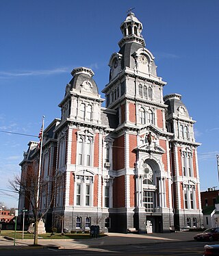
Van Wert County is a county located in the U.S. state of Ohio. As of the 2020 census, the population was 28,931. Its county seat is Van Wert. The county was created on February 12, 1820, and later organized on March 18, 1837. It is named for Isaac Van Wart, one of the captors of John André in the American Revolutionary War.

<span class="mw-page-title-main">Preble County, Ohio</span> County in Ohio, United States

Preble County is a county located in the U.S. state of Ohio. As of the 2020 census, the population was 40,999, down 3.0% from the 2010 census population of 42,270. Its county seat is Eaton. The county was formed on February 15, 1808, from portions of Butler and Montgomery Counties. It is named for Edward Preble, a naval officer who fought in the American Revolutionary War and against the Barbary Pirates.

<span class="mw-page-title-main">Darke County, Ohio</span> County in Ohio, United States

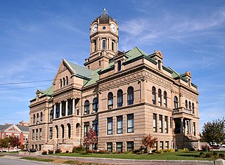
Darke County is a county in the U.S. state of Ohio. As of the 2020 census, the population was 51,881. Its county seat and largest city is Greenville. The county was created in 1809 and later organized in 1817. It is named for William Darke, an officer in the American Revolutionary War. Darke County comprises the Greenville, OH Micropolitan Statistical Area, which is also included in the Dayton-Springfield-Sidney, OH Combined Statistical Area.

<span class="mw-page-title-main">Auglaize County, Ohio</span> County in Ohio, United States

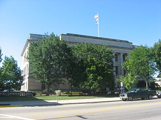
Auglaize County is a county in Northwestern Ohio, United States of America. As of the 2020 census, the population was 46,442. Its county seat and largest city is Wapakoneta.

<span class="mw-page-title-main">Kell, Illinois</span> Village in Illinois, United States

Kell is a village in Marion County, Illinois, United States. The population was 173 at the 2020 census, down from 219 in 2010.

<span class="mw-page-title-main">Joy, Illinois</span> Village in Illinois, United States

Joy is a village in Mercer County, Illinois, United States. The population was 372 as of the 2020 census.

<span class="mw-page-title-main">Seaton, Illinois</span> Village in Illinois, United States

Seaton is a village in Mercer County, Illinois, United States. The population was 214 at the 2020 census.

<span class="mw-page-title-main">Alamo, Indiana</span> Town in Indiana, United States

Alamo is a town in Ripley Township, Montgomery County, in the U.S. state of Indiana. The population was 66 at the 2020 census, unchanged from 2010.

<span class="mw-page-title-main">Arcanum, Ohio</span> Village in Ohio, United States

Arcanum is a village in Darke County, Ohio, United States. The population was 2,457 at the 2020 census.

<span class="mw-page-title-main">Gordon, Ohio</span> Village in Ohio, United States

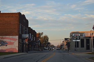
Gordon is a village in Darke County, Ohio, United States. The population was 245 at the 2020 census.

<span class="mw-page-title-main">Greenville, Ohio</span> City in Ohio, United States

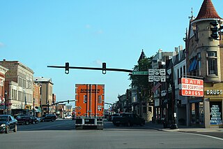
Greenville is a city in and the county seat of Darke County, Ohio, United States. It is located near Ohio's western edge, about 33 miles (53 km) northwest of Dayton. The population was 12,786 at the 2020 census.

<span class="mw-page-title-main">Ithaca, Ohio</span> Village in Ohio, United States

Ithaca is a village in Darke County, Ohio, United States. The population was 81 at the 2020 census.

<span class="mw-page-title-main">New Weston, Ohio</span> Village in Ohio, United States

New Weston is a village in Darke County, Ohio, United States. The population was 124 at the 2020 census.

<span class="mw-page-title-main">Palestine, Ohio</span> Village in Ohio, United States

Palestine is a village in Darke County, Ohio, United States. The population was 180 at the 2020 census.

<span class="mw-page-title-main">Pitsburg, Ohio</span> Village in Ohio, United States

Pitsburg is a village in Monroe Township, Darke County, Ohio, United States. The population was 381 at the 2020 census.

<span class="mw-page-title-main">Rossburg, Ohio</span> Village in Ohio, United States

Rossburg is a village in Darke County, Ohio, United States. The population was 159 at the 2020 census.

<span class="mw-page-title-main">Celina, Ohio</span> City in Ohio, United States

Celina is a city in and the county seat of Mercer County, Ohio, United States about 58 miles (93 km) northwest of Dayton. The population was 10,935 at the 2020 census. Celina is situated on the northwestern shores of Grand Lake St. Marys.

<span class="mw-page-title-main">Fairfield Township, Crawford County, Pennsylvania</span> Township in Pennsylvania, United States

Fairfield Township is a township in Crawford County, Pennsylvania, United States. The population was 1,011 at the 2020 census, down from the 2010 census.

<span class="mw-page-title-main">Bradford, Ohio</span> Village in Ohio, United States

Bradford is a village in Darke and Miami counties in the U.S. state of Ohio. The population was 1,796 at the 2020 census.

<span class="mw-page-title-main">Burkettsville, Ohio</span> Village in Ohio, United States

Burkettsville is a village in Darke and Mercer counties in the U.S. state of Ohio. The population was 272 at the 2020 census.

References

  1. 1 2 2020 census
  2. "Find a County". National Association of Counties. Archived from the original on May 31, 2011. Retrieved June 7, 2011.
  3. "Ohio: Individual County Chronologies". Ohio Atlas of Historical County Boundaries. The Newberry Library. 2007. Archived from the original on April 6, 2016. Retrieved February 14, 2015.
  4. "Mercer County data". Ohio State University Extension Data Center. Retrieved April 28, 2007.[ dead link ]
  5. "2010 Census Gazetteer Files". United States Census Bureau. August 22, 2012. Archived from the original on May 4, 2014. Retrieved February 9, 2015.
  6. "State may be ready to allow lake water out". The Daily Standard. Retrieved May 2, 2018.
  7. "Mercer County Commissioners". Mercer County Ohio Homepage. Retrieved May 8, 2015.
  8. "U.S. Decennial Census". United States Census Bureau. Retrieved February 9, 2015.
  9. "Historical Census Browser". University of Virginia Library. Retrieved February 9, 2015.
  10. Forstall, Richard L., ed. (March 27, 1995). "Population of Counties by Decennial Census: 1900 to 1990". United States Census Bureau. Retrieved February 9, 2015.
  11. "Census 2000 PHC-T-4. Ranking Tables for Counties: 1990 and 2000" (PDF). United States Census Bureau. April 2, 2001. Archived (PDF) from the original on March 27, 2010. Retrieved February 9, 2015.
  12. "U.S. Census website". United States Census Bureau . Retrieved January 31, 2008.
  13. 1 2 3 "DP-1 Profile of General Population and Housing Characteristics: 2010 Demographic Profile Data". United States Census Bureau. Archived from the original on February 13, 2020. Retrieved December 27, 2015.
  14. "Population, Housing Units, Area, and Density: 2010 – County". United States Census Bureau. Archived from the original on February 13, 2020. Retrieved December 27, 2015.
  15. "DP02 SELECTED SOCIAL CHARACTERISTICS IN THE UNITED STATES – 2006–2010 American Community Survey 5-Year Estimates". United States Census Bureau. Archived from the original on February 13, 2020. Retrieved December 27, 2015.
  16. "DP03 SELECTED ECONOMIC CHARACTERISTICS – 2006–2010 American Community Survey 5-Year Estimates". United States Census Bureau. Archived from the original on February 13, 2020. Retrieved December 27, 2015.
  17. Leip, David. "Dave Leip's Atlas of U.S. Presidential Elections". uselectionatlas.org. Retrieved May 2, 2018.
  18. Reinstein, Mara (April 3, 2020). "Tales From the Loop Brings Simon Stalenhag's Futuristic Artwork to Life". Architectural Digest . Retrieved April 3, 2020.

40°32′N84°38′W / 40.54°N 84.63°W / 40.54; -84.63