Morrow County, Ohio

Last updated

Morrow County
Mount-gilead-ohio-courthouse.jpg
Flag of Morrow County, Ohio.png
Seal of Morrow County Ohio.svg
Map of Ohio highlighting Morrow County.svg
Location within the U.S. state of Ohio
Ohio in United States.svg
Ohio's location within the U.S.
Coordinates: 40°32′N82°48′W / 40.53°N 82.8°W / 40.53; -82.8
CountryFlag of the United States.svg United States
StateFlag of Ohio.svg  Ohio
FoundedMarch 1, 1848 [1]
Named for Jeremiah Morrow
Seat Mount Gilead
Largest villageMount Gilead
Area
  Total407 sq mi (1,050 km2)
  Land406 sq mi (1,050 km2)
  Water1.1 sq mi (3 km2)  0.3%
Population
 (2020)
  Total34,950
  Density86/sq mi (33/km2)
Time zone UTC−5 (Eastern)
  Summer (DST) UTC−4 (EDT)
Congressional district 4th
Website www.morrowcountyohio.gov
Old Morrow County Jail Mount-gilead-ohio-jail.jpg
Old Morrow County Jail

Morrow County is a county located in the central portion of the U.S. state of Ohio. As of the 2020 census, the population was 34,950. [2] Its county seat is Mount Gilead. [3] The county was organized in 1848 from parts of four neighboring counties and named for Jeremiah Morrow who was the Governor of Ohio from 1822 to 1826. Shawnee people used the area for hunting purposes before white settlers arrived in the early 19th century.

Contents

Morrow County is included in the Columbus, OH Metropolitan Statistical Area.

In 2010, the center of population of Ohio was located in Morrow County, near the village of Marengo. [4]

Morrow County's historic World War I Victory Shaft, unique in the United States, is located in the center of downtown Mount Gilead. Other areas interesting to the tourist include: Mount Gilead State Park; Amish farms and businesses near Johnsville and Chesterville; the Mid-Ohio Sports Car Course near Steam Corners; the rolling Allegheny foothills of eastern Morrow County; the site of the birthplace of President Warren G. Harding near Blooming Grove; the site of the former Ohio Central College in Iberia; the early 19th-century architecture of buildings in Chesterville, Ohio; the Revolutionary War Soldiers' Memorial in Mount Gilead; the Civil War monument in Cardington; and the mid-19th-century architecture of the Morrow County Courthouse and Old Jail in Mount Gilead.

Geography

According to the U.S. Census Bureau, the county has a total area of 407 square miles (1,050 km2), of which 406 square miles (1,050 km2) is land and 1.1 square miles (2.8 km2) (0.3%) is water. [5] Morrow County is considered to be a part of "Mid Ohio."

Adjacent counties

Water features

Ossing Run
Ossing Run.JPG
Ossing Run is located in Cardington, Ohio
Location
Country United States
Physical characteristics
Source 
  coordinates 40°31′23″N82°57′05″W / 40.52306°N 82.95139°W / 40.52306; -82.95139 (Ossing Run source)
  elevation968 ft (295 m)
Mouth  
  coordinates
40°29′57″N82°56′40″W / 40.49917°N 82.94444°W / 40.49917; -82.94444 (Ossing Run mouth)
Length1.6 mi (2.6 km)

Ossing Run is a tributary of Shaw Creek that flows through Morrow County, Ohio. [6] Shaw Creek flows into Whetstone Creek which is located adjacent to Cardington, Ohio. The United States Geological Survey’s Geographic Names Information System (GNIS) classifies Ossing Run as a stream with an identification number of 2761345. The feature name was entered into the GNIS system in April 2014. [7]

Demographics

Historical population
CensusPop.Note
1850 20,280
1860 20,4450.8%
1870 18,583−9.1%
1880 19,0722.6%
1890 18,120−5.0%
1900 17,879−1.3%
1910 16,815−6.0%
1920 15,570−7.4%
1930 14,489−6.9%
1940 15,6468.0%
1950 17,1689.7%
1960 19,40513.0%
1970 21,34810.0%
1980 26,48024.0%
1990 27,7494.8%
2000 31,62814.0%
2010 34,82710.1%
2020 34,9500.4%
U.S. Decennial Census [8]
1790-1960 [9] 1900-1990 [10]
1990-2000 [11] 2020 [2]

2000 census

As of the census [12] of 2000, there were 31,628 people, 11,499 households, and 8,854 families living in the county. The population density was 78 inhabitants per square mile (30/km2). There were 12,132 housing units at an average density of 30 units per square mile (12/km2). The racial makeup of the county was 98.37% White, 0.27% Black or African American, 0.30% Native American, 0.15% Asian, 0.18% from other races, and 0.74% from two or more races. 0.58% of the population were Hispanic or Latino of any race.

There were 11,499 households, out of which 35.60% had children under the age of 18 living with them, 64.60% were married couples living together, 8.10% had a female householder with no husband present, and 23.00% were non-families. 19.00% of all households were made up of individuals, and 7.90% had someone living alone who was 65 years of age or older. The average household size was 2.72 and the average family size was 3.09.

In the county, the population was spread out, with 27.30% under the age of 18, 7.60% from 18 to 24, 29.30% from 25 to 44, 24.30% from 45 to 64, and 11.50% who were 65 years of age or older. The median age was 36 years. For every 100 females there were 99.40 males. For every 100 females age 18 and over, there were 98.00 males.

The median income for a household in the county was $40,882, and the median income for a family was $45,747. Males had a median income of $33,129 versus $22,454 for females. The per capita income for the county was $17,830. About 6.60% of families and 9.00% of the population were below the poverty line, including 12.40% of those under age 18 and 7.10% of those age 65 or over.

2010 census

As of the 2010 United States Census, there were 34,827 people, 12,855 households, and 9,578 families living in the county. [13] The population density was 85.8 inhabitants per square mile (33.1/km2). There were 14,155 housing units at an average density of 34.9 units per square mile (13.5 units/km2). [14] The racial makeup of the county was 97.7% white, 0.3% Asian, 0.1% American Indian, 0.2% from other races, and 1.3% from two or more races. Those of Hispanic or Latino origin made up 1.1% of the population. [13] In terms of ancestry, 30.8% were German, 16.1% were American, 14.4% were Irish, and 13.3% were English. [15]

Of the 12,855 households, 35.1% had children under the age of 18 living with them, 59.5% were married couples living together, 9.5% had a female householder with no husband present, 25.5% were non-families, and 20.7% of all households were made up of individuals. The average household size was 2.68 and the average family size was 3.08. The median age was 39.5 years. [13]

The median income for a household in the county was $49,891 and the median income for a family was $55,980. Males had a median income of $41,096 versus $32,911 for females. The per capita income for the county was $20,795. About 7.5% of families and 10.8% of the population were below the poverty line, including 13.9% of those under age 18 and 9.5% of those age 65 or over. [16]

Politics

Morrow County is a Republican stronghold county. The last time it voted for a Democratic candidate was in 1964 when it voted for Lyndon B. Johnson.

United States presidential election results for Morrow County, Ohio [17]
Year Republican Democratic Third party
No.%No.%No.%
2020 14,07776.22%4,04821.92%3431.86%
2016 11,94871.60%3,76122.54%9795.87%
2012 9,86560.83%5,93336.59%4192.58%
2008 10,06760.36%6,17737.03%4352.61%
2004 10,47464.15%5,77535.37%790.48%
2000 7,84261.08%4,52935.28%4683.65%
1996 5,65546.07%4,62737.69%1,99316.24%
1992 5,20840.72%3,90730.54%3,67628.74%
1988 7,13066.26%3,51532.67%1151.07%
1984 8,11673.50%2,83925.71%870.79%
1980 6,17961.96%3,23932.48%5545.56%
1976 5,81453.28%4,87044.63%2282.09%
1972 6,88670.56%2,52725.89%3463.55%
1968 4,89855.58%2,40527.29%1,50917.12%
1964 4,19447.84%4,57252.16%00.00%
1960 6,35769.91%2,73630.09%00.00%
1956 5,88571.56%2,33928.44%00.00%
1952 6,10671.96%2,37928.04%00.00%
1948 4,32762.21%2,61637.61%120.17%
1944 5,43969.78%2,35630.22%00.00%
1940 5,45762.93%3,21537.07%00.00%
1936 4,08649.52%3,94747.83%2192.65%
1932 3,81148.82%3,84949.31%1461.87%
1928 4,80171.67%1,81827.14%801.19%
1924 3,79057.39%2,37936.02%4356.59%
1920 4,48460.78%2,85838.74%360.49%
1916 2,06245.41%2,34551.64%1342.95%
1912 1,24027.65%1,88041.92%1,36530.43%
1908 2,50051.06%2,23945.73%1573.21%
1904 2,56355.18%1,82739.33%2555.49%
1900 2,60551.58%2,27845.11%1673.31%
1896 2,50648.79%2,51749.01%1132.20%
1892 2,29749.07%1,95841.83%4269.10%
1888 2,51451.02%2,06841.97%3457.00%
1884 2,61252.39%2,16043.32%2144.29%
1880 2,58152.92%2,14343.94%1533.14%
1876 2,45053.45%2,04644.63%881.92%
1872 2,19755.85%1,68942.93%481.22%
1868 2,46958.24%1,77041.76%00.00%
1864 2,36658.83%1,65641.17%00.00%
1860 2,26053.18%1,92845.36%621.46%
1856 2,03153.46%1,66743.88%1012.66%

Government

Communities

Cities

Villages

Townships

Census-designated places

Unincorporated communities

Notable residents

See also

Related Research Articles

<span class="mw-page-title-main">Wyandot County, Ohio</span> County in Ohio, United States

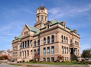
Wyandot County is a county located in the northwestern part of the U.S. state of Ohio. As of the 2020 census, the population was 21,900. Its county seat is Upper Sandusky. It was named for the Wyandot Indians, who lived here before and after European encounter. Their autonym is variously translated from their language as "around the plains" and "dwellers on the peninsula". The county was organized by the state legislature from parts of Crawford, Marion, Hardin and Hancock counties on February 3, 1845.

<span class="mw-page-title-main">Williams County, Ohio</span> County in Ohio, United States

Williams County is a county located in the U.S. state of Ohio. As of the 2020 census, the population was 37,102. Its county seat is Bryan. The county was created in 1820 and later organized in 1824. It is named for David Williams, one of the captors of John André in the American Revolutionary War.

<span class="mw-page-title-main">Noble County, Ohio</span> County in Ohio, United States

Noble County is a county located in the U.S. state of Ohio. As of the 2020 census, the population was 14,115, making it the fourth-least populous county in Ohio. Its county seat is Caldwell. The county is named for Rep. Warren P. Noble of the Ohio House of Representatives, who was an early settler there.

<span class="mw-page-title-main">Marion County, Ohio</span> County in Ohio, United States

Marion County is a county located in the U.S. state of Ohio. As of the 2020 census, the population was 65,359. Its county seat is Marion. The county was created in 1820 and later organized in 1824. It is named for General Francis "The Swamp Fox" Marion, a South Carolinian officer in the Revolutionary War.

<span class="mw-page-title-main">Hancock County, Ohio</span> County in Ohio, United States

Hancock County is a county located in the U.S. state of Ohio. As of the 2020 census, the population was 74,920. Its county seat and largest city is Findlay. The county was created in 1820 and later organized in 1828. It was named for John Hancock, the first signer of the Declaration of Independence.

<span class="mw-page-title-main">Crawford County, Ohio</span> County in Ohio, United States

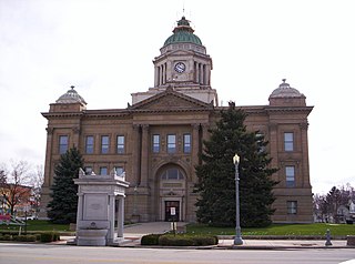
Crawford County is a county located in the north central portion of the U.S. state of Ohio. As of the 2020 census, the population was 42,025. Its county seat and largest city is Bucyrus. The county was created in 1820 and later organized in 1836. It was named for Colonel William Crawford, a soldier during the American Revolution. Crawford County comprises the Bucyrus, OH Micropolitan Statistical Area, which is also included in the Mansfield-Ashland-Bucyrus, OH Combined Statistical Area.

<span class="mw-page-title-main">Auglaize County, Ohio</span> County in Ohio, United States

Auglaize County is a county in Northwestern Ohio, United States of America. As of the 2020 census, the population was 46,442. Its county seat and largest city is Wapakoneta.

<span class="mw-page-title-main">Chesterville, Maine</span> Town in Maine, United States

Chesterville is a town in Franklin County, Maine, United States. The population was 1,328 at the 2020 census.

<span class="mw-page-title-main">Gilead Township, Michigan</span> Civil township in Michigan, United States

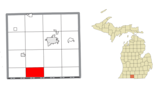
Gilead Township is a civil township of Branch County in the U.S. state of Michigan. As of the 2020 census, the township population was 656.

<span class="mw-page-title-main">Gilead, Nebraska</span> Village in Thayer County, Nebraska, United States

Gilead is a village in Thayer County, Nebraska, United States. The population was 32 at the 2020 census.

<span class="mw-page-title-main">Mount Cory, Ohio</span> Village in Ohio, United States

Mount Cory is a village in Hancock County, Ohio, United States. The population was 225 at the 2020 census.

<span class="mw-page-title-main">Cardington, Ohio</span> Village in Ohio, United States

Cardington is a village in Morrow County, Ohio, United States. The population was 2,051 at the 2020 census. Mount Gilead, Ohio, the county seat, is located northeast of Cardington on U.S. Route 42.

<span class="mw-page-title-main">Chesterville, Ohio</span> Village in Ohio, United States

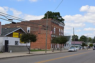
Chesterville is a village in Morrow County, Ohio, United States, along the Kokosing River. The population was 191 at the 2020 census. Chesterville is southeast of Mount Gilead, the county seat.

<span class="mw-page-title-main">Edison, Ohio</span> Village in Ohio, United States

Edison is a village in Morrow County, Ohio, United States. The population was 422 at the 2020 census. Edison is adjacent to and west of Mount Gilead, Ohio, the county seat.

<span class="mw-page-title-main">Fulton, Ohio</span> Village in Ohio, United States

Fulton is a village in Morrow County, Ohio, United States. The population was 250 at the 2020 census. Fulton is south of Mount Gilead, the county seat.

<span class="mw-page-title-main">Marengo, Ohio</span> Village in Ohio, United States

Marengo is a village in Morrow County, Ohio, United States. The population was 283 at the 2020 census. Marengo is south of Mount Gilead, the county seat.

<span class="mw-page-title-main">Mount Gilead, Ohio</span> Village in Ohio, United States

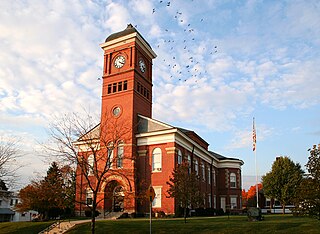
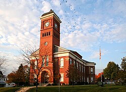
Mount Gilead is a village and the county seat of Morrow County, Ohio, United States. It is located 41 miles (66 km) northeast of Columbus. The population was 3,503 at the 2020 census. It is the center of population of Ohio. The village was established in 1832, eight years after white settlers arrived in the region. Before their arrival, the forest was a hunting area for the Shawnee tribe.

<span class="mw-page-title-main">Sparta, Ohio</span> Village in Ohio, United States

Sparta is a village in Morrow County, Ohio, United States. The population was 121 at the 2020 census. Sparta is southeast of Mount Gilead, the county seat.

<span class="mw-page-title-main">Morrow, Ohio</span> Village in Ohio, United States

Morrow is a village in Salem Township, Warren County, Ohio, United States. The population was 2,049 at the 2020 census.

<span class="mw-page-title-main">Grand Rapids, Ohio</span> Village in Ohio, USA

Grand Rapids is a village in Grand Rapids Township, Wood County, Ohio, United States, along the Maumee River. The population was 925 at the 2020 census. Grand Rapids is served by a branch of the Weston Public Library.

References

  1. "Ohio County Profiles: Morrow County" (PDF). Ohio Department of Development. Archived from the original (PDF) on June 21, 2007. Retrieved April 28, 2007.
  2. 1 2 2020 census
  3. "Find a County". National Association of Counties. Retrieved June 7, 2011.
  4. "Centers of Population by State: 2010". United States Census Bureau. Retrieved April 18, 2014.
  5. "2010 Census Gazetteer Files". United States Census Bureau. August 22, 2012. Archived from the original on May 4, 2014. Retrieved February 9, 2015.
  6. "14-R-046" (PDF). Commissioners' Journal. January 22, 2014. Archived from the original (PDF) on April 2, 2015. Retrieved February 10, 2015.
  7. "GNIS". Geographic Names Information System. United States Geological Survey. Retrieved December 9, 2014.
  8. "U.S. Decennial Census". United States Census Bureau. Retrieved February 9, 2015.
  9. "Historical Census Browser". University of Virginia Library. Retrieved February 9, 2015.
  10. Forstall, Richard L., ed. (March 27, 1995). "Population of Counties by Decennial Census: 1900 to 1990". United States Census Bureau. Retrieved February 9, 2015.
  11. "Census 2000 PHC-T-4. Ranking Tables for Counties: 1990 and 2000" (PDF). United States Census Bureau. April 2, 2001. Archived (PDF) from the original on March 27, 2010. Retrieved February 9, 2015.
  12. "U.S. Census website". United States Census Bureau . Retrieved January 31, 2008.
  13. 1 2 3 "DP-1 Profile of General Population and Housing Characteristics: 2010 Demographic Profile Data". United States Census Bureau. Archived from the original on February 13, 2020. Retrieved December 27, 2015.
  14. "Population, Housing Units, Area, and Density: 2010 - County". United States Census Bureau. Archived from the original on February 13, 2020. Retrieved December 27, 2015.
  15. "DP02 SELECTED SOCIAL CHARACTERISTICS IN THE UNITED STATES – 2006-2010 American Community Survey 5-Year Estimates". United States Census Bureau. Archived from the original on February 13, 2020. Retrieved December 27, 2015.
  16. "DP03 SELECTED ECONOMIC CHARACTERISTICS – 2006-2010 American Community Survey 5-Year Estimates". United States Census Bureau. Archived from the original on February 13, 2020. Retrieved December 27, 2015.
  17. Leip, David. "Dave Leip's Atlas of U.S. Presidential Elections". uselectionatlas.org. Retrieved May 2, 2018.

40°32′N82°48′W / 40.53°N 82.80°W / 40.53; -82.80