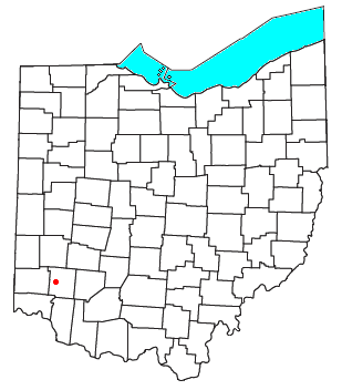
Morrow County is a county located in the central portion of the U.S. state of Ohio. As of the 2020 census, the population was 34,950. Its county seat is Mount Gilead. The county was organized in 1848 from parts of four neighboring counties and named for Jeremiah Morrow who was the Governor of Ohio from 1822 to 1826. Shawnee people used the area for hunting purposes before white settlers arrived in the early 19th century.

Marion is a city in and the county seat of Marion County, Ohio, United States. It is located in north-central Ohio, approximately 50 miles (80 km) north of Columbus. The population was 35,999 at the 2020 census, down slightly from 36,837 at the 2010 census. It is the largest city in Marion County and the principal city of the Marion micropolitan area. It is also part of the larger Columbus–Marion–Zanesville, OH Combined Statistical Area.
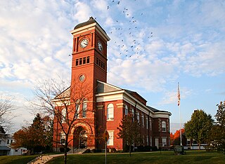
Mount Gilead is a village and the county seat of Morrow County, Ohio, United States. It is located 41 miles (66 km) northeast of Columbus. The population was 3,503 at the 2020 census. It is the center of population of Ohio. The village was established in 1832, eight years after white settlers arrived in the region. Before their arrival, the forest was a hunting area for the Shawnee tribe.

Franklin is a city in Warren County, Ohio, United States, along the Great Miami River. The population was 11,690 at the 2020 census. The city lies about 15 miles (24 km) southwest of Dayton and 33.5 miles (53.9 km) northeast of Cincinnati. Ohio State Routes 73, 123 and 741 pass through Franklin, while Interstate 75 passes on the east side of the city.
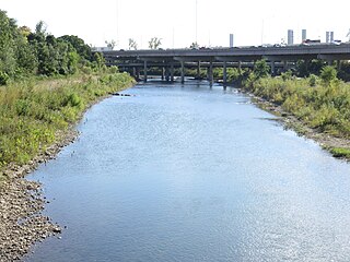
The Olentangy River is a 97-mile-long (156 km) tributary of the Scioto River in Ohio, United States.

Point Pleasant is a small unincorporated community in southern Monroe Township, Clermont County, Ohio, United States. It is located on the Ohio River, around 25 miles (40 km) southeast of Cincinnati. U.S. Route 52 passes through Point Pleasant, where it intersects State Route 232.
Hillcrest is an unincorporated place in central Warren County, Ohio, United States on U.S. Route 42 about halfway between Mason, 4 miles to the southwest, and Lebanon, 3 mi (5 km) to the northeast. The community straddles the township line between Turtlecreek and Union Townships. The former Cincinnati, Lebanon and Northern Railway runs just east of the community and once had a stop here called "Turtlecreek". It is in the Lebanon City School District and is served by the Lebanon telephone exchange and post office.

William Estabrook Chancellor was an American academic and writer. An opponent of the 1920 Republican presidential candidate, Warren G. Harding, Chancellor gained notoriety when he allegedly wrote a study of Harding's ancestry just prior to the election, asserting that Harding had an African-American ancestor. Chancellor denied authorship, and it has never been proved. Two years later, a biography of Harding was published under Chancellor's name, but Chancellor denied authorship of that as well.

Iberia is a census-designated place in western Washington Township, Morrow County, Ohio, United States. The community is served by the Northmor Local School District which formerly operated Iberia Elementary School in the community. Iberia is near to Galion, and Martel. The ZIP code assigned to Iberia by the United States Postal Service is 43325. The current population of Iberia is less than 200 as of the 2000 census. Iberia is northwest of Mount Gilead, the county seat.
Ohio Central College, initially known as Iberia College, was a college located in Iberia, Ohio in northwestern Morrow County, Ohio during the second half of the 19th century. Open to both genders and all races, the college was founded by the Free Presbyterian Church and led by the Rev. George Gordon, a strong abolitionist. It counts among its alumni Warren G. Harding, a native of Morrow County and the 29th President of the United States.

North Bloomfield Township is one of the sixteen townships of Morrow County, Ohio, United States. The 2010 census found 1,863 people in the township.

East Fultonham is a census-designated place in central Newton Township, Muskingum County, Ohio, United States. It has a post office with the ZIP code 43735. It is located along U.S. Route 22 a short distance east of the village of Fultonham.
Wyandot is an unincorporated community in Wyandot County, in the U.S. state of Ohio.
Bloomfield is an unincorporated community in Morrow County, in the U.S. state of Ohio.
Fargo is an unincorporated community in Morrow County, in the U.S. state of Ohio.

Florida Grove is a ghost town in Morrow County, in the U.S. state of Ohio.

North Woodbury is an unincorporated community in Morrow County, in the U.S. state of Ohio.
West Liberty is an unincorporated community in Morrow County, in the U.S. state of Ohio.
West Point is an unincorporated community in Morrow County, in the U.S. state of Ohio.
Williamsport is an unincorporated community in Morrow County, in the U.S. state of Ohio.

