Morrow, Ohio

Last updated

Morrow, Ohio
Morrow village hall from across the Todd Fork.jpg
Village Hall
Flag of Morrow, Ohio.png
OHMap-doton-Morrow.png
Location of Morrow, Ohio
Map of Warren County Ohio Highlighting Morrow Village.png
Location of Morrow in Warren County
Coordinates: 39°20′58″N84°07′37″W / 39.34944°N 84.12694°W / 39.34944; -84.12694
Country United States
State Ohio
County Warren
Area
[1]
  Total2.11 sq mi (5.45 km2)
  Land2.04 sq mi (5.28 km2)
  Water0.07 sq mi (0.18 km2)
Elevation
[2]
643 ft (196 m)
Population
 (2020)
  Total2,049
  Density1,005.89/sq mi (388.36/km2)
Time zone UTC−5 (Eastern (EST))
  Summer (DST) UTC−4 (EDT)
ZIP Code
45152
Area code 513
FIPS code 39-52374 [3]
GNIS feature ID2399400 [2]
Website www.vil.morrow.oh.us/

Morrow is a village in Salem Township, Warren County, Ohio, United States. The population was 2,049 at the 2020 census.

Contents

History

Morrow was platted in 1845, when the railroad was extended to that point. [4] The village is named for Jeremiah Morrow, 9th Governor of Ohio. [5] A post office has been in operation at Morrow since 1845. [6]

Geography

According to the United States Census Bureau, the village has a total area of 1.97 square miles (5.10 km2), of which 1.93 square miles (5.00 km2) is land and 0.04 square miles (0.10 km2) is water. [7]

Demographics

Historical population
CensusPop.Note
1850 459
1860 72056.9%
1870 708−1.7%
1880 94633.6%
1890 842−11.0%
1900 8693.2%
1910 832−4.3%
1920 803−3.5%
1930 738−8.1%
1940 84013.8%
1950 1,13735.4%
1960 1,47729.9%
1970 1,4860.6%
1980 1,254−15.6%
1990 1,206−3.8%
2000 1,2866.6%
2010 1,188−7.6%
2020 2,04972.5%
U.S. Decennial Census [8]

2010 census

As of the census [9] of 2010, there were 1,188 people, 455 households, and 298 families living in the village. The population density was 615.5 inhabitants per square mile (237.6/km2). There were 522 housing units at an average density of 270.5 per square mile (104.4/km2). The racial makeup of the village was 96.5% White, 0.4% African American, 0.2% Native American, 0.3% Asian, 0.6% from other races, and 2.0% from two or more races. Hispanic or Latino of any race were 2.0% of the population.

There were 455 households, of which 36.3% had children under the age of 18 living with them, 45.5% were married couples living together, 13.4% had a female householder with no husband present, 6.6% had a male householder with no wife present, and 34.5% were non-families. Of all households 29.0% were made up of individuals, and 17.6% had someone living alone who was 65 years of age or older. The average household size was 2.53 and the average family size was 3.07.

The median age in the village was 39 years. 24.8% of residents were under the age of 18; 6.7% were between the ages of 18 and 24; 26.7% were from 25 to 44; 26% were from 45 to 64; and 15.8% were 65 years of age or older. The gender makeup of the village was 48.2% male and 51.8% female.

2000 census

As of the census [3] of 2000, there were 1,286 people, 462 households, and 298 families living in the village. The population density was 760.7 inhabitants per square mile (293.7/km2). There were 498 housing units at an average density of 294.6 per square mile (113.7/km2). The racial makeup of the village was 97.82% White, 0.70% African American, 0.86% Native American, 0.08% Asian, 0.16% from other races, and 0.39% from two or more races. Hispanic or Latino of any race were 2.18% of the population.

There were 462 households, out of which 34.0% had children under the age of 18 living with them, 47.4% were married couples living together, 14.1% had a female householder with no husband present, and 35.3% were non-families. Of all households 29.0% were made up of individuals, and 14.5% had someone living alone who was 65 years of age or older. The average household size was 2.58 and the average family size was 3.19.

In the village, the population was spread out, with 25.6% under the age of 18, 6.6% from 18 to 24, 30.6% from 25 to 44, 21.4% from 45 to 64, and 15.9% who were 65 years of age or older. The median age was 37 years. For every 100 females there were 85.8 males. For every 100 females age 18 and over, there were 83.0 males.

The median income for a household in the village was $32,566, and the median income for a family was $44,750. Males had a median income of $31,827 versus $24,444 for females. The per capita income for the village was $15,416. About 5.2% of families and 15.5% of the population were below the poverty line, including 10.1% of those under age 18 and 11.1% of those age 65 or over.

Education

The village is in the Little Miami Local School District.

The Salem Township Public Library is a lending library located within the village limits. [10]

Government and infrastructure

The Morrow Post Office of the United States Postal Service is located at 531 West Pike Street. [11]

The village has a 1% income tax. [12]

Music

Notable people

Related Research Articles

<span class="mw-page-title-main">Morrow County, Ohio</span> County in Ohio, United States

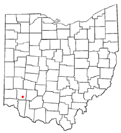
Morrow County is a county located in the central portion of the U.S. state of Ohio. As of the 2020 census, the population was 34,950. Its county seat is Mount Gilead. The county was organized in 1848 from parts of four neighboring counties and named for Jeremiah Morrow who was the Governor of Ohio from 1822 to 1826. Shawnee people used the area for hunting purposes before white settlers arrived in the early 19th century. Morrow County is included in the Columbus, OH Metropolitan Statistical Area. In 2010, the center of population of Ohio was located in Morrow County, near the village of Marengo.

<span class="mw-page-title-main">Fort Shawnee, Ohio</span> CDP in Ohio, United States

Fort Shawnee is census-designated place (CDP) in Allen County, Ohio, United States. The population was 6,263 at the 2020 census. It is included in the Lima, Ohio Metropolitan Statistical Area. Fort Shawnee is adjacent to the city of Lima and the village of Cridersville in Auglaize County. In 2012, village residents voted to disincorporate the village. According to the United States Census Bureau, the village had a total area of 7.25 square miles (18.78 km2), of which 7.21 square miles (18.67 km2) is land and 0.04 square miles (0.10 km2) is water.

<span class="mw-page-title-main">Hamersville, Ohio</span> Village in Ohio, United States

Hamersville is a village in Clark Township, Brown County, Ohio, United States. The population was 485 at the 2020 census.

<span class="mw-page-title-main">Lockbourne, Ohio</span> Village in Ohio, United States

Lockbourne is a village in Franklin County and Pickaway County, Ohio, United States. The population was 236 at the 2020 census. Lockbourne is located near Rickenbacker International Airport, and had initially provided its original name of Lockbourne Air Force Base.

<span class="mw-page-title-main">Woodlawn, Ohio</span> Village in Ohio, United States

Woodlawn is a village in Hamilton County, Ohio, United States. The population was 3,916 at the 2020 census.

<span class="mw-page-title-main">Martinsburg, Ohio</span> Village in Ohio, United States

Martinsburg is a village in Knox County, Ohio, United States. The population was 222 at the 2020 census.

<span class="mw-page-title-main">Hanover, Ohio</span> Village in Ohio, United States

Hanover is a village in Licking County, Ohio, United States. The population was 1,270 at the 2020 census. The village lies along Ohio State Route 16.

<span class="mw-page-title-main">Hebron, Ohio</span> Village in Ohio, USA

Hebron is a village in Licking County, Ohio, United States. The population was 2,326 at the 2020 census.

<span class="mw-page-title-main">South Solon, Ohio</span> Village in Ohio, United States

South Solon is a village in Madison County, Ohio, United States. The population was 329 at the 2020 census. Despite their similar names, South Solon is not adjacent to the city of Solon, Ohio, a suburb of Cleveland in Cuyahoga County. The two towns are approximately 170 miles (270 km) apart.

<span class="mw-page-title-main">Beloit, Ohio</span> Village in Ohio, United States

Beloit is a village in southwestern Mahoning County, Ohio, United States. The population was 903 at the 2020 census. It is part of the Youngstown–Warren metropolitan area.

<span class="mw-page-title-main">Cardington, Ohio</span> Village in Ohio, United States

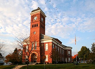
Cardington is a village in Morrow County, Ohio, United States. The population was 2,051 at the 2020 census. Mount Gilead, Ohio, the county seat, is located northeast of Cardington on U.S. Route 42.

<span class="mw-page-title-main">Chesterville, Ohio</span> Village in Ohio, United States

Chesterville is a village in Morrow County, Ohio, United States, along the Kokosing River. The population was 191 at the 2020 census. Chesterville is southeast of Mount Gilead, the county seat.

<span class="mw-page-title-main">Edison, Ohio</span> Village in Ohio, United States

Edison is a village in Morrow County, Ohio, United States. The population was 422 at the 2020 census. Edison is adjacent to and west of Mount Gilead, Ohio, the county seat.

<span class="mw-page-title-main">Fulton, Ohio</span> Village in Ohio, United States

Fulton is a village in Morrow County, Ohio, United States. The population was 250 at the 2020 census. Fulton is south of Mount Gilead, the county seat.

<span class="mw-page-title-main">Marengo, Ohio</span> Village in Ohio, United States

Marengo is a village in Morrow County, Ohio, United States. The population was 283 at the 2020 census. Marengo is south of Mount Gilead, the county seat.

<span class="mw-page-title-main">Sparta, Ohio</span> Village in Ohio, United States

Sparta is a village in Morrow County, Ohio, United States. The population was 121 at the 2020 census. Sparta is southeast of Mount Gilead, the county seat.

<span class="mw-page-title-main">Haviland, Ohio</span> Village in Ohio, United States

Haviland is a village in Paulding County, Ohio, United States. The population was 160 at the 2020 census.

<span class="mw-page-title-main">Port Jefferson, Ohio</span> Village in Ohio, United States

Port Jefferson is a village in Salem Township, Shelby County, Ohio, United States. The population was 308 at the 2020 census.

<span class="mw-page-title-main">Congress, Ohio</span> Village in Ohio, United States

Congress is a village in Wayne County, Ohio, United States. The population was 132 at the 2020 census.

<span class="mw-page-title-main">Verona, Ohio</span> Village in Ohio, United States

Verona is a village in Montgomery and Preble counties in the U.S. state of Ohio. The population was 403 at the 2020 census. It is part of the Dayton Metropolitan Statistical Area.

References

  1. "ArcGIS REST Services Directory". United States Census Bureau. Retrieved September 20, 2022.
  2. 1 2 U.S. Geological Survey Geographic Names Information System: Morrow, Ohio
  3. 1 2 "U.S. Census website". United States Census Bureau . Retrieved January 31, 2008.
  4. The History of Warren County, Ohio: Containing a History of the County ; Its Townships, Towns. W.H. Beers & Company. 1882. p. 668.
  5. Goodman, Rebecca (2005). This Day in Ohio History. Emmis Books. p. 304. ISBN   9781578601912 . Retrieved November 21, 2013.
  6. "Warren County". Jim Forte Postal History. Retrieved March 2, 2015.
  7. "US Gazetteer files 2010". United States Census Bureau. Archived from the original on January 25, 2012. Retrieved January 6, 2013.
  8. "Census of Population and Housing". Census.gov. Retrieved June 4, 2015.
  9. "U.S. Census website". United States Census Bureau . Retrieved January 6, 2013.
  10. "Homepage". Salem Township Public Library. Retrieved March 3, 2018.
  11. "Post Office Location - Morrow." United States Postal Service . Retrieved on February 12, 2009.
  12. "Morrow Tax Department". Village of Morrow. Retrieved February 22, 2019.
  13. "I want to go to Morrow". Library of Congress .