Socialville, Ohio

Last updated

Socialville is an unincorporated community in Warren County, in the U.S. state of Ohio. [1]

Warren County, Ohio U.S. county in Ohio

Warren County is a county in the U.S. state of Ohio. As of the 2010 census, the population was 212,693. Its county seat is Lebanon. The county was created on May 1, 1803 from Hamilton County; it is named for Dr. Joseph Warren, a hero of the Revolution who sent Paul Revere and the overlooked William Dawes on their famous rides and who died at the Battle of Bunker Hill.

U.S. state constituent political entity of the United States

In the United States, a state is a constituent political entity, of which there are currently 50. Bound together in a political union, each state holds governmental jurisdiction over a separate and defined geographic territory and shares its sovereignty with the federal government. Due to this shared sovereignty, Americans are citizens both of the federal republic and of the state in which they reside. State citizenship and residency are flexible, and no government approval is required to move between states, except for persons restricted by certain types of court orders.

Ohio U.S. state in the United States

Ohio is a Midwestern state in the Great Lakes region of the United States. Of the fifty states, it is the 34th largest by area, the seventh most populous, and the tenth most densely populated. The state's capital and largest city is Columbus. Ohio is bordered by Pennsylvania to the east, Michigan to the northwest, Lake Erie to the north, Indiana to the west, Kentucky on the south, and West Virginia on the southeast.

History

Socialville was originally called Mormontown, and under the latter name was built up by Mormons in the 1840s. [2] A post office called Socialville was established in 1878, and remained in operation until 1913. [3] By 1882, Socialville had a population of sixty. [4]

Mormons Religious group part of the Latter Day Saint movement

Mormons are a religious and cultural group related to Mormonism, the principal branch of the Latter Day Saint movement of Restorationist Christianity, initiated by Joseph Smith in upstate New York during the 1820s. After Smith's death in 1844, the Mormons followed Brigham Young to what would become the Utah Territory. Today, most Mormons are understood to be members of The Church of Jesus Christ of Latter-day Saints. Other Mormons may be independently religious, secular and non-practicing, or belong to another denomination. The center of Mormon cultural influence is in Utah, and North America has more Mormons than any other continent, though the majority of Mormons live outside the United States.

Related Research Articles

Hagemans Crossing, Ohio human settlement in Ohio, United States of America

Hagemans Crossing is an unincorporated community in Union Township, Warren County, Ohio, United States. Located in the western part of the township, it is located on the old Cincinnati and Xenia Pike, now U.S. Route 42, about halfway between Lebanon and Mason. It was at the crossing of the Middletown and Cincinnati Railroad and the Cincinnati, Lebanon and Northern Railway and was about two miles northwest of the M&C's eastern terminus at Middletown Junction.

Cozaddale, Ohio human settlement in Ohio, United States of America

Cozaddale is an unincorporated community in southeastern Hamilton Township, Warren County, Ohio, United States. It is about one mile south of Comargo, one mile southeast of Hickory Corner, and two miles west of Pleasant Plain, and three miles north of Goshen, Ohio.

Zoar, Warren County, Ohio human settlement in Ohio, United States of America

Zoar is an unincorporated community in northern Hamilton Township, Warren County, Ohio, United States. It is located on the 3C Highway about one mile east of Hopkinsville and three miles west of Morrow in Virginia Military District Military Survey 1546.

Murdoch, Ohio human settlement in United States of America

Murdoch is an unincorporated community in southern Hamilton Township, Warren County, Ohio, United States. It is located about two miles southeast of Maineville and two miles northwest of Cozaddale.

Dallasburg, Ohio human settlement in Ohio, United States of America

Dallasburg is an unincorporated community in southern Hamilton Township, Warren County, Ohio, United States. It is located in Virginia Military Reserve Military Survey 3790, about one mile west of Cozaddale and two miles southeast of Murdoch.

Dodds, Ohio human settlement in Ohio, United States of America

Dodds is an unincorporated community in eastern Clearcreek Township, Warren County, Ohio, United States, formerly on the Cincinnati, Lebanon and Northern Railway.

Level, Ohio human settlement in United States of America

Level is an unincorporated community in southern Harlan Township, Warren County, Ohio, United States, which in the 19th century was a station on the Marietta and Cincinnati Railroad and had its own post office, since closed. According to the U.S. Geographic Names Information System (GNIS), an alternate name for this community is Windsor.

Red Lion, Ohio human settlement in Ohio, United States of America

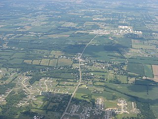
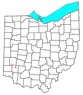
Red Lion is an unincorporated community in southwestern Clearcreek Township, Warren County, Ohio, United States, at the intersection of State Routes 741, 122, and 123. Red Lion is approximately five miles south of Springboro and five miles northwest of Lebanon.

Pekin is an unincorporated community in Clearcreek Township, Warren County, Ohio, United States, at the intersection of State Route 48 and Pekin Road. Pekin is approximately 3 miles south of Springboro and 7 miles northwest of Lebanon.

Moats is an unincorporated community in Defiance County, in the U.S. state of Ohio.

Edwardsville is an unincorporated community in Warren County, in the U.S. state of Ohio. Edwardsville is the oldest community in Harlan Township.

Mount Holly is an unincorporated community in Warren County, in the U.S. state of Ohio.

Rossburg is an unincorporated community in Warren County, in the U.S. state of Ohio.

Shaker Creek is a stream in the U.S. state of Ohio. The 8.7-mile (14.0 km) long stream empties into Dicks Creek.

Reeders Run is a stream in the U.S. state of Ohio. It is a tributary to Turtle Creek.

Jonahs Run is a stream in the U.S. state of Ohio. It is a tributary to Caesar Creek.

Newman Run is a stream in the U.S. state of Ohio. It is a tributary to the Little Miami River.

Martins Run is a stream in the U.S. state of Ohio.

Blackhawk is an unincorporated community in Warren County, in the U.S. state of Ohio. A variant spelling is "Black Hawk".

Wellman is an unincorporated community in Massie Township, Warren County, in the U.S. state of Ohio.

References

  1. U.S. Geological Survey Geographic Names Information System: Socialville, Ohio
  2. "Warren County, Ohio Place Names". Warren County Genealogical Society. Archived from the original on 13 March 2018. Retrieved 13 March 2018.CS1 maint: BOT: original-url status unknown (link)
  3. "Warren County". Jim Forte Postal History. Retrieved 17 January 2016.
  4. The History of Warren County, Ohio: Containing a History of the County ; Its Townships, Towns ; General and Local Statistics. W.H. Beers & Company. 1882. p. 646.

Coordinates: 39°19′10″N84°19′54″W / 39.31944°N 84.33167°W / 39.31944; -84.33167

Geographic coordinate system Coordinate system

A geographic coordinate system is a coordinate system that enables every location on Earth to be specified by a set of numbers, letters or symbols. The coordinates are often chosen such that one of the numbers represents a vertical position and two or three of the numbers represent a horizontal position; alternatively, a geographic position may be expressed in a combined three-dimensional Cartesian vector. A common choice of coordinates is latitude, longitude and elevation. To specify a location on a plane requires a map projection.