
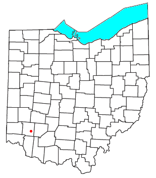
Warren County is a county located in the southwestern part of the U.S. state of Ohio. As of the 2020 census, the population was 242,337. Its county seat is Lebanon and largest city is Mason. The county is one of Ohio's most affluent, with the highest median income of the state's 88 counties. The county was established on May 1, 1803, from Hamilton County; it is named for Dr. Joseph Warren, a hero of the Revolution who sent Paul Revere and the overlooked William Dawes on their famous rides and who died at the Battle of Bunker Hill. Warren County is part of the Cincinnati, OH-KY-IN Metropolitan Statistical Area.
The Mill Creek is a stream in southwest Ohio. It flows 28.4 miles (45.7 km) southwest and south from its headwaters in Liberty Township of Butler County through central Hamilton County and the heart of Cincinnati into the Ohio River just west of downtown. The section of Interstate 75 through Cincinnati is known as the Mill Creek Expressway.

The Little Miami River is a Class I tributary of the Ohio River that flows 111 miles (179 km) through five counties in southwestern Ohio in the United States. The Little Miami joins the Ohio River east of Cincinnati. It forms parts of the borders between Hamilton and Clermont counties and between Hamilton and Warren counties. The Little Miami River is one of 156 American rivers designated by the U.S. Congress or the Secretary of the Interior as a National Wild and Scenic River and lends its name to the adjacent Little Miami Scenic Trail.

The Symmes Purchase, also known as the Miami Purchase, was an area of land totaling roughly 311,682 acres in what is now Hamilton, Butler, and Warren counties of southwestern Ohio, purchased by Judge John Cleves Symmes of New Jersey in 1788 from the Continental Congress.
Turtlecreek Township is one of the eleven townships of Warren County, Ohio, United States. It is in the central part of the county and surrounds the county seat of Lebanon. Turtlecreek is the largest township in the county, originally containing sixty-three whole and seven fractional sections. The population was 17,644 as of the 2020 census.

Clearcreek Township is one of the eleven townships of Warren County, Ohio, United States, located in the north central portion of the county. It had a population of 36,238 in 2020. It was originally about forty-two square miles in area. The highest point in the county is in Clearcreek Township, near the community of Five Points. Statewide, the only other Clearcreek Townships are located in Fairfield County and in Ashland County.
The Little Miami Railroad was a railway of southwestern Ohio, running from the eastern side of Cincinnati to Springfield, Ohio. By merging with the Columbus and Xenia Railroad in 1853, it created the first through-rail route from the important manufacturing city of Cincinnati to the state capital, Columbus. In this period, railroads were important for creating connections between the important waterways of the Great Lakes and the Ohio River, which were major transportation routes for products to other markets.

Washington Township is one of the eleven townships of Warren County, Ohio, United States. Located in the east-central part of the county, it is the only one of the eleven that does not contain a municipality. The population was 2,752 at the 2020 census.

Cozaddale is an unincorporated community in southeastern Hamilton Township, Warren County, Ohio, United States. It is two miles west of Pleasant Plain, and three miles north of Goshen, Ohio.

Oregonia is an unincorporated community in northwestern Washington Township, Warren County, Ohio, United States, on the east shore of the Little Miami River about five miles northeast of Lebanon and six miles south of Waynesville. The ZIP Code for Oregonia is 45054.
Hammel and Millgrove are extinct towns in western Warren County, Ohio, United States. They are located along the Little Miami River, about 2 miles (3 km) south of Fort Ancient and 1 mile north of Roachester at the Strout Road crossing of the river. Hammel lies on the eastern shore of the river, in southwestern Washington Township, and Millgrove lies on the western shore of the river, in northeastern Salem Township.
Fort Ancient is a Native American earthworks complex located in Washington Township, Warren County, Ohio, along the eastern shore of the Little Miami River about seven miles (11 km) southeast of Lebanon on State Route 350. The site is the largest prehistoric hilltop enclosure in the United States with three and one-half miles (18,000 ft) of walls in a 100-acre (0.40 km2) complex. Built by the Hopewell culture, who lived in the area from the 200 BC to AD 400, the site is situated on a wooded bluff 270 feet (82 m) above the Little Miami. It is the namesake of a culture known as Fort Ancient who lived near the complex long after it was constructed.

Fosters is an unincorporated community in southern Warren County, Ohio, United States. It straddles the Little Miami River in Deerfield and Hamilton Townships. It is located about two miles southwest of Hopkinsville, two miles west of Maineville, and two miles northeast of Twenty Mile Stand just off U.S. Route 22/State Route 3, the 3C Highway. The community is in the Kings Local School District and is served by the Maineville post office. The settlement was originally called Foster's Crossing. The community was named after the local Foster family.
The Middletown and Cincinnati Railroad is a historic railroad that operated in the southwest portion of the U.S. state of Ohio.

The Warren County Canal was a branch of the Miami and Erie Canal in southwestern Ohio about 20 miles (32 km) in length that connected the Warren County seat of Lebanon to the main canal at Middletown in the mid-19th century. Lebanon was at the crossroads of two major roads, the highway from Cincinnati to Columbus and the road from Chillicothe to the College Township (Oxford), but Lebanon businessmen and civic leaders wanted better transportation facilities and successfully lobbied for their own canal, part of the canal fever of the first third of the 19th century. The Warren County Canal was never successful, operating less than a decade before the state abandoned it.

The Lebanon Countryside Trail is a rail trail in Ohio.

Harker's Run is a stream originating in Preble County, Ohio. Harker's Run drains into Four Mile Creek on the eastern edge of the campus of Miami University in Oxford just north of where the Trenton Oxford Road crosses Four Mile/Talawanda Creek. The stream flows roughly from north to south, and is approximately 5.5 miles (8.9 km) in total length. The elevation at the mouth of the stream is 775 feet (236 m) above sea level. At its highest point, the stream is at approximately 1,000 feet (305 m) elevation. The stream is crossed by bridges on Bonham Road, Somerville Road, Hamilton Richmond Road, and Oxford Germantown Road.

San Mar Gale is an unincorporated community and was a planned development by the Hines-Griffin Land Development Company in Turtlecreek of Warren County, Ohio, United States. This 2500+ home planned unit development was approved by the Warren County Commissioners in February 2006. Zoning approval included a central business district and multi-family housing near the center. A public referendum challenging the approval was placed on the ballot in November 2006, and the Commissioners approval was ratified by voters. Construction was to have begun in 2007, however the development was cancelled as of February 2011.
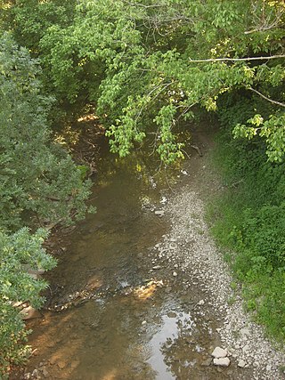
Turtle Creek is a 13.7-mile-long (22.0 km) tributary of the Little Miami River in Turtlecreek Township, Warren County, Ohio, which takes its name from this creek. Turtle Creek is named for Chief Little Turtle, of the Miami Indian Tribe Turtle Creek is a tributary within the Little Miami and Ohio River watersheds.
Branch Hill is an unincorporated community in Miami Township, Clermont County, Ohio, United States, on the banks of the Little Miami River near Loveland. The Little Miami Scenic Trail passes through Branch Hill.

