Related Research Articles
Beedles Station was the first settlement in what was to become Warren County, Ohio, United States. A blockhouse was established there in 1795 in what is now Section 28, Town 4, Range 3 of the Between the Miami Rivers Survey in western Turtlecreek Township. This is on the west side of State Route 741 about a mile south of Otterbein. The settlement was named for William Beedle, an early settler. A historical plaque marks the site.

Greentree Corners is an unincorporated community in northern Turtlecreek Township, Warren County, Ohio, United States. It is located at the intersection of State Route 741 and Greentree Road about one and one-half miles north of Otterbein, two miles south of Red Lion, and three miles northwest of Lebanon.

Zoar is an unincorporated community in northern Hamilton Township, Warren County, Ohio, United States. It is located on the 3C Highway about one mile east of Hopkinsville and three miles west of Morrow in Virginia Military District Military Survey 1546.

Dallasburg is an unincorporated community in southern Hamilton Township, Warren County, Ohio, United States. It is located in Virginia Military Reserve Military Survey 3790, about one mile west of Cozaddale and two miles southeast of Murdoch.

Level is an unincorporated community in southern Harlan Township, Warren County, Ohio, United States, which in the 19th century was a station on the Marietta and Cincinnati Railroad and had its own post office, since closed. According to the U.S. Geographic Names Information System (GNIS), an alternate name for this community is Windsor.
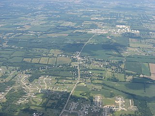
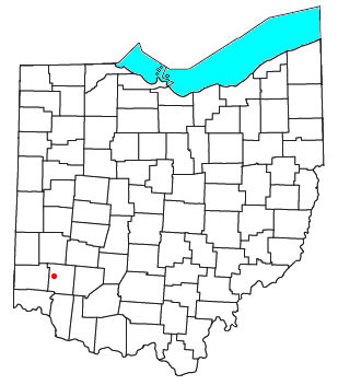
Red Lion is an unincorporated community in southwestern Clearcreek Township, Warren County, Ohio, United States, at the intersection of State Routes 741, 122, and 123. Red Lion is approximately five miles south of Springboro and five miles northwest of Lebanon.
Pekin is an unincorporated community in Clearcreek Township, Warren County, Ohio, United States, at the intersection of State Route 48 and Pekin Road. Pekin is approximately 3 miles south of Springboro and 7 miles northwest of Lebanon.
Edwardsville is an unincorporated community in Warren County, in the U.S. state of Ohio. Edwardsville is the oldest community in Harlan Township.
Mount Holly is an unincorporated community in Warren County, in the U.S. state of Ohio.
Rossburg is an unincorporated community in Warren County, in the U.S. state of Ohio.
Socialville is an unincorporated community in Warren County, in the U.S. state of Ohio.
Blackhawk is an unincorporated community in Warren County, in the U.S. state of Ohio. A variant spelling is "Black Hawk".
Butterworth is an extinct town in Warren County, Ohio.
Genntown is an unincorporated community in Warren County, in the U.S. state of Ohio.
Gum Grove is a small unincorporated community in Warren County, in the U.S. state of Ohio.
Hicks is an unincorporated community in Warren County, in the U.S. state of Ohio.
Merrittstown is an unincorporated community in Warren County, in the U.S. state of Ohio.
Middleboro is an unincorporated community in Warren County, in the U.S. state of Ohio.
Osceola is an unincorporated community in Warren County, in the U.S. state of Ohio.
Wellman is an unincorporated community in Massie Township, Warren County, in the U.S. state of Ohio.
References
- ↑ U.S. Geological Survey Geographic Names Information System: Venable (historical)
- ↑ "Warren County, Ohio Place Names". Warren County Genealogical Society. Archived from the original on March 13, 2018. Retrieved March 13, 2018.
Municipalities and communities of Warren County, Ohio, United States | ||
|---|---|---|
| Cities |  | |
| Villages | ||
| Townships | ||
| CDPs | ||
| Unincorporated communities |
| |
| Ghost towns | ||
| Footnotes | ‡This populated place also has portions in an adjacent county or counties | |
39°31′40″N84°08′46″W / 39.52778°N 84.14611°W
| | This Warren County, Ohio state location article is a stub. You can help Wikipedia by expanding it. |