Related Research Articles

Clearcreek Township is one of the eleven townships of Warren County, Ohio, United States, located in the north central portion of the county. It had a population of 36,238 in 2020. It was originally about forty-two square miles in area. The highest point in the county is in Clearcreek Township, near the community of Five Points. Statewide, the only other Clearcreek Townships are located in Fairfield County and in Ashland County.

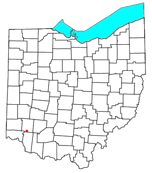
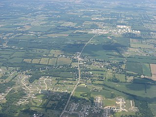
Hagemans Crossing is an unincorporated community in Union Township, Warren County, Ohio, United States. Located in the western part of the township, it is located on the old Cincinnati and Xenia Pike, now U.S. Route 42, about halfway between Lebanon and Mason. It was at the crossing of the Middletown and Cincinnati Railroad and the Cincinnati, Lebanon and Northern Railway and was about two miles northwest of the M&C's eastern terminus at Middletown Junction.

Cozaddale is an unincorporated community in southeastern Hamilton Township, Warren County, Ohio, United States. It is two miles west of Pleasant Plain, and three miles north of Goshen, Ohio.

Greentree Corners is an unincorporated community in northern Turtlecreek Township, Warren County, Ohio, United States. It is located at the intersection of State Route 741 and Greentree Road about one and one-half miles north of Otterbein, two miles south of Red Lion, and three miles northwest of Lebanon.

Zoar is an unincorporated community in northern Hamilton Township, Warren County, Ohio, United States. It is located on the 3C Highway about one mile east of Hopkinsville and three miles west of Morrow in Virginia Military District Military Survey 1546.
Murdoch is an unincorporated community in southern Hamilton Township, Warren County, Ohio, United States. It is located about two miles southeast of Maineville and two miles northwest of Cozaddale.

Dallasburg is an unincorporated community in southern Hamilton Township, Warren County, Ohio, United States. It is located in Virginia Military Reserve Military Survey 3790, about one mile west of Cozaddale and two miles southeast of Murdoch.

Dodds is an unincorporated community in eastern Clearcreek Township, Warren County, Ohio, United States, formerly on the Cincinnati, Lebanon and Northern Railway.

Level is an unincorporated community in southern Harlan Township, Warren County, Ohio, United States, which in the 19th century was a station on the Marietta and Cincinnati Railroad and had its own post office, since closed. According to the U.S. Geographic Names Information System (GNIS), an alternate name for this community is Windsor.
Red Lion is an unincorporated community in southwestern Clearcreek Township, Warren County, Ohio, United States, at the intersection of State Routes 741, 122, and 123. Red Lion is approximately five miles south of Springboro and five miles northwest of Lebanon.
Gillivan is an unincorporated community in Jefferson Township, Madison County, Ohio, United States. It is located at 39°59′19″N83°20′13″W, along U.S. Route 42, north of its intersection with Ohio State Route 29.
Pekin is an unincorporated community in Clearcreek Township, Warren County, Ohio, United States, at the intersection of State Route 48 and Pekin Road. Pekin is approximately 3 miles south of Springboro and 7 miles northwest of Lebanon.

Clear Creek is a tributary of the Great Miami River in southwestern Ohio. The creek forms in the southeastern portion of Clearcreek Township, with major tributaries including Mad Run, Beech Run, Bull Run, Richards Run, Twin Creek, Gander Run, Goose Run, and Dearth Run. The watershed includes the highest point in Warren County east of Five Points. It drains most of Clearcreek Township, Springboro, Ohio, much of Franklin Township, and then discharges into the Great Miami River in Franklin, Ohio.
Mount Holly is an unincorporated community in Warren County, in the U.S. state of Ohio.
Rossburg is an unincorporated community in Warren County, in the U.S. state of Ohio.
Socialville is an unincorporated community in Warren County, in the U.S. state of Ohio.
Blackhawk is an unincorporated community in Warren County, in the U.S. state of Ohio. A variant spelling is "Black Hawk".
Butterworth is an extinct town in Warren County, Ohio.
Gum Grove is a small unincorporated community in Warren County, in the U.S. state of Ohio.
Wellman is an unincorporated community in Massie Township, Warren County, in the U.S. state of Ohio.
References
- ↑ U.S. Geological Survey Geographic Names Information System: Edwardsville, Ohio
- ↑ "Warren County, Ohio Place Names". Warren County Genealogical Society. Archived from the original on March 13, 2018. Retrieved March 13, 2018.
- ↑ The History of Warren County, Ohio: Containing a History of the County ; Its Townships, Towns ; General and Local Statistics. W.H. Beers & Company. 1882. p. 647.
- ↑ "Warren County". Jim Forte Postal History. Archived from the original on January 22, 2016. Retrieved January 17, 2016.
Municipalities and communities of Warren County, Ohio, United States | ||
|---|---|---|
| Cities |  | |
| Villages | ||
| Townships | ||
| CDPs | ||
| Unincorporated communities |
| |
| Ghost towns | ||
| Footnotes | ‡This populated place also has portions in an adjacent county or counties | |
39°20′13″N84°01′39″W / 39.33694°N 84.02750°W
| | This Warren County, Ohio state location article is a stub. You can help Wikipedia by expanding it. |