Monroe, Ohio

Last updated

Monroe, Ohio
Hughes Manor.jpg
Flag of Monroe, Ohio.png
Seal of Monroe, Ohio.png
Logo of Monroe, Ohio.png
Motto: 
"Firmly Founded - Proudly Growing"
OHMap-doton-Monroe.png
Location of Monroe, Ohio
Map of Butler County Ohio Highlighting Monroe City.png
Location of Monroe in Butler County
Coordinates: 39°26′46″N84°22′00″W / 39.44611°N 84.36667°W / 39.44611; -84.36667
Country United States
State Ohio
Counties Butler, Warren
Government
  MayorKeith Funk [1]
Area
[2]
  Total15.91 sq mi (41.22 km2)
  Land15.89 sq mi (41.16 km2)
  Water0.02 sq mi (0.06 km2)
Elevation
[3]
820 ft (250 m)
Population
 (2020)
  Total15,412
  Density969.92/sq mi (374.48/km2)
Time zone UTC-5 (Eastern (EST))
  Summer (DST) UTC-4 (EDT)
ZIP codes
45050, 45044 (pt), 45073, 45099
Area code 513
FIPS code 39-51310 [4]
GNIS feature ID2395374 [3]
Website City website

Monroe is a city in east central Butler and west central Warren counties in the southwestern part of the U.S. state of Ohio. The population was 15,412 at the 2020 census. Monroe is a part of the Cincinnati metropolitan area.

Contents

History

Monroe was laid out in 1817 on the Dayton and Cincinnati pike. [5] The city is named for President James Monroe, fifth President of the United States. [6]

In the early 1830s, Monroe contained one store and 119 inhabitants. [7]

Geography

According to the United States Census Bureau, the city has a total area of 15.89 square miles (41.15 km2), of which 15.87 square miles (41.10 km2) is land and 0.02 square miles (0.05 km2) is water. [8]

Demographics

Historical population
CensusPop.Note
1850 198
1870 324
1880 36512.7%
1910 255
1920 2664.3%
1930 2857.1%
1940 3077.7%
1950 36017.3%
1960 2,193509.2%
1970 3,49259.2%
1980 4,25621.9%
1990 4,4905.5%
2000 7,13358.9%
2010 12,44274.4%
2020 15,41223.9%
2021 (est.)15,4480.2%
Sources: [4] [9] [10] [11] [12] [13] [14] [15]

2010 census

As of the census [16] of 2010, there were 12,442 people, 4,649 households, and 3,481 families living in the city. The population density was 784.0 inhabitants per square mile (302.7/km2). There were 4,896 housing units at an average density of 308.5 per square mile (119.1/km2). The racial makeup of the city was 92.6% White, 3.7% African American, 0.2% Native American, 1.7% Asian, 0.7% from other races, and 1.3% from two or more races. Hispanic or Latino of any race were 1.8% of the population.

There were 4,649 households, of which 39.2% had children under the age of 18 living with them, 61.6% were married couples living together, 8.8% had a female householder with no husband present, 4.5% had a male householder with no wife present, and 25.1% were non-families. 21.3% of all households were made up of individuals, and 10.1% had someone living alone who was 65 years of age or older. The average household size was 2.63 and the average family size was 3.07.

The median age in the city was 36.9 years. 27% of residents were under the age of 18; 5.9% were between the ages of 18 and 24; 29.7% were from 25 to 44; 23.1% were from 45 to 64; and 14.3% were 65 years of age or older. The gender makeup of the city was 48.8% male and 51.2% female.

2000 census

As of the census [4] of 2000, there were 7,133 people, 2,685 households, and 2,040 families living in the city. The population density was 459.9 inhabitants per square mile (177.6/km2). There were 2,822 housing units at an average density of 182.0 per square mile (70.3/km2). The racial makeup of the city was 97.15% White, 1.42% African American, 0.10% Native American, 0.34% Asian, 0.22% from other races, and 0.77% from two or more races. Hispanic or Latino of any race were 0.64% of the population.

There were 2,685 households, out of which 32.4% had children under the age of 18 living with them, 65.1% were married couples living together, 6.9% had a female householder with no husband present, and 24.0% were non-families. 20.3% of all households were made up of individuals, and 9.3% had someone living alone who was 65 years of age or older. The average household size was 2.52 and the average family size was 2.91.

In the city the population was spread out, with 22.8% under the age of 18, 6.5% from 18 to 24, 29.1% from 25 to 44, 22.6% from 45 to 64, and 19.0% who were 65 years of age or older. The median age was 40 years. For every 100 females, there were 91.7 males. For every 100 females age 18 and over, there were 88.3 males.

The median income for a household in the city was $56,012, and the median income for a family was $62,528. Males had a median income of $44,864 versus $27,385 for females. The per capita income for the city was $24,735. About 1.0% of families and 1.9% of the population were below the poverty line, including 0.4% of those under age 18 and 2.1% of those age 65 or over.

Schools and utilities

Most of the city is in the Monroe Local School District with some falling in the Lakota Local School District. Telephone service is provided through the Monroe, Middletown, and Mason exchanges. Mail is delivered through the Monroe, Middletown, and Lebanon post offices. There is both a police station and a fire station on Main St. as well as the fire headquarters on Rt. 4.

Tourism

Notable people

Related Research Articles

<span class="mw-page-title-main">Richland County, Ohio</span> County in Ohio, United States

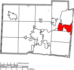
Richland County is a county located in the U.S. state of Ohio. As of the 2020 census, the population was 124,936. Its county seat is Mansfield. The county was created in 1808 and later organized in 1813. It is named for the fertile soil found there. Richland County is included in the Mansfield, OH Metropolitan Statistical Area as well as the Mansfield-Ashland-Bucyrus, OH Combined Statistical Area. The county is one of the six Metropolitan Statistical Areas that make up Northeast Ohio.

<span class="mw-page-title-main">Noble County, Ohio</span> County in Ohio, United States

Noble County is a county located in the U.S. state of Ohio. As of the 2020 census, the population was 14,115, making it the fourth-least populous county in Ohio. Its county seat is Caldwell. The county is named for Rep. Warren P. Noble of the Ohio House of Representatives, who was an early settler there.

<span class="mw-page-title-main">Monroe County, Ohio</span> County in Ohio, United States

Monroe County is a county located on the eastern border of the U.S. state of Ohio, across the Ohio River from West Virginia. As of the 2020 census, the population was 13,385, making it the second-least populous county in Ohio. Its county seat is Woodsfield. The county was created in 1813 and later organized in 1815.

<span class="mw-page-title-main">Darke County, Ohio</span> County in Ohio, United States

Darke County is a county in the U.S. state of Ohio. As of the 2020 census, the population was 51,881. Its county seat and largest city is Greenville. The county was created in 1809 and later organized in 1817. It is named for William Darke, an officer in the American Revolutionary War. Darke County comprises the Greenville, OH Micropolitan Statistical Area, which is also included in the Dayton-Springfield-Sidney, OH Combined Statistical Area.

<span class="mw-page-title-main">Butler County, Ohio</span> County in Ohio, United States

Butler County is a county located in the southwestern part of the U.S. state of Ohio. As of the 2020 census, the population was 390,357. Its county seat and largest city is Hamilton. It is named for General Richard Butler, who died in 1791 during St. Clair's Defeat. Located along the Great Miami River, it is also home to Miami University, a public university founded in 1809. Butler County is part of the Cincinnati, OH-KY-IN Metropolitan Statistical Area. The majority of the county is in District 52 of the State House.

<span class="mw-page-title-main">Petersburg, Michigan</span> City in Michigan, United States

Petersburg is a city in Monroe County in the U.S. state of Michigan. The population was 1,171 at the 2020 census.

<span class="mw-page-title-main">Jacksonburg, Ohio</span> Village in Ohio, United States

Jacksonburg is a small village in Butler County, Ohio, United States. The population was 55 at the 2020 census.

<span class="mw-page-title-main">Millville, Ohio</span> Village in Ohio, United States

Millville is a village in Butler County, Ohio, United States. The population was 634 at the 2020 census. Millville sits between Oxford, Ohio and Cincinnati, Ohio along U.S. Route 27.

<span class="mw-page-title-main">Somerville, Ohio</span> Census-designated place in Ohio, United States

Somerville is a census-designated place (CDP) and former village in Milford Township, Butler County, Ohio, United States. The population was 258 at the 2020 census.

<span class="mw-page-title-main">Trenton, Ohio</span> City in Ohio, United States

Trenton is a city in northeastern Butler County, Ohio, United States, west of Middletown. The population was 13,021 at the 2020 census. It is part of the Cincinnati metropolitan area.

<span class="mw-page-title-main">Pitsburg, Ohio</span> Village in Ohio, United States

Pitsburg is a village in Monroe Township, Darke County, Ohio, United States. The population was 381 at the 2020 census.

<span class="mw-page-title-main">Harrison, Ohio</span> City in Ohio, United States

Harrison is a city in western Hamilton County, Ohio, United States. The population was 12,563 at the 2020 census. It is part of the Cincinnati metropolitan area.

<span class="mw-page-title-main">Springdale, Ohio</span> City in Ohio, United States

Springdale is a city in Hamilton County, Ohio, United States. It is a suburb of Cincinnati. The population was 11,007 at the 2020 census.

<span class="mw-page-title-main">Monroeville, Ohio</span> Village in Ohio, United States

Monroeville is a village in Huron County, Ohio, United States. The population was 1,300 at the 2020 census.

<span class="mw-page-title-main">Johnstown, Ohio</span> City in Ohio, United States

Johnstown is a city in Licking County, Ohio, United States. The population was 5,278 at the 2022 census. The city is most notable for the Johnnies-Vikings rivalry and the finding of a nearly complete mastodon skeleton under the city.

<span class="mw-page-title-main">Woodsfield, Ohio</span> Village in Ohio, United States

Woodsfield is a village and the county seat of Monroe County, Ohio, United States, located about 30 miles (48 km) northeast of Marietta. The population was 2,210 at the 2020 census.

<span class="mw-page-title-main">Clinton Township, Butler County, Pennsylvania</span> Township in Pennsylvania, United States

Clinton Township is a township in Butler County, Pennsylvania, United States. The population was 2,913 at the 2020 census. For generations, it was home to a U.S. Steel plant.

<span class="mw-page-title-main">Middletown, Ohio</span> City in Ohio, United States

Middletown is a city located in Butler and Warren counties in the southwestern part of the U.S. state of Ohio. The population as of the 2020 census was 50,987. It is part of the Cincinnati metropolitan area, located 29 miles (47 km) northeast of Cincinnati and 20 miles (32 km) southwest of Dayton.

<span class="mw-page-title-main">Union, Ohio</span> City in Ohio, United States

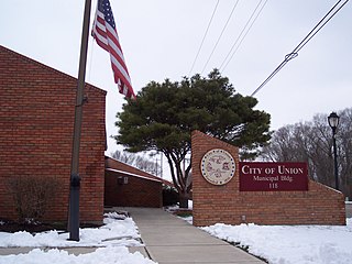
Union is a city in Montgomery and Miami Counties in the U.S. state of Ohio. The population was 6,859 at the time of the 2020 census. It is part of the Dayton Metropolitan Statistical Area.

<span class="mw-page-title-main">Summerfield Township, Monroe County, Michigan</span> Civil township in Michigan, United States

Summerfield Township is a civil township of Monroe County in the U.S. state of Michigan. The population was 3,176 at the 2020 census.

References

  1. "Mayor & Council". Monroe, OH Official Website. City of Monroe, OH. Retrieved July 17, 2022.
  2. "ArcGIS REST Services Directory". United States Census Bureau. Retrieved September 20, 2022.
  3. 1 2 U.S. Geological Survey Geographic Names Information System: Monroe, Ohio
  4. 1 2 3 "U.S. Census website". United States Census Bureau . Retrieved January 31, 2008.
  5. Bartlow, Bert Surene (1905). Centennial History of Butler County, Ohio. B. F. Bowen. p. 340.
  6. Overman, William Daniel (1958). Ohio Town Names. Akron, OH: Atlantic Press. p. 90.
  7. Kilbourn, John (1833). The Ohio Gazetteer, or, a Topographical Dictionary. Scott and Wright. pp.  321 . Retrieved December 12, 2013.
  8. "US Gazetteer files 2010". United States Census Bureau. Archived from the original on April 1, 2013. Retrieved January 6, 2013.
  9. "Population of Civil Divisions Less than Counties" (PDF). Statistics of the Population of the United States at the Ninth Census. U.S. Census Bureau. 1870. Retrieved April 24, 2020.
  10. "Population of Civil Divisions Less than Counties" (PDF). Statistics of the Population of the United States at the Tenth Census. U.S. Census Bureau. 1880. Retrieved November 28, 2013.
  11. "Population: Ohio" (PDF). 1910 U.S. Census. U.S. Census Bureau. Retrieved November 28, 2013.
  12. "Population: Ohio" (PDF). 1930 US Census. U.S. Census Bureau. Retrieved November 28, 2013.
  13. "Number of Inhabitants: Ohio" (PDF). 18th Census of the United States. U.S. Census Bureau. 1960. Retrieved April 24, 2020.
  14. "Ohio: Population and Housing Unit Counts" (PDF). U.S. Census Bureau. Retrieved November 22, 2013.
  15. "Monroe city, Ohio". census.gov. Retrieved July 5, 2022.
  16. "U.S. Census website". United States Census Bureau . Retrieved January 6, 2013.