
Warren County is a county located in the southwestern part of the U.S. state of Ohio. As of the 2010 census, the population was 212,693. Its county seat is Lebanon. The county was created on May 1, 1803 from Hamilton County; it is named for Dr. Joseph Warren, a hero of the Revolution who sent Paul Revere and the overlooked William Dawes on their famous rides and who died at the Battle of Bunker Hill. Warren County is part of the Cincinnati, OH-KY-IN Metropolitan Statistical Area.
Turtlecreek Township is one of the eleven townships of Warren County, Ohio, United States. It is in the central part of the county and surrounds the county seat of Lebanon. Turtlecreek is the largest township in the county, originally containing sixty-three whole and seven fractional sections. It had a population of 12,617 in 2000, up from 10,383 in 1990. Of those, 12,114 lived in the unincorporated part of the township, 456 in Middletown, and 47 in Monroe.

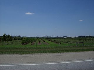
Clearcreek Township is one of the eleven townships of Warren County, Ohio, United States, located in the north central portion of the county. It had a population of 20,974 in 2000, up from 13,344 in 1990; of this total, 8,747 lived in the unincorporated portions of the township. It was originally about forty-two square miles in area. The highest point in the county is in Clearcreek Township, near the community of Five Points. Statewide, the only other Clearcreek Townships are located in Fairfield County and in Ashland County.

Union Township is one of the eleven townships of Warren County, Ohio, United States, located in the central part of the county. It was established January 3, 1815 and named Union as it was formed from parts of Deerfield and Turtlecreek Townships. The 2000 census found 4,668 people in the township, up slightly from the 4,631 in 1990. Of those, 2,230 lived in the unincorporated part of the township and 2,438 lived in the village of South Lebanon.

Salem Township is one of the eleven townships of Warren County, Ohio, United States, located in the central part of the county. The 2000 census found 4,133 people in the township, up slightly from the 4,038 in 1990; of this total, 2,847 lived in the unincorporated portions of the township. It is the second smallest township in the county with 13,459 acres (54 km2). It is one of fourteen Salem Townships statewide.
Wayne Township is one of the eleven townships of Warren County, Ohio, United States. It is located in the northeast part of the county and includes the village of Waynesville, Ohio. Its population in 2000 was 7,250, up from 5,744 in 1990; 4,436 of this total lived in the unincorporated portions of the township. Waynesville is noted for its antique stores and is the home of a sauerkraut festival. Caesar Creek State Park is located here.

Massie Township, one of the eleven townships of Warren County, Ohio, United States, is located in the northeast part of the county and the least populous of Warren County's townships. In 2000, the population was 1,061 up from 885 in 1990; of this total, 498 lived in the unincorporated portions of the township. The third smallest township in the county with 13,622 acres (55 km2); it is the only Massie Township statewide. It is the home of the Ohio Renaissance Festival and Caesar Creek State Park.
Harlan Township, one of the eleven townships of Warren County, Ohio, United States, and the last to be formed in that county, is located in the southeast corner of the county. The 2000 census found 3,627 inhabitants, up from 3,268 in 1990; of this total, 3,240 lived in the unincorporated portions of the township.

Hamilton Township, one of the eleven townships of Warren County, Ohio, United States, is in the south central portion of the county. The 2000 census found 9,630 people there, up significantly from the 5,900 in 1990. 8,645 of the total in 2000 lived in the unincorporated portions of the township. It is the fastest growing area of Warren County and is about 36 miles² (93 km2) in area.
Franklin Township, one of the eleven townships of Warren County, Ohio, United States, is in the northwest corner of the county. It is the most populous township in the county: the 2000 census found 27,294 people there, down from 27,510 in 1990; of this total, 9,947 lived in the unincorporated portions of the township.

Deerfield Township, one of the eleven townships of Warren County, Ohio, United States, is located in the southwest corner of the county and is part of the Cincinnati, Ohio MSA. The population, according to the latest American Community Survey is 38,217, making it the most populous jurisdiction in Warren County, Ohio.

Adams Township is one of the thirteen townships of Clinton County, Ohio, United States. As of the 2010 census the population was 2,091.

Chester Township is one of the thirteen townships of Clinton County, Ohio, United States. As of the 2010 census the population was 1,967.

Vernon Township is one of the thirteen townships of Clinton County, Ohio, United States. The 2010 census reported 2,997 people living in the township, 2,449 of whom were in the unincorporated portions.

Marion Township is one of the thirteen townships of Clinton County, Ohio, United States. The 2010 census reported 5,394 people living in the township, 1,151 of whom lived in the unincorporated portions.

Washington Township is the largest of nine townships of Montgomery County, Ohio, United States. As of the 2010 census, the population was 56,607, with 32,610 persons residing within the unincorporated portion of the township, and 23,997 persons residing within the city of Centerville.

Orange Township is one of the fourteen townships of Shelby County, Ohio, United States. The 2000 census found 1,419 people in the township.

Washington Township is one of the fourteen townships of Shelby County, Ohio, United States. The 2000 census found 2,083 people in the township, 1,875 of whom lived in the unincorporated portions of the township.

Marietta Township is one of the twenty-two townships of Washington County, Ohio, United States. The 2000 census found 4,673 people in the township.
Spring Valley Township is one of twelve townships of Greene County, Ohio, United States. As of the 2010 census, the population was 2,581, of whom 2,105 lived in the unincorporated portion of the township.


