Landen, Ohio

Last updated

Landen, Ohio
CDP
OHMap-doton-Landen.png
Location of Landen, Ohio
Coordinates: 39°18′56″N84°16′36″W / 39.31556°N 84.27667°W / 39.31556; -84.27667
Country United States
State Ohio
County Warren
Area
[1]
  Total2.12 sq mi (5.49 km2)
  Land2.03 sq mi (5.25 km2)
  Water0.09 sq mi (0.24 km2)
Elevation
[2]
817 ft (249 m)
Population
 (2020)
  Total6,995
  Density3,449.21/sq mi (1,331.85/km2)
Time zone UTC-5 (Eastern (EST))
  Summer (DST) UTC-4 (EDT)
FIPS code 39-41755 [3]
GNIS feature ID2393093 [2]

Landen is a census-designated place (CDP) in Deerfield Township, Warren County, Ohio, United States. The population was 6,995 at the 2020 census. It is located around Columbia Road and Montgomery Road in the southeastern part of the township. It surrounds Twenty Mile Stand and near Fosters.

Contents

Landen was named after Theodophilus James Landen, an early Ohio settler who owned the farmland surrounding Twenty Mile Stand. The man-made Landen Lake occupies the center of the residential area in the town. Though its formal place designation is "Landen Farm Drainage Lake", the reduction in farming activity in the immediate area of the lake has made it suitable for recreation. The lake was further improved with the completion in 2008 of a major dredging operation that removed 184,000 cubic yards of sediment from the lake.[ citation needed ]

Geography

According to the United States Census Bureau, the CDP has a total area of 4.8 square miles (12 km2), of which 4.7 square miles (12 km2) is land and 0.1 square miles (0.26 km2) (1.68%) is water.

Subdivisions in Landen

  • BayWood
  • BayView
  • CarriageGate
  • Chestnut Landing
  • Cobblefield
  • Creekwoods
  • Gatsby Green
  • Harbor Ridge
  • Heatherstone
  • Hickory View
  • Hunter's Pointe
  • The Islands
  • Island Pines
  • Landen Cove
  • The Meadows
  • Montgomery Hills
  • North Cove
  • North Shore
  • The Orchards
  • The Pointe of Landen
  • Pond Woods
  • RedBrick Court
  • Sailboat Pointe
  • South Cove
  • The Trails
  • Strawberry Hill
  • Vineyard Court
  • Woodfield

Schools

Landen Deerfield Park

Landen Deerfield Park is a 95-acre park located off U.S. Route 22 in Landen, OH. The park is home to 8 baseball fields, two playgrounds, a large lake for fishing, numerous hiking trails and a large area for soccer and football fields. [4] The park also offers an outdoor basketball court, two tennis courts, a concession stand, restrooms and shelters, along with picnic areas and grills. The park also features and open air amphitheater for plays and concerts.

Demographics

Historical population
CensusPop.Note
2020 6,995
U.S. Decennial Census [5]

As of the census [3] of 2000, there were 12,766 people, 4,905 households, and 3,448 families residing in the CDP. The population density was 2,729.7 inhabitants per square mile (1,053.9/km2). There were 5,162 housing units at an average density of 1,103.8 per square mile (426.2/km2). The racial makeup of the CDP was 93.86% White, 1.48% African American, 0.09% Native American, 2.70% Asian, 0.10% Pacific Islander, 0.78% from other races, and 0.99% from two or more races. Hispanic or Latino of any race were 2.18% of the population.

There were 4,905 households, out of which 40.1% had children under the age of 18 living with them, 61.1% were married couples living together, 6.7% had a female householder with no husband present, and 29.7% were non-families. 23.5% of all households were made up of individuals, and 3.3% had someone living alone who was 65 years of age or older. The average household size was 2.60 and the average family size was 3.14.

In the CDP, the population was spread out, with 29.3% under the age of 18, 6.5% from 18 to 24, 38.7% from 25 to 44, 20.4% from 45 to 64, and 5.1% who were 65 years of age or older. The median age was 34 years. For every 100 females, there were 99.3 males. For every 100 females age 18 and over, there were 96.1 males.

The median income for a household in the CDP was $67,562, and the median income for a family was $78,236. Males had a median income of $52,446 versus $35,264 for females. The per capita income for the CDP was $32,861. About 1.2% of families and 2.5% of the population were below the poverty line, including 2.3% of those under age 18 and 1.9% of those age 65 or over.

Related Research Articles

<span class="mw-page-title-main">Landmark, Arkansas</span> CDP in Arkansas, United States

Landmark is a census-designated place (CDP) in Pulaski County, Arkansas, United States. Per the 2020 census, the population was 3,585. It is part of the Little Rock–North Little Rock–Conway Metropolitan Statistical Area.

<span class="mw-page-title-main">Woodside East, Delaware</span> CDP in Delaware, United States

Woodside East is a census-designated place (CDP) in Kent County, Delaware, United States. It is part of the Dover, Delaware Metropolitan Statistical Area. The population was 2,316 at the 2010 census.

<span class="mw-page-title-main">Olympia Heights, Florida</span> Census-designated place in Florida

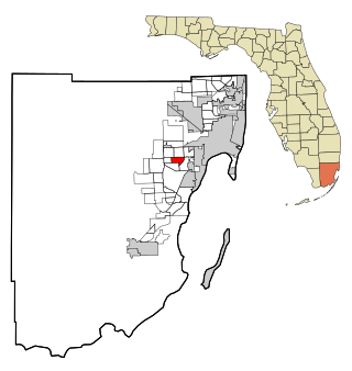
Olympia Heights is a census-designated place in Miami-Dade County, Florida, United States. It is located in the Miami metropolitan area of South Florida. The population was 12,873 at the 2020 census.

<span class="mw-page-title-main">Westwood Lakes, Florida</span> Census-designated place in Florida

Westwood Lakes is a census-designated place and unincorporated community of Miami-Dade County, Florida, United States. It is part of the Miami metropolitan area of South Florida. The population was 11,373 at the 2020 census.

<span class="mw-page-title-main">Inwood, Florida</span> Census-designated place in Florida, United States

Inwood is a census-designated place (CDP) in Polk County, Florida, United States. The population was 6,925 at the time of the 2000 United States Census. It is part of the Lakeland–Winter Haven Metropolitan Statistical Area.

<span class="mw-page-title-main">Candler-McAfee, Georgia</span> Place in Georgia, United States

Candler-McAfee is an unincorporated community and census-designated place (CDP) in DeKalb County, Georgia, United States. It is located east of Atlanta approximately 10 miles (16 km) east of Downtown Atlanta and to the south of Decatur, Georgia The population was 23,025 at the 2010 census.

<span class="mw-page-title-main">New Paris, Indiana</span> Census-designated place in Indiana, United States

New Paris is a census-designated place (CDP) in Elkhart County, Indiana, United States. The population was 1,494 at the 2010 census.

Moss Bluff is a census-designated place (CDP) in Calcasieu Parish, Louisiana, United States. The population was 12,522 at the 2020 census. Located just north of the city of Lake Charles, it is considered a suburb of that city. Moss Bluff is a burgeoning community, and is one of the communities in Calcasieu Parish besides Lake Charles and Sulphur experiencing growth. Several efforts have been made to incorporate Moss Bluff, but at the present time the community is unincorporated.

<span class="mw-page-title-main">Lake Shore, Maryland</span> Census-designated place in Maryland, United States

Lake Shore is a census-designated place and unincorporated community in Anne Arundel County, Maryland, United States, located east of Pasadena. The population of Lake Shore was 19,477 at the 2010 census.

<span class="mw-page-title-main">Pasadena, Maryland</span> Census-designated place in Maryland, United States

Pasadena is a census-designated place (CDP) in Anne Arundel County, Maryland, United States. The population was 24,287 at the 2010 census.

<span class="mw-page-title-main">Vandercook Lake, Michigan</span> Census-designated place & unincorporated community in Michigan, United States

Vandercook Lake is an unincorporated community and census-designated place (CDP) in Jackson County in the U.S. state of Michigan. The population of the CDP was 4,721 at the 2010 census. It is located within Summit Township.

<span class="mw-page-title-main">Twin Lakes, New Mexico</span> CDP in New Mexico, United States

Twin Lakes is a census-designated place (CDP) in McKinley County, New Mexico, United States. The population was 1,069 at the 2000 census.

<span class="mw-page-title-main">Ross, Ohio</span> Census-designated place in Ohio, United States

Ross is a census-designated place (CDP) in Ross Township, Butler County, Ohio, United States. The population was 3,478 at the 2020 census. Ross sits along U.S. Route 27 between Cincinnati, Ohio and Oxford, Ohio. Ross is part of the Cincinnati metropolitan area.

<span class="mw-page-title-main">Crystal Lakes, Ohio</span> Census-designated place in Ohio, United States

Crystal Lakes is a census-designated place (CDP) in Clark County, Ohio, United States. The population was 1,394 at the 2020 census. It is part of the Springfield, Ohio Metropolitan Statistical Area.

<span class="mw-page-title-main">Park Layne, Ohio</span> Census-designated place in Ohio, United States

Park Layne is a census-designated place (CDP) in Bethel Township, Clark County, Ohio, United States. The population of the CDP was 4,248 at the 2020 census. It is part of the Springfield, Ohio Metropolitan Statistical Area. Park Layne became a CDP in the 1980 United States Census.

<span class="mw-page-title-main">West Springfield, Virginia</span> Census-designated place in Virginia, United States

West Springfield is a census-designated place (CDP) in Fairfax County, Virginia, United States. The population was 23,369 at the 2020 census.

<span class="mw-page-title-main">Alum Creek, West Virginia</span> Census-designated place in West Virginia, United States

Alum Creek is a census-designated place (CDP) in Kanawha and Lincoln counties along the Coal River in the U.S. state of West Virginia. It includes the unincorporated communities of Alum Creek, Forks of Coal, and Priestley. The CDP had a population of 1,749 at the 2010 census, down from 1,839 at the 2000 census.

<span class="mw-page-title-main">Okauchee Lake, Wisconsin</span> CDP in Wisconsin, United States

Okauchee Lake is a census-designated place (CDP) in Waukesha County, Wisconsin, United States. The population was 5,094 at the 2020 census. Okauchee Lake is located in the town of Oconomowoc.

<span class="mw-page-title-main">Loveland Park, Ohio</span> Census-designated place in Ohio, United States

Loveland Park is a census-designated place (CDP) located in Symmes Township, Hamilton County and Deerfield Township, Warren County, in the southwestern part of the U.S. state of Ohio. The CDP is named after the city of Loveland. The population was 1,737 at the 2020 census.

<span class="mw-page-title-main">Kings Park West, Virginia</span> Census-designated place in Virginia, United States

Kings Park West is a census-designated place in the eastern United States, in Fairfax County, Virginia, southwest of Washington, D.C. At the 2020 census the population was 13,465 people

References

  1. "ArcGIS REST Services Directory". United States Census Bureau. Retrieved September 20, 2022.
  2. 1 2 U.S. Geological Survey Geographic Names Information System: Landen, Ohio
  3. 1 2 "U.S. Census website". United States Census Bureau . Retrieved January 31, 2008.
  4. Bureau, Warren County Convention and Visitors. "Landen Deerfield Park". www.ohioslargestplayground.com. Retrieved February 1, 2017.
  5. "Census of Population and Housing". Census.gov. Retrieved June 4, 2016.