
Franklin Furnace is a census-designated place (CDP) in Scioto County, Ohio, United States, along the Ohio River. The population was 1,660 at the 2010 census. Franklin Furnace's post office has the ZIP code of 45629.
Lewis Center is an unincorporated community in northwestern Orange Township, Delaware County, Ohio, United States, in the Columbus, OH Metropolitan Statistical Area.

Bascom is a census-designated place in western Hopewell Township, Seneca County, Ohio. It has a post office with the ZIP code 44809 and hosts Hopewell-Loudon High School. The community is located at the intersection of State Routes 18 and 635 east of Fostoria.
Jacksontown is a census-designated place (CDP) in central Licking Township, Licking County, Ohio, United States. It has a post office with the ZIP code 43030. It lies at the intersection of U.S. Route 40 with State Route 13.

Buford is an unincorporated community and census-designated place in central Clay Township, Highland County, Ohio, United States. The population was 306 at the 2020 census. It once had a post office, with the ZIP code 45110. The current ZIP code 45171 is for nearby Sardinia.

Parkman is a census-designated place in southern Parkman Township, Geauga County, Ohio, United States. It has a post office with the ZIP code 44080. It lies along U.S. Route 422 at its intersection with State Routes 88, 168, and 528.

Oceola is a census-designated place (CDP) in central Tod Township, Crawford County, Ohio, United States. As of the 2020 census its population was 156. It has a post office with the ZIP code 44860. It is located along the road that was U.S. Route 30 until being upgraded to a freeway.
Warnock is an unincorporated community in northern Smith Township, Belmont County, Ohio, United States. It has a post office with the ZIP code 43967. It lies along State Route 9.

Lafferty is a census-designated place in northeastern Union Township, Belmont County, Ohio, United States, along Wheeling Creek. As of the 2020 census it had a population of 255. It has a post office with the ZIP code 43951.

Glencoe is a census-designated place in southern Richland Township, Belmont County, Ohio, United States. As of the 2020 census it had a population of 264. It has a post office with the ZIP code 43928.
Colerain is an unincorporated community in eastern Colerain Township, Belmont County, Ohio, United States. It has a post office with the ZIP code 43916. It lies along U.S. Route 250.
Bannock is a census-designated place in northwestern Richland Township, Belmont County, Ohio, United States, along Wheeling Creek. As of the 2020 census it had a population of 159. It has a post office with the ZIP code 43972. It lies along State Route 331.

Ellsworth is an unincorporated community in central Ellsworth Township, Mahoning County, Ohio, United States. It is part of the Youngstown–Warren metropolitan area. It lies at the intersection of U.S. Route 224 and State Route 45, and has a post office with the ZIP code 44416.

Damascus is an unincorporated community and census-designated place in southern Mahoning and northern Columbiana counties in the U.S. state of Ohio. As of the 2020 census, it had a population of 418. The community lies at the intersection of U.S. Route 62 and State Routes 173 and 534.

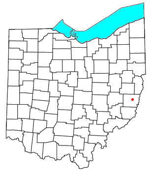
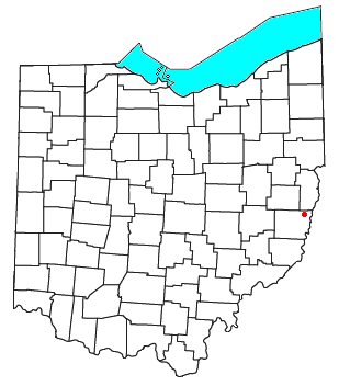
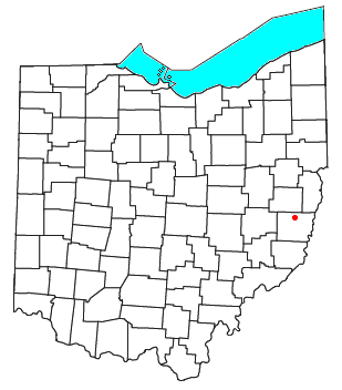
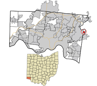
East Springfield is a census-designated place (CDP) in northwestern Salem Township, Jefferson County, Ohio, United States. It has a post office with the ZIP code 43925. It lies along State Route 43, 16 miles (26 km) northwest of the county seat of Steubenville and 17 miles (27 km) southeast of Carrollton. The community is part of the Weirton–Steubenville, WV-OH Metropolitan Statistical Area.

Miamitown is a census-designated place (CDP) in western Whitewater Township, Hamilton County, Ohio, United States. The population was 1,256 at the 2020 census. It has a post office with the ZIP code 45041.
Camp Dennison is a census-designated place (CDP) just outside Indian Hill in southern Symmes Township, Hamilton County, Ohio, United States. It has a post office with the ZIP code 45111. The population was 384 at the 2010 census.

East Rochester is an unincorporated community and census-designated place (CDP) in southern West Township, Columbiana County, Ohio, United States. The population was 224 as of the 2020 census. It lies along U.S. Route 30, and has a post office with the ZIP code 44625. It is a part of the Salem micropolitan area, about 20 miles (32 km) east of Canton.
Maceo is an unincorporated community and census-designated place (CDP) in Daviess County, Kentucky, United States. As of the 2010 census, it had a population of 413.
Pisgah is an unincorporated community in Butler County, in the U.S. state of Ohio.

