St. Louisville, Ohio

Last updated

St. Louisville, Ohio
St. Louisville post office 43071.jpg
Post office
OHMap-doton-St. Louisville.png
Location of St. Louisville, Ohio
Licking County, Ohio highlighting St. Louisville.svg
Location of St. Louisville in Licking County
Coordinates: 40°10′16″N82°25′05″W / 40.17111°N 82.41806°W / 40.17111; -82.41806
Country United States
State Ohio
County Licking
Area
[1]
  Total0.25 sq mi (0.66 km2)
  Land0.25 sq mi (0.66 km2)
  Water0.00 sq mi (0.00 km2)
Elevation
[2]
902 ft (275 m)
Population
 (2020)
  Total352
  Density1,391.30/sq mi (536.42/km2)
Time zone UTC-5 (Eastern (EST))
  Summer (DST) UTC-4 (EDT)
FIPS code 39-69652 [3]
GNIS feature ID2399168 [2]

St. Louisville or Saint Louisville [2] is a village in Licking County, Ohio, United States, along the North Fork of the Licking River. The population was 352 at the 2020 census.

Contents

St. Louisville was platted in 1839. [4]

Geography

According to the United States Census Bureau, the village has a total area of 0.25 square miles (0.65 km2), all land. [5]

Demographics

Historical population
CensusPop.Note
1850 109
1870 166
1880 21529.5%
1890 26422.8%
1900 2858.0%
1910 244−14.4%
1920 2637.8%
1930 30716.7%
1940 298−2.9%
1950 33612.8%
1960 3493.9%
1970 38510.3%
1980 375−2.6%
1990 372−0.8%
2000 346−7.0%
2010 3737.8%
2020 352−5.6%
U.S. Decennial Census [6]

2010 census

As of the census [7] of 2010, there were 373 people, 143 households, and 103 families living in the village. The population density was 1,492.0 inhabitants per square mile (576.1/km2). There were 150 housing units at an average density of 600.0 per square mile (231.7/km2). The racial makeup of the village was 97.3% White, 0.3% African American, 1.1% Native American, 0.8% from other races, and 0.5% from two or more races. Hispanic or Latino of any race were 0.8% of the population.

There were 143 households, of which 38.5% had children under the age of 18 living with them, 49.0% were married couples living together, 14.7% had a female householder with no husband present, 8.4% had a male householder with no wife present, and 28.0% were non-families. 23.1% of all households were made up of individuals, and 13.3% had someone living alone who was 65 years of age or older. The average household size was 2.61 and the average family size was 3.05.

The median age in the village was 36.1 years. 29% of residents were under the age of 18; 7.7% were between the ages of 18 and 24; 23.5% were from 25 to 44; 23.6% were from 45 to 64; and 16.1% were 65 years of age or older. The gender makeup of the village was 47.7% male and 52.3% female.

2000 census

As of the census [3] of 2000, there were 346 people, 119 households, and 96 families living in the village. The population density was 1,402.0 inhabitants per square mile (541.3/km2). There were 127 housing units at an average density of 514.6 per square mile (198.7/km2). The racial makeup of the village was 98.55% White, 0.29% Native American, and 1.16% from two or more races.

There were 119 households, out of which 38.7% had children under the age of 18 living with them, 63.9% were married couples living together, 12.6% had a female householder with no husband present, and 19.3% were non-families. 16.0% of all households were made up of individuals, and 5.9% had someone living alone who was 65 years of age or older. The average household size was 2.91 and the average family size was 3.20.

In the village, the population was spread out, with 29.2% under the age of 18, 8.7% from 18 to 24, 28.0% from 25 to 44, 23.7% from 45 to 64, and 10.4% who were 65 years of age or older. The median age was 35 years. For every 100 females there were 98.9 males. For every 100 females age 18 and over, there were 97.6 males.

The median income for a household in the village was $42,250, and the median income for a family was $43,500. Males had a median income of $34,688 versus $25,469 for females. The per capita income for the village was $13,995. About 5.6% of families and 7.5% of the population were below the poverty line, including 5.7% of those under age 18 and 12.1% of those age 65 or over.

Related Research Articles

<span class="mw-page-title-main">Louisville, Illinois</span> Village in Illinois, United States

Louisville is a village in Clay County, Illinois, United States, along the Little Wabash River. The population was 1,136 at the 2020 census. It is the county seat of Clay County.

<span class="mw-page-title-main">Louisville, Kansas</span> City in Pottawatomie County, Kansas

Louisville is a city in Pottawatomie County, Kansas, United States. As of the 2020 census, the population of the city was 131.

<span class="mw-page-title-main">Bellewood, Kentucky</span> City in Kentucky, United States

Bellewood is a home rule-class city in Jefferson County, Kentucky, United States. The city was formally incorporated by the state assembly in 1950. The population was 321 at the 2010 census.

<span class="mw-page-title-main">Briarwood, Kentucky</span> City in Kentucky, United States

Briarwood is a home rule-class city in Jefferson County, Kentucky, United States. The population was 435 at the 2010 census, down from 554 at the 2000 census.

<span class="mw-page-title-main">Brownsboro Village, Kentucky</span> City in Kentucky, United States

Brownsboro Village is a home rule-class city in Jefferson County, Kentucky, United States. The population was 319 at the 2010 census.

<span class="mw-page-title-main">Cambridge, Kentucky</span> City in Kentucky, United States

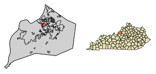
Cambridge is a home rule-class city in Jefferson County, Kentucky, United States. The population was 175 at the 2010 census.

<span class="mw-page-title-main">Druid Hills, Kentucky</span> City in Kentucky, United States

Druid Hills is a home rule-class city in Jefferson County, Kentucky, United States. The population was 308 at the 2010 census. It was incorporated in 1950.

<span class="mw-page-title-main">Hickory Hill, Kentucky</span> City in Kentucky, United States

Hickory Hill is a home rule-class city in Jefferson County, Kentucky, United States. The population was 114 at the 2010 census.

<span class="mw-page-title-main">Lincolnshire, Kentucky</span> City in Kentucky, United States

Lincolnshire is a home rule-class city in Jefferson County, Kentucky, United States. The population was 148 at the 2010 census.

<span class="mw-page-title-main">Meadowbrook Farm, Kentucky</span> City in Kentucky, United States

Meadowbrook Farm is a neighborhood of Louisville, Kentucky, United States. It is separately incorporated as a home rule-class city. The population was 136 as of the 2010 census.

<span class="mw-page-title-main">Parkway Village, Kentucky</span> City in Kentucky, United States

Parkway Village is a home rule-class city in Jefferson County, Kentucky, United States, and a part of the Louisville Metro government. It was developed in the 1920s and incorporated in 1941. The population was 650 at the 2010 census.

<span class="mw-page-title-main">Strathmoor Village, Kentucky</span> City in Kentucky, United States

Strathmoor Village is a home rule-class city in Jefferson County, Kentucky, United States. The population was 648 at the 2010 census.

<span class="mw-page-title-main">Sycamore, Kentucky</span> City in Kentucky, United States

Sycamore is a home rule-class city in Jefferson County, Kentucky, United States. The population was 160 at the 2010 census.

<span class="mw-page-title-main">Wellington, Kentucky</span> City in Kentucky, United States

Wellington is a home rule-class city in metro Louisville, Jefferson County, Kentucky, United States. It is considered to be part of the Upper Highlands section of Louisville. It was incorporated in 1946. The population was 565 at the 2010 census.

<span class="mw-page-title-main">Westwood, Jefferson County, Kentucky</span> City in Kentucky, United States

Westwood is a home rule-class city in Jefferson County, Kentucky, United States. The population was 634 at the 2010 census.

<span class="mw-page-title-main">Woodland Hills, Kentucky</span> City in Kentucky, United States

Woodland Hills is a home rule-class city in Jefferson County, Kentucky, United States. The population was 696 at the 2010 census.

<span class="mw-page-title-main">Louisville, Nebraska</span> City in Nebraska, United States

Louisville is a city in northern Cass County, Nebraska, United States. The population was 1,319 at the 2020 census.

<span class="mw-page-title-main">Addyston, Ohio</span> Village in Ohio, United States

Addyston is a village in Miami Township, Hamilton County, Ohio, United States. Located along the Ohio River, it is a western suburb of the neighboring city of Cincinnati. The population was 927 at the 2020 census.

<span class="mw-page-title-main">Verona, Ohio</span> Village in Ohio, United States

Verona is a village in Montgomery and Preble counties in the U.S. state of Ohio. The population was 403 at the 2020 census. It is part of the Dayton Metropolitan Statistical Area.

Morris is a village in Otsego County, New York, United States. The population was 583 at the 2010 census.

References

  1. "ArcGIS REST Services Directory". United States Census Bureau. Retrieved September 20, 2022.
  2. 1 2 3 U.S. Geological Survey Geographic Names Information System: St. Louisville, Ohio
  3. 1 2 "U.S. Census website". United States Census Bureau . Retrieved January 31, 2008.
  4. Overman, William Daniel (1958). Ohio Town Names. Akron, OH: Atlantic Press. p. 122.
  5. "US Gazetteer files 2010". United States Census Bureau. Archived from the original on January 25, 2012. Retrieved January 6, 2013.
  6. "Census of Population and Housing". Census.gov. Retrieved June 4, 2015.
  7. "U.S. Census website". United States Census Bureau . Retrieved January 6, 2013.