Airlake Airport is a public use airport in Dakota County, Minnesota, United States. Owned by the Metropolitan Airports Commission, It is approximately 20 miles (32 km) south of both downtown Minneapolis and downtown St. Paul The airport is located near the Twin Cities suburbs of Lakeville and Farmington.
Springdale Municipal Airport is a public use airport in Washington County, Arkansas, United States. It is owned by the City of Springdale and located one nautical mile (2 km) southeast of its central business district. This airport is included in the National Plan of Integrated Airport Systems for 2011–2015, which categorized it as a general aviation facility.

Zanesville Municipal Airport is a city-owned airport six miles east of downtown Zanesville, in Muskingum County, Ohio. The National Plan of Integrated Airport Systems for 2011–2015 called it a general aviation facility.
Baker City Municipal Airport is three miles north of Baker City, in Baker County, Oregon, United States. The National Plan of Integrated Airport Systems for 2011–2015 categorized it as a general aviation facility.
Delaware County Regional Airport is in Delaware County, Indiana three miles northwest of Muncie. Owned by the Delaware County Airport Authority, it was formerly Delaware County Airport and Johnson Field. The National Plan of Integrated Airport Systems for 2011–2015 categorized it as a general aviation facility.
North Little Rock Municipal Airport is a public use airport in Pulaski County, Arkansas, United States. It is owned by the City of North Little Rock and located four nautical miles north of its central business district.

Huntsville Executive Airport, also known as Tom Sharp Jr. Field and formerly Madison County Executive Airport, is a public-use airport in Madison County, Alabama, United States. It is owned by the Executive Flight Center and located eight nautical miles (14.80 km) northeast of the central business district of Huntsville. According to the FAA's National Plan of Integrated Airport Systems for 2009–2013, it is categorized as a general aviation facility.

Foley Municipal Airport is a city-owned public-use airport located three nautical miles northwest of the central business district of Foley, a city in Baldwin County, Alabama, United States.
Kingston–Ulster Airport is a privately owned, public use airport located four nautical miles north of the central business district of Kingston, a city in Ulster County, New York, United States. The airport is situated near East Kingston, in the Town of Ulster. This airport is included in the National Plan of Integrated Airport Systems for 2011–2015, which categorized it as a general aviation airport.

Dodge County Airport is a county-owned public-use airport in Dodge County, Wisconsin, United States. It is located two nautical miles (4 km) north of the central business district of Juneau, Wisconsin. It is situated along Wisconsin Highway 26.
Fostoria Metropolitan Airport is a city-owned public airport two miles northeast of Fostoria, Ohio, United States. The FAA's National Plan of Integrated Airport Systems for 2009-2013 classified it as a general aviation airport.

Laurel Municipal Airport is two miles north of Laurel, in Yellowstone County, Montana, and eleven miles (18 km) southwest of Billings, Montana, United States. The National Plan of Integrated Airport Systems for 2011–2015 categorized it as a general aviation facility. It sees no airlines.
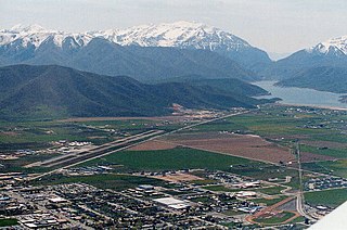
Heber City Municipal Airport, also known as Russ McDonald Field, is a city-owned, public-use airport located 1 mi (2 km) south of Heber City, in Wasatch County, Utah, United States, east of Salt Lake City. The airport is untowered and was activated in November 1947. It is included in the National Plan of Integrated Airport Systems for 2011–2015, which categorized it as a general aviation facility.
Midland Airpark is a public airport three miles north of Midland, in Midland County, Texas. The FAA's National Plan of Integrated Airport Systems for 2009–2013 categorized it as a general aviation facility.
Rogers Executive Airport, also known as Carter Field, is a city-owned public-use airport located two nautical miles (3.7 km) north of the central business district of Rogers, a city in Benton County, Arkansas, United States. This airport is included in the FAA's National Plan of Integrated Airport Systems for 2021–2025, which categorized it as a general aviation facility.
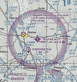
Bolivar Municipal Airport is a city-owned public-use airport located four nautical miles east of the central business district of Bolivar, a city in Polk County, Missouri, United States. It is included in the FAA's National Plan of Integrated Airport Systems for 2011–2015, which categorized it as a general aviation facility.
Webster City Municipal Airport is a city-owned public-use airport located three nautical miles (6 km) southwest of the central business district of Webster City, in Hamilton County, Iowa, United States. It is included in the National Plan of Integrated Airport Systems for 2015–2019, which categorized it as a general aviation facility.
Lakeview Airport, also known as Griffith Field, is a public use airport in Montcalm County, Michigan, United States. It is owned by the village of Lakeview and located one nautical mile (2 km) northeast of its central business district. It is included in the Federal Aviation Administration (FAA) National Plan of Integrated Airport Systems for 2017–2021, in which it is categorized as a local general aviation facility.
Ravalli County Airport is a public use airport in Ravalli County, Montana, United States. It is owned by Ravalli County and located one nautical mile (2 km) east of the central business district of Hamilton, Montana. This airport is included in the National Plan of Integrated Airport Systems for 2011–2015, which categorized it as a general aviation facility.
Three Forks Airport is a public use airport in Gallatin County, Montana, United States. The airport is owned by Gallatin County and located one nautical mile (2 km) southeast of the central business district of Three Forks, Montana. It is also known as Pogreba Field, named for a World War II, Korean War and Vietnam War combat aviator from Three Forks. This airport is included in the National Plan of Integrated Airport Systems for 2011–2015, which categorized it as a general aviation facility.


