Related Research Articles
Wyandot County is a county located in the northwestern part of the U.S. state of Ohio. As of the 2020 census, the population was 21,900. Its county seat is Upper Sandusky. It was named for the Wyandot Indians, who lived here before and after European encounter. Their autonym is variously translated from their language as "around the plains" and "dwellers on the peninsula".

Sycamore is a village in Wyandot County, Ohio, United States. The population was 861 at the 2010 census.

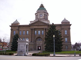
Upper Sandusky is a city and the county seat of Wyandot County, Ohio, United States, along the upper Sandusky River, which flows north to Sandusky Bay and Lake Erie. The city is approximately 59 mi (96 km) south of Toledo and 62 mi (99 km) north of Columbus. The population was 6,596 at the 2010 census. The city was founded in 1843 and named for an earlier Wyandot Indian village of the same name, which was located nearby. It was named "Upper" because it is located near the headwaters of the Sandusky River.
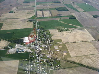
Wharton is a village in Wyandot County, Ohio, United States. The population was 358 at the 2010 census.

Ohio's 4th congressional district spans sections of the northeast, central, and southwest areas of the state. Its nickname, "the duck district," refers to its gerrymandered geographical shape being similar to a duck. The district zig-zags west and south from Cleveland's suburbs to Mercer County on the Indiana border. The largest city in the district is Elyria. It also includes Oberlin, home of Oberlin College. It is currently represented by Republican Jim Jordan, who has represented the district since 2007.

Roundhead is an unincorporated community in southeastern Roundhead Township, Hardin County, Ohio, United States. It has a post office with the ZIP code 43346.

Mexico is an unincorporated community in northeastern Tymochtee Township, Wyandot County, Ohio, United States. Located at 40°59′11″N83°11′36″W, it lies at an elevation of 810 feet.
Tymochtee is an unincorporated community in Wyandot County, in the U.S. state of Ohio.
Little Sandusky is an unincorporated community in Wyandot County, in the U.S. state of Ohio.
Belle Vernon is an unincorporated community in Wyandot County, in the U.S. state of Ohio.
Brownstown is an unincorporated community in Wyandot County in the U.S. state of Ohio.
Crawford is an unincorporated community in Wyandot County, in the U.S. state of Ohio.
Deunquat is an unincorporated community in Wyandot County, in the U.S. state of Ohio.
Lovell is an unincorporated community in Wyandot County, in the U.S. state of Ohio.
Wyandot is an unincorporated community in Wyandot County, in the U.S. state of Ohio.
White Oak is an unincorporated community in Brown County, in the U.S. state of Ohio.
Yondota is an unincorporated community in Lucas County, in the U.S. state of Ohio.
Stratford is an unincorporated community in Delaware County, in the U.S. state of Ohio.
Indian Run is a stream located entirely within Delaware County, Ohio.
Brush Ridge is an unincorporated community in Grand Prairie Township, Marion County, Ohio, United States.
References
- ↑ U.S. Geological Survey Geographic Names Information System: Seal, Ohio
- ↑ The History of Wyandot County, Ohio: Containing a History of the County; Its Townships, Towns, Churches, Schools, Etc. Leggett, Conaway & Company. 1884. p. 432.
- ↑ "Wyandot County". Jim Forte Postal History. Retrieved 7 December 2015.
Municipalities and communities of Wyandot County, Ohio, United States | ||
|---|---|---|
| City |  | |
| Villages | ||
| Townships | ||
| CDP | ||
| Unincorporated communities | ||
| Footnotes | ‡This populated place also has portions in an adjacent county or counties. | |
Coordinates: 40°52′37″N83°09′02″W / 40.87694°N 83.15056°W
| | This Wyandot County, Ohio state location article is a stub. You can help Wikipedia by expanding it. |