Wyandot County is a county located in the northwestern part of the U.S. state of Ohio. As of the 2020 census, the population was 21,900. Its county seat is Upper Sandusky. It was named for the Wyandot Indians, who lived here before and after European encounter. Their autonym is variously translated from their language as "around the plains" and "dwellers on the peninsula".

Crawford County is a county located in the north central portion of the U.S. state of Ohio. As of the 2020 census, the population was 42,025. Its county seat and largest city is Bucyrus. The county was created in 1820 and later organized in 1836. It was named for Colonel William Crawford, a soldier during the American Revolution.

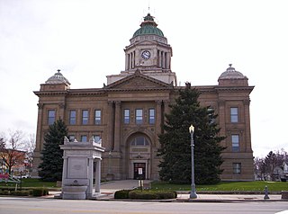
Upper Sandusky is a city in and the county seat of Wyandot County, Ohio, United States, along the upper Sandusky River. The city lies approximately 59 miles (95 km) south of Toledo and 62 miles (100 km) north of Columbus. The population was 6,698 at the 2020 census.

The Sandusky River is a tributary to Lake Erie in north-central Ohio in the United States. It is about 133 miles (214 km) long and flows into Lake Erie at the southwest side of Sandusky Bay.

Big Spring Township is one of the fifteen townships of Seneca County, Ohio, United States. The 2020 census found 1,683 people in the township.

Texas Township is one of the sixteen townships of Crawford County, Ohio, United States. As of the 2020 census the population was 352.

Tod Township is one of the sixteen townships of Crawford County, Ohio, United States. As of the 2020 census the population was 627.

The Crawford expedition, also known as the Sandusky expedition and Crawford's Defeat, was a 1782 campaign on the western front of the American Revolutionary War, and one of the final operations of the conflict. The campaign was led by Colonel William Crawford, a former officer in the U.S. Continental Army. Crawford's goal was to destroy enemy Native American towns along the Sandusky River in the Ohio Country, with the hope of ending Native attacks on American settlers. The expedition was one in a series of raids against enemy settlements that both sides had conducted throughout the war.

Roundhead is an unincorporated community in southeastern Roundhead Township, Hardin County, Ohio, United States. It has a post office with the ZIP code 43346.

McCutchenville is a census-designated place (CDP) in northern Wyandot and southern Seneca counties, Ohio, United States. It has a post office with the ZIP code 44844. It lies at the intersection of State Routes 53 and 587. The population was 371 at the 2020 census.

Brokensword is an unincorporated community on the border between the Holmes and Lykens townships of Crawford County, Ohio, United States. Located at the intersection of the concurrent State Routes 19 and 100 with Brokensword Road, it is six miles north and two miles west of the city of Bucyrus, the county seat. Broken Sword Creek flows a short distance to the south of the community.
Tymochtee is an unincorporated community in Wyandot County, in the U.S. state of Ohio.
Little Sandusky is an unincorporated community in Wyandot County, in the U.S. state of Ohio.
Belle Vernon is an unincorporated community in Wyandot County, in the U.S. state of Ohio.
Crawford is an unincorporated community in Wyandot County, in the U.S. state of Ohio.
Deunquat is an unincorporated community in Wyandot County, in the U.S. state of Ohio. The community is 3 miles from Sycamore and 2 miles from Benton, and is accessed by C-34 and OH-231.
Lovell is an unincorporated community in Wyandot County, in the U.S. state of Ohio.
Seal is an unincorporated community in Wyandot County, in the U.S. state of Ohio.
Wyandot is an unincorporated community in Wyandot County, in the U.S. state of Ohio.
Yondota is an unincorporated community in Lucas County, in the U.S. state of Ohio.

