
The Big Rocky Fork Covered Bridge is located 1 mile (1.6 km) southeast of Mansfield, Indiana, on County Road 720 and about 2 miles (3.2 km) east of State Road 59, in Parke County.

The Beeson Covered Bridge originally crossed Roaring Creek, one mile (1.6 km) northwest of Marshall, Indiana, on County Road 216, in Washington Township, Parke County. The bridge was moved to its current location in Billie Creek Village in December 1979.

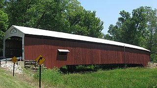
The McAllister Covered Bridge is a Burr Arch structure that was built by Joseph A. Britton and Son in 1914. It is 144 feet (44 m) long, 16 feet (4.9 m) wide, and 14 feet (4.3 m) high. It is found in Adams Township, Parke County, Indiana, United States.

The Mecca Covered Bridge crossing Big Raccoon Creek East of Mecca, Indiana is a single span Burr Arch Truss covered bridge structure that was built by J. J. Daniels in 1873. The bridge is 176 feet (54 m) long, 17 feet (5.2 m) wide, and 12.5 feet (3.8 m) high.

The Melcher Covered Bridge, also known as the "Klondyke Covered Bridge", "Marion Covered Bridge", or the "Leatherwood Covered Bridge" crosses Leatherwood Creek east of Montezuma, Indiana, and is a single-span Burr Arch Truss covered bridge structure that was built by Joseph J. Daniels in 1896.
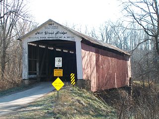
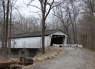
The Mill Creek Covered Bridge also known as "Thompson's Ford Covered Bridge," "Tow Path Covered Bridge," or "Earl Ray Covered Bridge" crosses Wabash Mill Creek (historic) southwest of Tangier, Indiana. It is a single span Burr Arch Truss covered bridge structure that was built by D. M. Brown in 1907.

The Rush Creek Covered Bridge is south of Tangier, Indiana. The single span Burr Arch covered bridge structure was built by William Hendricks in 1904.

The Sim Smith Covered Bridge is east of Montezuma, Indiana. The single span Burr Truss covered bridge structure was built by Joseph A. Britton in 1883. The bridge is 101 feet (31 m) long, 16 feet (4.9 m) wide, and 14 feet (4.3 m) high.

The Wilkins Mill Covered Bridge is north of Rockville, Indiana. The single span Burr Arch Truss covered bridge structure was built by William Hendricks in 1906. The bridge is 120 feet (37 m) long, 16 feet (4.9 m) wide, and 13 feet (4.0 m) high.

Forsythe Covered Bridge, also known as Forsythe Mill Bridge, is a historic covered bridge located near Rushville, Indiana and/or Gowdy, in Orange Township, Rush County, Indiana. It was built in 1888 by Emmett L. Kennedy. It is a Burr Arch bridge, 196 feet (60 m) long over the Big Flat Rock River. The bridge has rounded arch portals and decorative scrollwork that are signatures of the Kennedy firm.
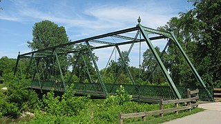
Twin Bridges are two historic bridges located at Danville, Hendricks County, Indiana. The Hendricks County Bridge #178 is a Baltimore through Truss bridge built in 1887. The wrought iron bridge measures 149 feet, 6 inches, long and spans White Lick Creek. The Big Four Railroad Bridge was built by the Big Four Railroad and built in 1906. It is a three-span concrete structure and spans White Lick Creek and County Road 150 East. Associated with the bridges is a cut stone railroad abutment built about 1870.
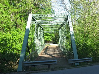
Hendricks County Bridge Number 316, also known as Friendship Gardens Bridge, is a historic Pinned Warren Truss bridge located at Plainfield, Hendricks County, Indiana. It was built in 1886, by the Morse Bridge Company of Youngstown, Ohio. The single span bridge measures 170 feet long and spans White Lick Creek.

Paw Paw Creek Bridge No. 52 was a historic Bow-String arch bridge located in Richland Township, Miami County, Indiana. It was built in 1874 by the Wrought Iron Bridge Company and spanned Paw Paw Creek. It was a single-span wrought iron structure with an overall length of 111 feet and width of 21 feet.. The bridge was disassembled after a tree fell on it.
Darlington Covered Bridge is a historic covered bridge located in Franklin Township, Montgomery County, Indiana. It was built in 1868, and is a single span, Howe truss covered bridge that spans Sugar Creek. It measures 166 feet long and has an overall width of 22 feet.

Norris Ford Covered Bridge is a historic covered bridge located near Rushville, Indiana in Rushville Township, Rush County, Indiana. It was built in 1916 by Emmett L. Kennedy and his sons Karl and Charles. It is a Burr Arch bridge, 154 feet (47 m) long over Big Flat Rock Creek. The bridge has rounded arch portals and does not have the decorative scrollwork and brackets that are signatures of the Kennedy firm, due to them being out of vogue by 1916.

Offutt Covered Bridge is a historic covered bridge located near Rushville, Indiana in Jackson Township, Rush County, Indiana. It was built in 1877 by A.M. Kennedy and his son Emmett. It is a Burr Arch bridge, 124 feet (38 m) long over Big Flat Rock Creek. The bridge has rounded arch portals and decorative scrollwork that are signatures of the Kennedy firm.

Brownsville Covered Bridge was a historic long truss covered bridge located at Brownsville, Union County, Indiana. It was built between 1837 and 1840, and was a single span covered timber bridge. It measured 182 feet (55 m) long and 21 feet 6 inches (6.55 m) wide. The bridge spanned the East Fork of the Whitewater River.

Eugene Covered Bridge, also known as County Bridge No. 75, is a historic Burr Arch Truss covered bridge located in Eugene Township, Vermillion County, Indiana. It was built in 1873, and is a single span covered timber bridge. It measures 180 feet long and 16 feet wide. The bridge spans the Big Vermilion River.
Newport Covered Bridge, also known as the Morehead Covered Bridge and County Bridge No. 67, is a historic Burr Arch Truss covered bridge located in Vermillion Township, Vermillion County, Indiana. It was built in 1885, and is a single span covered timber bridge. It measures 210 feet long and 16 feet wide. The bridge spans the Little Vermilion River.

Possum Bottom Covered Bridge, also known as the Jackson's Ford Bridge and Hillsdale Bridge, is a historic Burr Arch Truss covered bridge located in Helt Township, Vermillion County, Indiana. It was built in 1876, and is a single span covered timber bridge. It measures 131 feet long and 14 feet wide. It was moved to its present location at the Ernie Pyle Rest Park in 1972.


