National Register of Historic Places listings in Ripley County, Indiana

Last updated

Location of Ripley County in Indiana Map of Indiana highlighting Ripley County.svg
Location of Ripley County in Indiana

This is a list of the National Register of Historic Places listings in Ripley County, Indiana.

Contents

This is intended to be a complete list of the properties on the National Register of Historic Places in Ripley County, Indiana, United States. Latitude and longitude coordinates are provided for many National Register properties; these locations may be seen together in a map. [1]

There are 16 properties listed on the National Register in the county.

Properties and districts located in incorporated areas display the name of the municipality, while properties and districts in unincorporated areas display the name of their civil township. Properties and districts split between multiple jurisdictions display the names of all jurisdictions.


    This National Park Service list is complete through NPS recent listings posted May 12, 2023. [2]

Map all coordinates using: OpenStreetMap  
Download coordinates as: KML

Current listings

[3] Name on the Register [4] ImageDate listed [5] Location City or townDescription
1 Busching Covered Bridge
Busching Covered Bridge 036 34A Busching, Versailles SP, Versailles Cty.jpg
Busching Covered Bridge
March 13, 2019
(#100003509)
E. Perry St./E Cty. Rd. 25 S at Laughery Cr.
39°04′04″N85°14′16″W / 39.0678°N 85.2378°W / 39.0678; -85.2378 (Busching Covered Bridge)
Versailles vicinity1885 Howe truss bridge, located Versailles State Park.
2 Central Batesville Historic District
Central Batesville Historic District George west of Walnut in Batesville.jpg
Central Batesville Historic District
September 15, 2011
(#11000659)
Roughly bounded by Catherine, Vine, and Boehringer Sts., and Eastern Ave.
39°17′52″N85°13′19″W / 39.297778°N 85.221944°W / 39.297778; -85.221944 (Central Batesville Historic District)
Batesville
3 Central House
Central House Central House in Napoleon.jpg
Central House
September 23, 1982
(#82000071)
State Road 229
39°12′18″N85°19′42″W / 39.205056°N 85.328333°W / 39.205056; -85.328333 (Central House)
Napoleon
4 Collin's Ford Bridge
Collin's Ford Bridge Collin's Ford Bridge.jpg
Collin's Ford Bridge
July 30, 1996
(#96000787)
Big Oaks National Wildlife Refuge, approximately 0.75 miles west of New Marion
39°00′29″N85°22′14″W / 39.008056°N 85.370556°W / 39.008056; -85.370556 (Collin's Ford Bridge)
Shelby Township
5 Elias Conwell House
Elias Conwell House Elias Conwell House.jpg
Elias Conwell House
May 14, 1979
(#79000041)
Wilson St. and U.S. Route 421
39°12′23″N85°19′50″W / 39.206389°N 85.330556°W / 39.206389; -85.330556 (Elias Conwell House)
Napoleon
6 Friendship Stone Arch Bridge
Friendship Stone Arch Bridge Friendship Stone Arch Bridge.jpg
Friendship Stone Arch Bridge
March 11, 2019
(#100003510)
Olean Rd./Cty Rd. 525 E over Raccoon Cr.
38°58′26″N85°09′33″W / 38.9740°N 85.1591°W / 38.9740; -85.1591 (Friendship Stone Arch Bridge)
Friendship vicinity
7 Marble Creek Bridge
Marble Creek Bridge Marble Creek Bridge.jpg
Marble Creek Bridge
July 30, 1996
(#96000785)
Big Oaks National Wildlife Refuge, approximately 0.75 miles west of the junction of G and W. Recovery Rds.
38°55′39″N85°26′31″W / 38.9275°N 85.441944°W / 38.9275; -85.441944 (Marble Creek Bridge)
Shelby Township
8 Milan Masonic Lodge No. 31
Milan Masonic Lodge No. 31 Milan Masonic Lodge No. 31.jpg
Milan Masonic Lodge No. 31
January 9, 2013
(#12001155)
312 Main St.
39°07′30″N85°07′54″W / 39.125000°N 85.131667°W / 39.125000; -85.131667 (Milan Masonic Lodge No. 31)
Milan
9 Old Timbers
Old Timbers Old Timbers Exterior.jpg
Old Timbers
July 30, 1996
(#96000786)
Big Oaks National Wildlife Refuge, approximately 0.5 miles southeast of the junction of K Rd. and Northeast Exit
39°00′17″N85°23′26″W / 39.004722°N 85.390556°W / 39.004722; -85.390556 (Old Timbers)
Shelby Township
10 Otter Creek Covered Bridge
Otter Creek Covered Bridge Otter Creek Covered Bridge.jpg
Otter Creek Covered Bridge
March 13, 2019
(#100003511)
N. Cty. Rd. 850 W at Otter Cr.
39°05′07″N85°24′37″W / 39.0853°N 85.4102°W / 39.0853; -85.4102 (Otter Creek Covered Bridge)
Holton vicinity
11 John Linsey Rand House
John Linsey Rand House John Linsey Rand House.jpg
John Linsey Rand House
June 10, 1994
(#94000582)
Southwestern corner of the junction of State Road 62 and Maxine Moss Dr. at Friendship
38°57′57″N85°08′43″W / 38.965833°N 85.145278°W / 38.965833; -85.145278 (John Linsey Rand House)
Brown Township
12 Ripley County Courthouse
Ripley County Courthouse Ripley County Courthouse, Versailles, IN (48467486191).jpg
Ripley County Courthouse
September 24, 2009
(#09000762)
115 N. Main St.
39°04′19″N85°15′07″W / 39.071944°N 85.251944°W / 39.071944; -85.251944 (Ripley County Courthouse)
Versailles
13 Straber Ford Bridge
Straber Ford Bridge Straber Ford Bridge.jpg
Straber Ford Bridge
December 24, 2009
(#09001132)
County Road 500N over Otter Creek, northwest of Osgood
39°08′53″N85°21′44″W / 39.147944°N 85.362222°W / 39.147944; -85.362222 (Straber Ford Bridge)
Center Township
14 Fernando G. Taylor House
Fernando G. Taylor House Fernando G. Taylor House, Versailles, IN (48467642797).jpg
Fernando G. Taylor House
September 22, 1986
(#86002710)
Northeastern corner of Main and Tyson Sts.
39°04′17″N85°15′03″W / 39.071389°N 85.250833°W / 39.071389; -85.250833 (Fernando G. Taylor House)
Versailles
15 Tyson United Methodist Church
Tyson United Methodist Church Tyson United Methodist Church, Versailles, IN (48467518931).jpg
Tyson United Methodist Church
September 8, 1994
(#94001106)
324 W. Tyson St.
39°04′19″N85°15′14″W / 39.071944°N 85.253889°W / 39.071944; -85.253889 (Tyson United Methodist Church)
Versailles
16 Versailles School and Tyson Auditorium
Versailles School and Tyson Auditorium Old Tyson School, Versailles, IN (48467508236).jpg
Versailles School and Tyson Auditorium
April 19, 2006
(#06000309)
100 S. High St.
39°04′18″N85°15′20″W / 39.071667°N 85.255556°W / 39.071667; -85.255556 (Versailles School and Tyson Auditorium)
Versailles

See also

Related Research Articles

<span class="mw-page-title-main">National Register of Historic Places listings in Wayne County, Indiana</span>

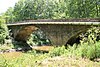
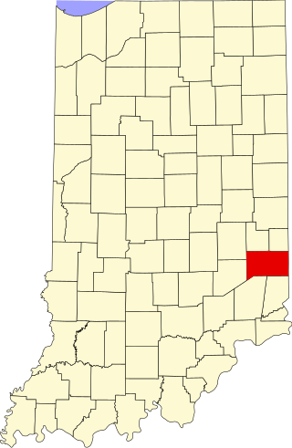
This is a list of the National Register of Historic Places listings in Wayne County, Indiana.

<span class="mw-page-title-main">National Register of Historic Places listings in Dearborn County, Indiana</span>

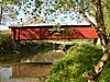
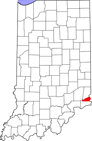
This is a list of the National Register of Historic Places listings in Dearborn County, Indiana.

<span class="mw-page-title-main">National Register of Historic Places listings in DeKalb County, Indiana</span>

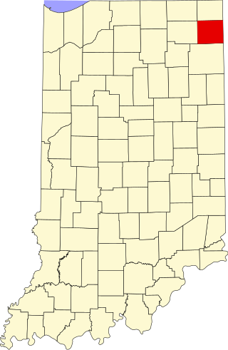
This is a list of the National Register of Historic Places listings in DeKalb County, Indiana.

<span class="mw-page-title-main">National Register of Historic Places listings in Bartholomew County, Indiana</span>

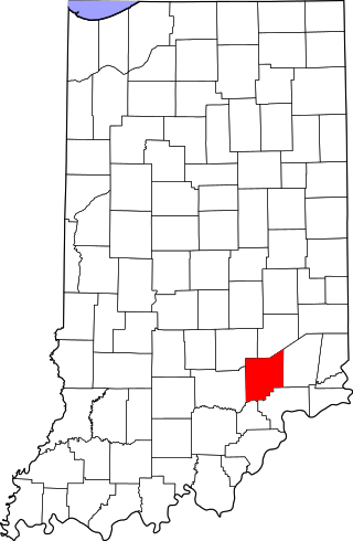
This is a list of the National Register of Historic Places listings in Bartholomew County, Indiana.

<span class="mw-page-title-main">National Register of Historic Places listings in Adams County, Indiana</span>

This is a list of the National Register of Historic Places listings in Adams County, Indiana.

<span class="mw-page-title-main">National Register of Historic Places listings in Blackford County, Indiana</span>

This is a list of the National Register of Historic Places listings in Blackford County, Indiana.

<span class="mw-page-title-main">National Register of Historic Places listings in Cass County, Indiana</span>

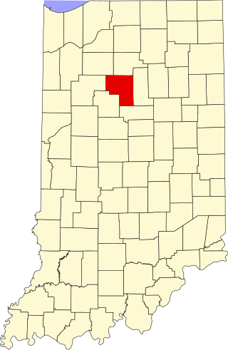
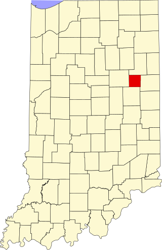
This is a list of the National Register of Historic Places listings in Cass County, Indiana.

<span class="mw-page-title-main">National Register of Historic Places listings in Whitley County, Indiana</span>

This is a list of the National Register of Historic Places listings in Whitley County, Indiana.

<span class="mw-page-title-main">National Register of Historic Places listings in Decatur County, Indiana</span>

This is a list of the National Register of Historic Places listings in Decatur County, Indiana.

<span class="mw-page-title-main">National Register of Historic Places listings in Dubois County, Indiana</span>

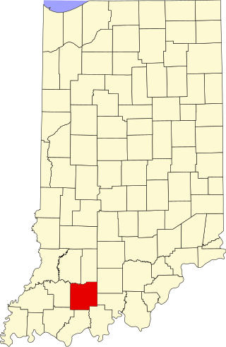
This is a list of the National Register of Historic Places listings in Dubois County, Indiana.

<span class="mw-page-title-main">National Register of Historic Places listings in Fountain County, Indiana</span>

This is a list of the National Register of Historic Places listings in Fountain County, Indiana.

<span class="mw-page-title-main">National Register of Historic Places listings in Franklin County, Indiana</span>

This is a list of the National Register of Historic Places listings in Franklin County, Indiana.

<span class="mw-page-title-main">National Register of Historic Places listings in Hendricks County, Indiana</span>

This is a list of the National Register of Historic Places listings in Hendricks County, Indiana.

<span class="mw-page-title-main">National Register of Historic Places listings in Jefferson County, Indiana</span>

This is a list of the National Register of Historic Places listings in Jefferson County, Indiana.

<span class="mw-page-title-main">National Register of Historic Places listings in Jennings County, Indiana</span>

This is a list of the National Register of Historic Places listings in Jennings County, Indiana.

<span class="mw-page-title-main">National Register of Historic Places listings in Newton County, Indiana</span>

This is a list of the National Register of Historic Places listings in Newton County, Indiana.

<span class="mw-page-title-main">National Register of Historic Places listings in Orange County, Indiana</span>

This is a list of the National Register of Historic Places listings in Orange County, Indiana.

<span class="mw-page-title-main">National Register of Historic Places listings in Switzerland County, Indiana</span>

This is a list of the National Register of Historic Places listings in Switzerland County, Indiana.

<span class="mw-page-title-main">National Register of Historic Places listings in Ohio County, Indiana</span>

This is a list of the National Register of Historic Places listings in Ohio County, Indiana.

<span class="mw-page-title-main">National Register of Historic Places listings in Kosciusko County, Indiana</span>

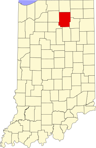
This is a list of the National Register of Historic Places listings in Kosciusko County, Indiana.

References

  1. The latitude and longitude information provided in this table was derived originally from the National Register Information System, which has been found to be fairly accurate for about 99% of listings. Some locations in this table may have been corrected to current GPS standards.
  2. National Park Service, United States Department of the Interior, "National Register of Historic Places: Weekly List Actions", retrieved May 12, 2023.
  3. Numbers represent an alphabetical ordering by significant words. Various colorings, defined here, differentiate National Historic Landmarks and historic districts from other NRHP buildings, structures, sites or objects.
  4. "National Register Information System". National Register of Historic Places . National Park Service. March 13, 2009.
  5. The eight-digit number below each date is the number assigned to each location in the National Register Information System database, which can be viewed by clicking the number.