National Register of Historic Places listings in Dubois County, Indiana

Last updated

Location of Dubois County in Indiana Map of Indiana highlighting Dubois County.svg
Location of Dubois County in Indiana

This is a list of the National Register of Historic Places listings in Dubois County, Indiana.

Contents

This is intended to be a complete list of the properties and districts on the National Register of Historic Places in Dubois County, Indiana, United States. Latitude and longitude coordinates are provided for many National Register properties and districts; these locations may be seen together in a map. [1]

There are 16 properties and districts listed on the National Register in the county.

Properties and districts located in incorporated areas display the name of the municipality, while properties and districts in unincorporated areas display the name of their civil township. Properties and districts split between multiple jurisdictions display the names of all jurisdictions.


    This National Park Service list is complete through NPS recent listings posted December 8, 2023. [2]

Map all coordinates using: OpenStreetMap

Current listings

[3] Name on the Register [4] ImageDate listed [5] Location City or townDescription
1 Convent Immaculate Conception Historic District
Convent Immaculate Conception Historic District Monastery of Immaculate Conception closeup.JPG
Convent Immaculate Conception Historic District
July 13, 1983
(#83000122)
802 E. 10th St.
38°13′23″N86°51′08″W / 38.2231°N 86.8522°W / 38.2231; -86.8522 (Convent Immaculate Conception Historic District)
Ferdinand
2 Dubois County Courthouse
Dubois County Courthouse Dubois County Courthouse in Jasper from southeast.jpg
Dubois County Courthouse
January 11, 1996
(#95001538)
One Courthouse Square
38°23′29″N86°55′52″W / 38.3914°N 86.9311°W / 38.3914; -86.9311 (Dubois County Courthouse)
Jasper
3 Evangelische Lutherische Emanuels Kirche
Evangelische Lutherische Emanuels Kirche Evangelische Lutherische Emanuels Kirche, front from slight north.jpg
Evangelische Lutherische Emanuels Kirche
February 23, 1990
(#90000329)
County Road 445E, 1 mile south of State Road 56 and northwest of Dubois
38°27′59″N86°49′23″W / 38.4664°N 86.8231°W / 38.4664; -86.8231 (Evangelische Lutherische Emanuels Kirche)
Harbison Township
4 Gramelspacher-Gutzweiler House
Gramelspacher-Gutzweiler House Gramelspacher-Gutzweiler House.jpg
Gramelspacher-Gutzweiler House
February 26, 1983
(#83000027)
11th and Main Sts.
38°23′42″N86°55′52″W / 38.395°N 86.9311°W / 38.395; -86.9311 (Gramelspacher-Gutzweiler House)
Jasper
5 Huntingburg Commercial Historic District
Huntingburg Commercial Historic District Huntingburg Commercial Historic District.jpg
Huntingburg Commercial Historic District
June 21, 2006
(#06000517)
Roughly bounded by Geiger, 4th, Jackson, and Market Sts.
38°17′44″N86°57′19″W / 38.2956°N 86.9553°W / 38.2956; -86.9553 (Huntingburg Commercial Historic District)
Huntingburg
6 Huntingburg Town Hall and Fire Engine House
Huntingburg Town Hall and Fire Engine House Huntingburg Town Hall and Fire Engine House.jpg
Huntingburg Town Hall and Fire Engine House
May 12, 1975
(#75000016)
311 Geiger St.
38°17′42″N86°57′25″W / 38.295°N 86.9569°W / 38.295; -86.9569 (Huntingburg Town Hall and Fire Engine House)
Huntingburg
7 Jasper Downtown Historic District
Jasper Downtown Historic District Jasper indiana square.jpg
Jasper Downtown Historic District
June 12, 2017
(#100001058)
Roughly bounded by 9th, Clay, 3rd, and Mill Sts.
38°23′29″N86°55′51″W / 38.3914°N 86.9308°W / 38.3914; -86.9308 (Jasper Downtown Historic District)
Jasper
8 Lemmon's Church and Cemetery
Lemmon's Church and Cemetery Lemmon Presbyterian Church from the southeast.jpg
Lemmon's Church and Cemetery
June 4, 1992
(#92000674)
Portersville Rd. east of its junction with County Road 750W, west of Portersville
38°29′28″N87°02′29″W / 38.4911°N 87.0414°W / 38.4911; -87.0414 (Lemmon's Church and Cemetery)
Boone Township
9 Maple Grove Campground August 24, 2021
(#100006845)
6685 Cty. Rd. 585 West
38°16′53″N87°00′45″W / 38.2815°N 87.0125°W / 38.2815; -87.0125 (Maple Grove Campground)
Huntingburg vicinity
10 John Opel House
John Opel House John Opel House.jpg
John Opel House
October 4, 1984
(#84000009)
St. James St.
38°22′09″N86°54′23″W / 38.3692°N 86.9064°W / 38.3692; -86.9064 (John Opel House)
Jasper
11 St. Ferdinand Parish Historic District
St. Ferdinand Parish Historic District Tretter Center at St. Ferdinand Church.jpg
St. Ferdinand Parish Historic District
August 31, 2020
(#100005513)
Roughly bounded by Maryland, 8th, and 10th Sts. and St. Benedict Drive,
38°13′23″N86°51′38″W / 38.2231°N 86.8605°W / 38.2231; -86.8605 (St. Ferdinand Parish Historic District)
Ferdinand
12 St. Joseph Catholic Church
St. Joseph Catholic Church St. Joseph's Catholic Church in Jasper, vertical.jpg
St. Joseph Catholic Church
September 30, 1980
(#80000033)
1215 N. Newton St.
38°23′44″N86°55′56″W / 38.3956°N 86.9322°W / 38.3956; -86.9322 (St. Joseph Catholic Church)
Jasper
13 Shiloh Meeting House and Cemetery
Shiloh Meeting House and Cemetery Shiloh Presbyterian Church near Ireland from the northeast.jpg
Shiloh Meeting House and Cemetery
July 29, 1982
(#82000035)
Southeast of Ireland on 150 North Rd.
38°23′53″N86°58′57″W / 38.3981°N 86.9825°W / 38.3981; -86.9825 (Shiloh Meeting House and Cemetery)
Madison Township
14 Louis H. Sturm Hardware Store
Louis H. Sturm Hardware Store Louis H. Sturm Hardware Store.jpg
Louis H. Sturm Hardware Store
September 28, 2003
(#03000975)
516 Main St.
38°23′27″N86°55′49″W / 38.3908°N 86.9303°W / 38.3908; -86.9303 (Louis H. Sturm Hardware Store)
Jasper
15 Dr. Alois Wollenmann House
Dr. Alois Wollenmann House Dr. Alois Wollenmann House.jpg
Dr. Alois Wollenmann House
March 20, 2013
(#13000083)
1150 Main St.
38°13′31″N86°51′40″W / 38.2253°N 86.8611°W / 38.2253; -86.8611 (Dr. Alois Wollenmann House)
Ferdinand
16 Zoar Public School, Zoar Methodist Church, Zoar Cemetery December 11, 2023
(#100009589)
8818 West Old State Road 64 and Zoar Church Road
38°05′07″N87°26′26″W / 38.0854°N 87.4406°W / 38.0854; -87.4406 (Zoar Public School, Zoar Methodist Church, Zoar Cemetery)
Zoar

See also

Related Research Articles

<span class="mw-page-title-main">National Register of Historic Places listings in Wayne County, Indiana</span>

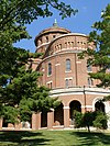
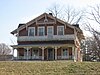
This is a list of the National Register of Historic Places listings in Wayne County, Indiana.

<span class="mw-page-title-main">National Register of Historic Places listings in Bartholomew County, Indiana</span>

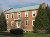
This is a list of the National Register of Historic Places listings in Bartholomew County, Indiana.

<span class="mw-page-title-main">National Register of Historic Places listings in Adams County, Indiana</span>

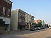
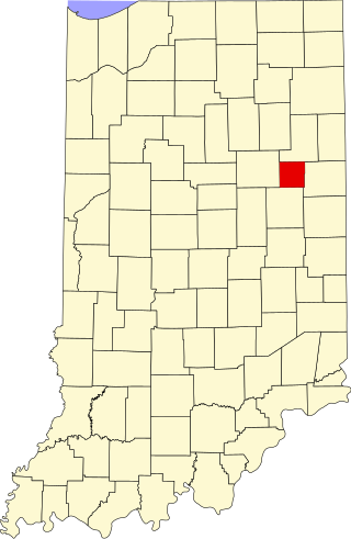
This is a list of the National Register of Historic Places listings in Adams County, Indiana.

<span class="mw-page-title-main">National Register of Historic Places listings in Blackford County, Indiana</span>

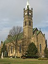
This is a list of the National Register of Historic Places listings in Blackford County, Indiana.

<span class="mw-page-title-main">National Register of Historic Places listings in Daviess County, Indiana</span>

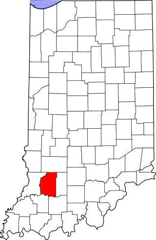
This is a list of the National Register of Historic Places listings in Daviess County, Indiana.

<span class="mw-page-title-main">National Register of Historic Places listings in Decatur County, Indiana</span>

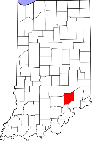
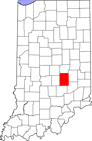
This is a list of the National Register of Historic Places listings in Decatur County, Indiana.

<span class="mw-page-title-main">National Register of Historic Places listings in Fountain County, Indiana</span>

This is a list of the National Register of Historic Places listings in Fountain County, Indiana.

<span class="mw-page-title-main">National Register of Historic Places listings in Hendricks County, Indiana</span>

This is a list of the National Register of Historic Places listings in Hendricks County, Indiana.

<span class="mw-page-title-main">National Register of Historic Places listings in Jennings County, Indiana</span>

This is a list of the National Register of Historic Places listings in Jennings County, Indiana.

<span class="mw-page-title-main">National Register of Historic Places listings in Orange County, Indiana</span>

This is a list of the National Register of Historic Places listings in Orange County, Indiana.

<span class="mw-page-title-main">National Register of Historic Places listings in Perry County, Indiana</span>

This is a list of the National Register of Historic Places listings in Perry County, Indiana.

<span class="mw-page-title-main">National Register of Historic Places listings in Pike County, Indiana</span>

This is a list of the National Register of Historic Places listings in Pike County, Indiana.

<span class="mw-page-title-main">National Register of Historic Places listings in Pulaski County, Indiana</span>

This is a list of the National Register of Historic Places listings in Pulaski County, Indiana.

<span class="mw-page-title-main">National Register of Historic Places listings in Ripley County, Indiana</span>

This is a list of the National Register of Historic Places listings in Ripley County, Indiana.

<span class="mw-page-title-main">National Register of Historic Places listings in Shelby County, Indiana</span>

This is a list of the National Register of Historic Places listings in Shelby County, Indiana.

<span class="mw-page-title-main">National Register of Historic Places listings in Spencer County, Indiana</span>

This is a list of the National Register of Historic Places listings in Spencer County, Indiana.

<span class="mw-page-title-main">National Register of Historic Places listings in Warren County, Indiana</span>

This is a list of the National Register of Historic Places listings in Warren County, Indiana.

<span class="mw-page-title-main">National Register of Historic Places listings in Warrick County, Indiana</span>

This is a list of the National Register of Historic Places listings in Warrick County, Indiana.

<span class="mw-page-title-main">National Register of Historic Places listings in Crawford County, Indiana</span>

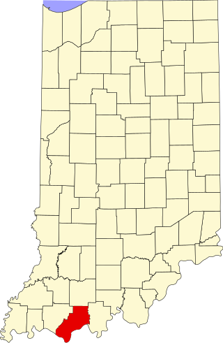
This is a list of the National Register of Historic Places listings in Crawford County, Indiana.

<span class="mw-page-title-main">National Register of Historic Places listings in Kosciusko County, Indiana</span>

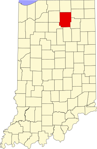
This is a list of the National Register of Historic Places listings in Kosciusko County, Indiana.

References

  1. The latitude and longitude information provided in this table was derived originally from the National Register Information System, which has been found to be fairly accurate for about 99% of listings. Some locations in this table may have been corrected to current GPS standards.
  2. National Park Service, United States Department of the Interior, "National Register of Historic Places: Weekly List Actions", retrieved December 8, 2023.
  3. Numbers represent an alphabetical ordering by significant words. Various colorings, defined here, differentiate National Historic Landmarks and historic districts from other NRHP buildings, structures, sites or objects.
  4. "National Register Information System". National Register of Historic Places . National Park Service. March 13, 2009.
  5. The eight-digit number below each date is the number assigned to each location in the National Register Information System database, which can be viewed by clicking the number.