National Register of Historic Places listings in Grant County, Indiana

Last updated

Location of Grant County in Indiana Map of Indiana highlighting Grant County.svg
Location of Grant County in Indiana

This is a list of the National Register of Historic Places listings in Grant County, Indiana.

Contents

This is intended to be a complete list of the properties and districts on the National Register of Historic Places in Grant County, Indiana, United States. Latitude and longitude coordinates are provided for many National Register properties and districts; these locations may be seen together in a map. [1]

There are 20 properties and districts listed on the National Register in the county, including 1 National Historic Landmark.

Properties and districts located in incorporated areas display the name of the municipality, while properties and districts in unincorporated areas display the name of their civil township. Properties and districts split between multiple jurisdictions display the names of all jurisdictions.


    This National Park Service list is complete through NPS recent listings posted August 5, 2022. [2]

Map all coordinates using: OpenStreetMap  
Download coordinates as: KML

Current listings

[3] Name on the Register [4] ImageDate listed [5] Location City or townDescription
1 Baldwin Addition Historic District
Baldwin Addition Historic District Fairmount Wesleyan Church.jpg
Baldwin Addition Historic District
September 9, 1999
(#99001108)
Roughly along Main St., between 2nd and 4th Sts.
40°25′06″N85°39′00″W / 40.418333°N 85.650000°W / 40.418333; -85.650000 (Baldwin Addition Historic District)
Fairmount
2 Cumberland Covered Bridge
Cumberland Covered Bridge Matthews Indiana CoveredBridge exterior.jpg
Cumberland Covered Bridge
May 22, 1978
(#78000032)
CR 1000 over the Mississinewa River
40°23′19″N85°29′05″W / 40.388611°N 85.484722°W / 40.388611; -85.484722 (Cumberland Covered Bridge)
Jefferson Township and Matthews
3 Fairmount Commercial Historic District
Fairmount Commercial Historic District Fairmount Commercial Historic District.jpg
Fairmount Commercial Historic District
March 12, 1999
(#99000295)
205-101 and 124-102 S. Main, 102-124 and 101-123 N. Main, 107 W. 1st, and 119-117 W. Washington
40°24′57″N85°39′02″W / 40.415833°N 85.650556°W / 40.415833; -85.650556 (Fairmount Commercial Historic District)
Fairmount
4 First Presbyterian Church
First Presbyterian Church Former First Presbyterian Church (Marion, Indiana).jpg
First Presbyterian Church
December 3, 2018
(#100003184)
216 W. 6th St.
40°33′22″N85°39′43″W / 40.556111°N 85.661833°W / 40.556111; -85.661833 (First Presbyterian Church)
Marion
5 Gas City High School
Gas City High School Gas City High School.jpg
Gas City High School
March 5, 2004
(#03001316)
400 E. South A St.
40°29′11″N85°36′31″W / 40.486389°N 85.608611°W / 40.486389; -85.608611 (Gas City High School)
Gas City
6 Grant County Jail and Sheriff's Residence
Grant County Jail and Sheriff's Residence Grant County Jail and Sheriff's Residence.jpg
Grant County Jail and Sheriff's Residence
November 19, 1990
(#83004526)
215 E. 3rd St.
40°33′33″N85°39′28″W / 40.559028°N 85.657778°W / 40.559028; -85.657778 (Grant County Jail and Sheriff's Residence)
Marion
7 Abijah C. Jay House
Abijah C. Jay House Abijah C. Jay House.jpg
Abijah C. Jay House
March 27, 2003
(#03000145)
118 W. 7th St.
40°33′19″N85°39′39″W / 40.555278°N 85.660833°W / 40.555278; -85.660833 (Abijah C. Jay House)
Marion
8 Israel Jenkins House
Israel Jenkins House Israel Jenkins House.jpg
Israel Jenkins House
March 26, 2003
(#03000139)
7453 E400S, southeast of Marion
40°29′49″N85°31′40″W / 40.496944°N 85.527778°W / 40.496944; -85.527778 (Israel Jenkins House)
Monroe Township
9 Marion Branch, National Home for Disabled Volunteer Soldiers Historic District
Marion Branch, National Home for Disabled Volunteer Soldiers Historic District Natl Cemetery PB190349 Civl War Memorial.jpg
Marion Branch, National Home for Disabled Volunteer Soldiers Historic District
August 2, 1999
(#99000833)
1700 E. 38th St.
40°31′12″N85°38′02″W / 40.520000°N 85.633889°W / 40.520000; -85.633889 (Marion Branch, National Home for Disabled Volunteer Soldiers Historic District)
Marion
10 Marion Downtown Commercial Historic District
Marion Downtown Commercial Historic District Grant County Courthouse in Marion.jpg
Marion Downtown Commercial Historic District
March 17, 1994
(#94000226)
Roughly bounded by 7th, 2nd, Branson, and Gallatin Sts.
40°33′27″N85°39′35″W / 40.557500°N 85.659722°W / 40.557500; -85.659722 (Marion Downtown Commercial Historic District)
Marion
11 Marion PCC & St. Louis Railroad Depot September 4, 2018
(#100002861)
1002 S. Washington St.
40°33′06″N85°39′36″W / 40.551667°N 85.660000°W / 40.551667; -85.660000 (Marion PCC & St. Louis Railroad Depot)
Marion
12 Meshingomesia (Mihsiinkweemisa) Cemetery and Indian School Historic District
Meshingomesia (Mihsiinkweemisa) Cemetery and Indian School Historic District Meshingomesia Indian School.jpg
Meshingomesia (Mihsiinkweemisa) Cemetery and Indian School Historic District
January 9, 2013
(#12001149)
3820 W600N, northeast of Jalapa
40°38′28″N85°43′50″W / 40.641111°N 85.730556°W / 40.641111; -85.730556 (Meshingomesia (Mihsiinkweemisa) Cemetery and Indian School Historic District)
Pleasant Township
13 J.W. Patterson House
J.W. Patterson House J.W. Patterson House in Fairmount.jpg
J.W. Patterson House
November 14, 1979
(#79000016)
203 and 209 E. Washington St.
40°24′57″N85°38′57″W / 40.415833°N 85.649167°W / 40.415833; -85.649167 (J.W. Patterson House)
Fairmount 209 Washington represents a boundary increase of January 18, 1985
14 Joseph W. and Edith M. Stephenson House August 26, 2021
(#100006848)
917 South Adams St.
40°33′09″N85°39′31″W / 40.5526°N 85.6585°W / 40.5526; -85.6585 (Joseph W. and Edith M. Stephenson House)
Marion
15 Aaron Swayzee House
Aaron Swayzee House Aaron Swayzee House.jpg
Aaron Swayzee House
June 16, 1983
(#83000124)
224 N. Washington St.
40°33′50″N85°39′32″W / 40.563889°N 85.658889°W / 40.563889; -85.658889 (Aaron Swayzee House)
Marion
16 Thompson-Ray House
Thompson-Ray House Thompson-Ray House.jpg
Thompson-Ray House
September 24, 2009
(#09000756)
407 E. Main St.
40°29′18″N85°36′31″W / 40.488333°N 85.608611°W / 40.488333; -85.608611 (Thompson-Ray House)
Gas City
17 George, Jr. and Marie Daugherty Webster House
George, Jr. and Marie Daugherty Webster House Marie Webster House from southeast.jpg
George, Jr. and Marie Daugherty Webster House
June 17, 1992
(#92000678)
926 S. Washington St.
40°33′09″N85°39′37″W / 40.552500°N 85.660278°W / 40.552500; -85.660278 (George, Jr. and Marie Daugherty Webster House)
Marion
18 West Ward School
West Ward School West Ward School in Gas City.jpg
West Ward School
December 19, 1985
(#85003226)
210 W. North A St.
40°29′21″N85°37′02″W / 40.489167°N 85.617222°W / 40.489167; -85.617222 (West Ward School)
Gas City
19 J. Woodrow Wilson House
J. Woodrow Wilson House J. Woodrow Wilson House.jpg
J. Woodrow Wilson House
August 11, 1988
(#88001218)
723 W. 4th St.
40°33′27″N85°40′04″W / 40.557500°N 85.667778°W / 40.557500; -85.667778 (J. Woodrow Wilson House)
Marion
20 Woodside
Woodside Dr. Richard Davis House (Woodside), May 2011.jpg
Woodside
December 24, 1997
(#97001538)
1119 Overlook Rd., north of Marion
40°35′20″N85°40′28″W / 40.588889°N 85.674444°W / 40.588889; -85.674444 (Woodside)
Washington Township A Frank Lloyd Wright-designed Usonion home

See also

Related Research Articles

National Register of Historic Places listings in Wayne County, Indiana

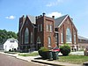
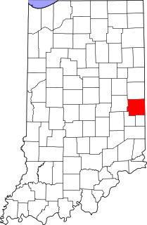
This is a list of the National Register of Historic Places listings in Wayne County, Indiana.

National Register of Historic Places listings in Delaware County, Indiana

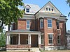
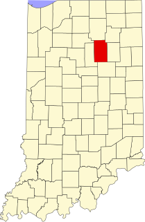
This is a list of the National Register of Historic Places listings in Delaware County, Indiana.

National Register of Historic Places listings in Bartholomew County, Indiana

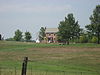
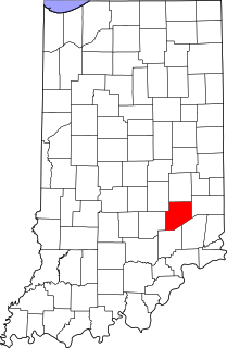
This is a list of the National Register of Historic Places listings in Bartholomew County, Indiana.

National Register of Historic Places listings in Wabash County, Indiana

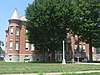
This is a list of the National Register of Historic Places listings in Wabash County, Indiana.

National Register of Historic Places listings in Adams County, Indiana

This is a list of the National Register of Historic Places listings in Adams County, Indiana.

National Register of Historic Places listings in Benton County, Indiana

This is a list of the National Register of Historic Places listings in Benton County, Indiana.

National Register of Historic Places listings in Blackford County, Indiana

This is a list of the National Register of Historic Places listings in Blackford County, Indiana.

National Register of Historic Places listings in Montgomery County, Indiana

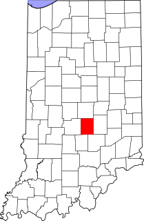
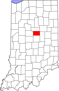
This is a list of the National Register of Historic Places listings in Montgomery County, Indiana.

National Register of Historic Places listings in Scott County, Indiana

This is a list of the National Register of Historic Places listings in Scott County, Indiana.

National Register of Historic Places listings in Wells County, Indiana

This is a list of the National Register of Historic Places listings in Wells County, Indiana.

National Register of Historic Places listings in Decatur County, Indiana

This is a list of the National Register of Historic Places listings in Decatur County, Indiana.

National Register of Historic Places listings in Fountain County, Indiana

This is a list of the National Register of Historic Places listings in Fountain County, Indiana.

National Register of Historic Places listings in Hendricks County, Indiana

This is a list of the National Register of Historic Places listings in Hendricks County, Indiana.

National Register of Historic Places listings in Howard County, Indiana

This is a list of the National Register of Historic Places listings in Howard County, Indiana.

National Register of Historic Places listings in Huntington County, Indiana

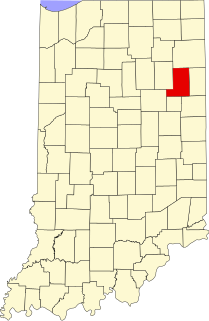
This is a list of the National Register of Historic Places listings in Huntington County, Indiana.

National Register of Historic Places listings in Johnson County, Indiana

This is a list of the National Register of Historic Places listings in Johnson County, Indiana.

National Register of Historic Places listings in Madison County, Indiana

This is a list of the National Register of Historic Places listings in Madison County, Indiana.

National Register of Historic Places listings in Miami County, Indiana

This is a list of the National Register of Historic Places listings in Miami County, Indiana.

National Register of Historic Places listings in Tipton County, Indiana

This is a list of the National Register of Historic Places listings in Tipton County, Indiana.

National Register of Historic Places listings in Kosciusko County, Indiana

This is a list of the National Register of Historic Places listings in Kosciusko County, Indiana.

References

  1. The latitude and longitude information provided in this table was derived originally from the National Register Information System, which has been found to be fairly accurate for about 99% of listings. Some locations in this table may have been corrected to current GPS standards.
  2. National Park Service, United States Department of the Interior, "National Register of Historic Places: Weekly List Actions", retrieved August 5, 2022.
  3. Numbers represent an alphabetical ordering by significant words. Various colorings, defined here, differentiate National Historic Landmarks and historic districts from other NRHP buildings, structures, sites or objects.
  4. "National Register Information System". National Register of Historic Places . National Park Service. March 13, 2009.
  5. The eight-digit number below each date is the number assigned to each location in the National Register Information System database, which can be viewed by clicking the number.