Point Isabel, Indiana

Last updated

Point Isabel, Indiana
Point Isabel, Indiana.jpg
Along State Road 26 in Point Isabel
Grant County Indiana Incorporated and Unincorporated areas Point Isabel Highlighted 1860894.svg
Location of Point Isabel in Grant County, Indiana.
USA Indiana location map.svg
Red pog.svg
Point Isabel
Usa edcp location map.svg
Red pog.svg
Point Isabel
Coordinates: 40°25′19″N85°49′22″W / 40.42194°N 85.82278°W / 40.42194; -85.82278
Country United States
State Indiana
County Grant
Township Green
Area
[1]
  Total0.57 sq mi (1.48 km2)
  Land0.57 sq mi (1.48 km2)
  Water0.00 sq mi (0.00 km2)
Elevation
[2]
876 ft (267 m)
Population
 (2020)
  Total114
  Density200.00/sq mi (77.21/km2)
ZIP code
46928
FIPS code 18-60894 [3]
GNIS feature ID2583464 [2]

Point Isabel is an unincorporated community and census-designated place (CDP) in central Green Township, Grant County, Indiana, United States. It lies at the intersection of State Roads 13 and 26. [4] As of the 2010 census it had a population of 91. [5]

Contents

A post office was established at Point Isabel in 1859, and remained in operation until it was discontinued in 1911. [6]

Photo from Small Town Indiana photo survey. Point-Isabel, Indiana.jpg
Photo from Small Town Indiana photo survey.

Geography

Point Isabel is located in southwestern Grant County. State Road 13 leads north 6 miles (10 km) to Swayzee and south 10 miles (16 km) to Elwood, while State Road 26 leads east 9 miles (14 km) to Fairmount and west 16 miles (26 km) to the southern outskirts of Kokomo. Marion, the Grant County seat, is 15 miles (24 km) to the northeast via State Roads 26 and 37.

Demographics

Historical population
CensusPop.Note
2020 114
U.S. Decennial Census [7]

Education

Residents are in the Madison-Grant United School Corporation. [8] Madison-Grant High School is the zoned high school.

Related Research Articles

<span class="mw-page-title-main">New Washington, Indiana</span> CDP in Indiana, United States

New Washington is a census-designated place (CDP) in Clark County, Indiana, United States. As of the 2010 census, the population was 566.

<span class="mw-page-title-main">Mexico, Indiana</span> Census-designated place in Indiana, United States

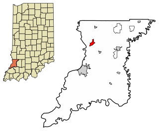
Mexico is an unincorporated community and census-designated place (CDP) in Jefferson Township, Miami County, in the U.S. state of Indiana. The population was 915 at the 2020 census.

<span class="mw-page-title-main">Pettisville, Ohio</span> Census-designated place in Ohio, United States

Pettisville is an unincorporated community and census-designated place (CDP) in Clinton and German townships, Fulton County, Ohio, United States. Located at the intersection of County Road 19 and Country Road D, its elevation is 755 feet (230 m). As of the 2020 census the population was 469.

<span class="mw-page-title-main">Canaan, Indiana</span> Census-designated place in Indiana, United States

Canaan is an unincorporated community and census-designated place (CDP) in Shelby Township, Jefferson County, Indiana, United States. As of the 2010 census it had a population of 90.

<span class="mw-page-title-main">Harlan, Indiana</span> Census-designated place in Indiana, United States

Harlan is an unincorporated census-designated place (CDP) in Springfield Township, Allen County, in the U.S. state of Indiana. As of the 2010 census, Harlan had a population of 1,634.

<span class="mw-page-title-main">Owensburg, Indiana</span> Census-designated place in Indiana, United States

Owensburg is an unincorporated community and census-designated place (CDP) in Jackson Township, Greene County, Indiana, United States. It was named in honor of the Owens family of early settlers. As of the 2010 census it had a population of 406.

<span class="mw-page-title-main">Deputy, Indiana</span> Census-designated place in Indiana, United States

Deputy is an unincorporated community and census-designated place (CDP) in Graham Township, Jefferson County, Indiana, United States. By road it is approximately 18 miles (29 km) northwest of Madison, the county seat. As of the 2010 census it had a population of 86.

<span class="mw-page-title-main">Emison, Indiana</span> Census-designated place in Indiana, United States

Emison is an unincorporated community and census-designated place (CDP) in Busseron Township, Knox County, Indiana. Its population was 154 at the 2010 census.

<span class="mw-page-title-main">Westphalia, Indiana</span> Census-designated place in Indiana, United States

Westphalia is an unincorporated community and census-designated place (CDP) in Vigo Township, Knox County, Indiana. As of the 2010 census it had a population of 202.

<span class="mw-page-title-main">Avoca, Indiana</span> Census-designated place in Indiana, United States

Avoca is an unincorporated community and census-designated place in Marshall Township, Lawrence County, Indiana, United States. As of the 2010 census the population was 583.

<span class="mw-page-title-main">Eminence, Indiana</span> Census-designated place in Indiana, United States

Eminence is an unincorporated community and census-designated place (CDP) in Adams Township, Morgan County, in the U.S. state of Indiana.

<span class="mw-page-title-main">Wheeler, Indiana</span> Census-designated place in Indiana, United States

Wheeler is an unincorporated census-designated place (CDP) in northern Union Township, Porter County, in the U.S. state of Indiana. It lies along State Road 130, northwest of the city of Valparaiso. Although Wheeler is unincorporated, it had a post office, with the ZIP code of 46393. The population of Wheeler was 443 at the 2010 census.

Robinette is an unincorporated community and census-designated place (CDP) in Logan County, West Virginia, United States, along Buffalo Creek. Its population was 663 as of the 2010 census. Prior to 2010, Robinette was part of the Amherstdale-Robinette CDP.

<span class="mw-page-title-main">Kingston, Arkansas</span> Census-designated place in Arkansas, United States

Kingston is an unincorporated community and census-designated place (CDP) in northeast Madison County, Arkansas, United States. It was first listed as a CDP in the 2020 census with a population of 97.

<span class="mw-page-title-main">Newcastle (CDP), Maine</span> Census-designated place in Maine, United States

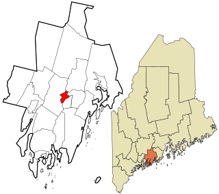
Newcastle is a census-designated place (CDP) comprising the main village of the town of Newcastle in Lincoln County, Maine, United States. The population was 667 at the 2010 census, out of 1,752 in the entire town. In the 2000 census, the village was part of the Damariscotta-Newcastle CDP.

Perkinsville is an unincorporated community and census-designated place (CDP) in Madison County, Indiana, in the United States.

<span class="mw-page-title-main">Landess, Indiana</span> Census-designated place in Indiana, United States

Landess is an unincorporated community and census-designated place (CDP) in Washington and Van Buren townships, Grant County, Indiana, in the United States. As of the 2010 census it had a population of 188.

<span class="mw-page-title-main">Mier, Indiana</span> Census-designated place in Indiana, United States

Mier is an unincorporated community and census-designated place (CDP) in Richland Township, Grant County, Indiana, in the United States. As of the 2010 census it had a population of 78.

<span class="mw-page-title-main">Painted Hills, Indiana</span> Census-designated place in Indiana, United States

Painted Hills is an unincorporated community and census-designated place (CDP) in Jackson Township, Morgan County, in the U.S. state of Indiana. Its population was 766 as of the 2020 census, up from 677 in 2010. The community is located on the shores of Lake Holiday and Lake Nebo southeast of Martinsville, the Morgan county seat. The two lakes are a combined 196 acres (79 ha) in size.

<span class="mw-page-title-main">Smithville-Sanders, Indiana</span> Census-designated place in Indiana, United States

Smithville-Sanders is a census-designated place (CDP) encompassing the communities of Smithville and Sanders in Monroe County, Indiana, United States. Its population was 3,323 as of the 2020 census.

References

  1. "2020 U.S. Gazetteer Files". United States Census Bureau. Retrieved March 16, 2022.
  2. 1 2 U.S. Geological Survey Geographic Names Information System: Point Isabel, Indiana
  3. "U.S. Census website". United States Census Bureau . Retrieved January 31, 2008.
  4. DeLorme. Indiana Atlas & Gazetteer. 3rd ed. Yarmouth: DeLorme, 2004, p. 33. ISBN   0-89933-319-2.
  5. "Geographic Identifiers: 2010 Demographic Profile Data (G001): Point Isabel CDP, Indiana". American Factfinder. U.S. Census Bureau. Retrieved December 5, 2016.[ dead link ]
  6. "Grant County". Jim Forte Postal History. Retrieved September 12, 2014.
  7. "Census of Population and Housing". Census.gov. Retrieved June 4, 2016.
  8. "SCHOOL DISTRICT REFERENCE MAP (2010 CENSUS): Grant County, IN" (Archive). U.S. Census Bureau. Retrieved on July 10, 2015.