Center Township, Ripley County, Indiana

Last updated
Center Township
Straber Ford Bridge.jpg
The Straber Ford Bridge, a local landmark
Map highlighting Center Township, Ripley County, Indiana.svg
Coordinates: 39°08′16″N85°18′16″W / 39.13778°N 85.30444°W / 39.13778; -85.30444 Coordinates: 39°08′16″N85°18′16″W / 39.13778°N 85.30444°W / 39.13778; -85.30444
Country United States
State Indiana
County Ripley
Government
  Type Indiana township
Area
  Total29.51 sq mi (76.4 km2)
  Land29.43 sq mi (76.2 km2)
  Water0.08 sq mi (0.2 km2)
Elevation
[1]
981 ft (299 m)
Population
 (2010)
  Total2,657
  Density90.3/sq mi (34.9/km2)
Area code(s) 812
FIPS code 18-11602 [2]
GNIS feature ID 453191

Center Township is one of eleven townships in Ripley County, Indiana. As of the 2010 census, its population was 2,657 and it contained 1,151 housing units. [3]

Contents

History

Straber Ford Bridge was listed on the National Register of Historic Places in 2009. [4]

Geography

According to the 2010 census, the township has a total area of 29.51 square miles (76.4 km2), of which 29.43 square miles (76.2 km2) (or 99.73%) is land and 0.08 square miles (0.21 km2) (or 0.27%) is water. [3]

Cities and towns

Unincorporated towns

Education

Center Township residents may obtain a free library card from the Osgood Public Library Central Library in Osgood, or its branch in Milan. [5]

Related Research Articles

Napoleon, Indiana Town in Indiana, United States

Napoleon is a town in Jackson Township, Ripley County, in the U.S. state of Indiana. The population was 234 at the 2010 census.

Adams Township, Carroll County, Indiana Township in Indiana, United States

Adams Township is one of fourteen townships in Carroll County, Indiana. As of the 2010 census, its population was 516 and it contained 209 housing units.

Iroquois Township, Newton County, Indiana Township in Indiana, United States

Iroquois Township is one of ten townships in Newton County, Indiana, United States. As of the 2010 census, its population was 1,358 and it contained 553 housing units.

Franklin Township, Putnam County, Indiana Township in Indiana, United States

Franklin Township is one of thirteen townships in Putnam County, Indiana. As of the 2010 census, its population was 1,690 and it contained 720 housing units.

Rock Creek Township, Carroll County, Indiana Township in Indiana, United States

Rock Creek Township is one of fourteen townships in Carroll County, Indiana. As of the 2010 census, its population was 475 and it contained 185 housing units.

Marion Township, Jasper County, Indiana Township in Indiana, United States

Marion Township is one of thirteen townships in Jasper County, Indiana, United States. As of the 2010 census, its population was 7,571 and it contained 2,989 housing units.

Winfield Township, Lake County, Indiana Township in Indiana, United States

Winfield Township is one of eleven townships in Lake County, Indiana. As of the 2010 census, its population was 10,054 and it contained 3,576 housing units.

New Durham Township, LaPorte County, Indiana Township in Indiana, United States

New Durham Township is one of twenty-one townships in LaPorte County, Indiana. As of the 2010 census, its population was 8,664 and it contained 2,396 housing units.

Center Township, Marshall County, Indiana Township in Indiana, United States

Center Township is one of ten townships in Marshall County, Indiana, United States. As of the 2010 census, its population was 15,593 and it contained 6,491 housing units.

Henry Township, Fulton County, Indiana Township in Indiana, United States

Henry Township is one of eight townships in Fulton County, Indiana. As of the 2010 census, its population was 3,048 and it contained 1,224 housing units.

Center Township, Dearborn County, Indiana Township in Indiana, United States

Center Township is one of fourteen townships in Dearborn County, Indiana. As of the 2010 census, its population was 5,318 and it contained 2,267 housing units.

Union Township, Delaware County, Indiana Township in Indiana, United States

Union Township is one of twelve townships in Delaware County, Indiana. According to the 2010 census, its population was 2,838 and it contained 1,260 housing units.

Metamora Township, Franklin County, Indiana Township in Indiana, United States

Metamora Township is one of thirteen townships in Franklin County, Indiana. As of the 2010 census, its population was 974.

Jefferson Township, Grant County, Indiana Township in Indiana, United States

Jefferson Township is one of thirteen townships in Grant County, Indiana, United States. As of the 2010 census, its population was 5,839 and it contained 1,758 housing units.

Monroe Township, Grant County, Indiana Township in Indiana, United States

Monroe Township is one of thirteen townships in Grant County, Indiana, United States. As of the 2010 census, its population was 1,677 and it contained 669 housing units.

Driftwood Township, Jackson County, Indiana Township in Indiana, United States

Driftwood Township is one of twelve townships in Jackson County, Indiana, United States. As of the 2010 census, its population was 860 and it contained 365 housing units.

Washington Township, Kosciusko County, Indiana Township in Indiana, United States

Washington Township is one of seventeen townships in Kosciusko County, Indiana. As of the 2010 census, its population was 2,996 and it contained 1,335 housing units.

Delaware Township, Ripley County, Indiana Township in Indiana, United States

Delaware Township is one of eleven townships in Ripley County, Indiana. As of the 2010 census, its population was 1,437 and it contained 578 housing units.

Franklin Township, Ripley County, Indiana Township in Indiana, United States

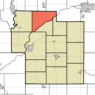
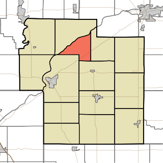
Franklin Township is one of eleven townships in Ripley County, Indiana. As of the 2010 census, its population was 3,773 and it contained 1,541 housing units.

Washington Township, Ripley County, Indiana Township in Indiana, United States

Washington Township is one of eleven townships in Ripley County, Indiana. As of the 2010 census, its population was 2,440 and it contained 934 housing units.

References

  1. "US Board on Geographic Names". United States Geological Survey. 2007-10-25. Retrieved 2008-01-31.
  2. "U.S. Census website". United States Census Bureau . Retrieved 2008-01-31.
  3. 1 2 "Population, Housing Units, Area, and Density: 2010 - County -- County Subdivision and Place -- 2010 Census Summary File 1". United States Census. Archived from the original on 2020-02-12. Retrieved 2013-05-10.
  4. "National Register Information System". National Register of Historic Places . National Park Service. July 9, 2010.
  5. "Library services". Osgood Public Library. Archived from the original on 15 March 2018. Retrieved 14 March 2018.