DeMotte, Indiana

Last updated

DeMotte, Indiana
Demotte Indiana.JPG
U.S. Route 231 through DeMotte, Indiana
Jasper County Indiana Incorporated and Unincorporated areas De Motte Highlighted 1817722.svg
Location of De Motte in Jasper County, Indiana.
Coordinates: 41°11′56″N87°11′50″W / 41.19889°N 87.19722°W / 41.19889; -87.19722 [1]
Country United States
State Indiana
County Jasper
Township Keener
Area
[2]
  Total3.59 sq mi (9.29 km2)
  Land3.59 sq mi (9.29 km2)
  Water0.00 sq mi (0.00 km2)
Elevation
[1]
669 ft (204 m)
Population
 (2020)
  Total4,168
  Density1,162.30/sq mi (448.78/km2)
Time zone UTC-6 (CST)
  Summer (DST) UTC-5 (CDT)
ZIP code
46310
Area code 219
FIPS code 18-17722 [3]
GNIS feature ID2396683 [1]
Website www.townofdemotte.com

DeMotte is a town in Keener Township, Jasper County, Indiana, United States. The population was 3,814 at the 2010 census.

Contents

History

DeMotte was made a station by the New York Central Railroad when the line was extended to that point in the early 1880s. [4] The DeMotte post office opened in 1882. [5] DeMotte was named for Mark L. De Motte, a member of Congress at the time. [6]

Geography

According to the 2010 census, De Motte has a total area of 3.61 square miles (9.35 km2), all land. [7]

U.S. Route 231 and Indiana State Road 10 run through DeMotte.

Demographics

Historical population
CensusPop.Note
1970 1,697
1980 2,55950.8%
1990 2,482−3.0%
2000 3,23430.3%
2010 3,81417.9%
2020 4,1689.3%
U.S. Decennial Census [8]

2010 census

As of the census [9] of 2010, there were 3,814 people, 1,560 households, and 1,062 families living in the town. The population density was 1,056.5 inhabitants per square mile (407.9/km2). There were 1,668 housing units at an average density of 462.0 per square mile (178.4/km2). The racial makeup of the town was 96.2% White, 0.4% African American, 0.3% Native American, 0.4% Asian, 1.4% from other races, and 1.3% from two or more races. Hispanic or Latino of any race were 4.7% of the population.

There were 1,560 households, of which 31.3% had children under the age of 18 living with them, 53.4% were married couples living together, 9.9% had a female householder with no husband present, 4.8% had a male householder with no wife present, and 31.9% were non-families. 28.8% of all households were made up of individuals, and 16.5% had someone living alone who was 65 years of age or older. The average household size was 2.42 and the average family size was 2.93.

The median age in the town was 39.4 years. 24.4% of residents were under the age of 18; 7.2% were between the ages of 18 and 24; 24.5% were from 25 to 44; 23.4% were from 45 to 64; and 20.7% were 65 years of age or older. The gender makeup of the town was 46.5% male and 53.5% female.

2000 census

As of the census [3] of 2000, there were 3,234 people, 1,297 households, and 897 families living in the town. The population density was 900.7 inhabitants per square mile (347.8/km2). There were 1,361 housing units at an average density of 379.1 per square mile (146.4/km2). The racial makeup of the town was 99.01% White, 0.06% African American, 0.06% Native American, 0.06% Asian, 0.25% from other races, and 0.56% from two or more races. Hispanic or Latino of any race were 1.61% of the population.

There were 1,297 households, out of which 30.8% had children under the age of 18 living with them, 58.8% were married couples living together, 7.2% had a female householder with no husband present, and 30.8% were non-families. 28.3% of all households were made up of individuals, and 17.1% had someone living alone who was 65 years of age or older. The average household size was 2.44 and the average family size was 2.98.

In the town, the population was spread out, with 25.0% under the age of 18, 7.5% from 18 to 24, 26.5% from 25 to 44, 20.1% from 45 to 64, and 20.9% who were 65 years of age or older. The median age was 38 years. For every 100 females, there were 88.4 males. For every 100 females age 18 and over, there were 83.8 males.

The median income for a household in the town was $37,557, and the median income for a family was $44,583. Males had a median income of $36,705 versus $22,941 for females. The per capita income for the town was $19,059. About 7.0% of families and 7.7% of the population were below the poverty line, including 7.5% of those under age 18 and 6.5% of those age 65 or over.

Notable person

Charles A. Halleck, a Republican leader in the U.S. House of Representatives between 1935 and 1968, was born near DeMotte in 1900.

Education

The Kankakee Valley School Corporation serves DeMotte. DeMotte Elementary School is located in DeMotte. [10] Residents are served by Kankakee Valley Intermediate School, Kankakee Valley Middle School, and Kankakee Valley High School in Wheatfield Township. [11] [12] [13]

DeMotte has a public library, a branch of the Jasper County Public Library. [14]

Covenant Christian High School and DeMotte Christian School (Pre-school through 8th grade) are located in DeMotte. In 1940, DeMotte Christian School was organized by a group of parents from the First Christian Reformed Church of DeMotte.

Festivals

Touch of Dutch – This festival takes place each year early in August as a celebration of the Dutch American heritage in the DeMotte area. Many area businesses have vendor tents set up in downtown DeMotte for people to visit.[ citation needed ]

Related Research Articles

<span class="mw-page-title-main">Jasper County, Indiana</span> County in Indiana, United States

Jasper County is a county located in the U.S. state of Indiana. As of 2020, the population was 32,918. The county seat is Rensselaer.

<span class="mw-page-title-main">Aroma Park, Illinois</span> Village in Illinois, United States

Aroma Park is a village in Kankakee County, Illinois, United States, along the Kankakee River opposite the mouth of the Iroquois River. Aroma Park is a suburb of the city of Kankakee. Aroma Park's population was 743 at the 2010 census, down from 821 at the 2000 census. It is included in the Kankakee-Bradley, Illinois Metropolitan Statistical Area.

<span class="mw-page-title-main">Ambia, Indiana</span> Town in Indiana, United States

Ambia is a town in Hickory Grove Township, Benton County, Indiana, United States. The population was 239 at the 2010 census. It is part of the Lafayette, Indiana Metropolitan Statistical Area.

<span class="mw-page-title-main">Earl Park, Indiana</span> Town in Indiana, United States

Earl Park is a town in Richland Township, Benton County, Indiana, United States. The population was 348 at the 2010 census. It is part of the Lafayette, Indiana Metropolitan Statistical Area.

<span class="mw-page-title-main">Otterbein, Indiana</span> Town in Indiana, United States

Otterbein is a town in Shelby Township, Tippecanoe County and Bolivar Township, Benton County, Indiana, named for William Otterbein Brown who donated land for the town. As of the 2010 census, its population was 1,262.

<span class="mw-page-title-main">Switz City, Indiana</span> Town in Indiana, United States

Switz City is a town in Fairplay and Grant townships, Greene County, Indiana, United States. The population was 293 at the 2010 census. It is part of the Bloomington, Indiana, Metropolitan Statistical Area.

<span class="mw-page-title-main">Collegeville, Indiana</span> Census-designated place in Indiana, United States

Collegeville is a census-designated place (CDP) in Jasper County, Indiana, United States. The population was 330 at the 2010 census. Collegeville is home to the now-unaccredited Saint Joseph's College, the source of the town's name.

<span class="mw-page-title-main">Remington, Indiana</span> Town in Indiana, United States

Remington is a town in Carpenter Township, Jasper County, Indiana, United States. The population was 1,185 at the 2010 census.

<span class="mw-page-title-main">Rensselaer, Indiana</span> City in Indiana, United States

Rensselaer is a city located along the Iroquois River in Marion Township, Jasper County, Indiana, United States. The population was 5,859 at the 2010 census, up from 5,294 at the 2000 census. The city is the county seat of Jasper County. Saint Joseph's College is located just south of the city limits.

<span class="mw-page-title-main">Roselawn, Indiana</span> Census-designated place in Indiana, United States

Roselawn is a census-designated place (CDP) in Newton and Jasper counties in the U.S. state of Indiana. The population was 4,131 at the 2010 census.

<span class="mw-page-title-main">Wheatfield, Indiana</span> Town in Indiana, United States

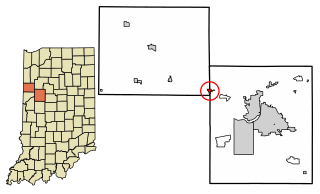
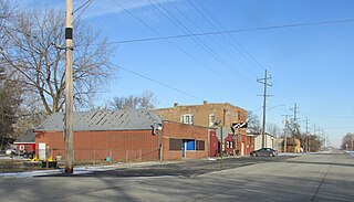
Wheatfield is a town in Wheatfield Township, Jasper County, Indiana, United States. The population was 904 at the 2020 census.

<span class="mw-page-title-main">Lowell, Indiana</span> Town in Indiana, United States

Lowell is a town in West Creek and Cedar Creek townships, Lake County, Indiana, United States. The population was 10,680 at the 2020 census.

<span class="mw-page-title-main">Schneider, Indiana</span> Town in Indiana, United States

Schneider is a town in West Creek Township, Lake County, Indiana, United States. The population was 277 at the 2010 census. It is the smallest incorporated town in Lake County by population. It sits in the Kankakee River Valley.

<span class="mw-page-title-main">Rockville, Indiana</span> Town in Indiana, United States

Rockville is a town in Adams Township, Parke County, in the U.S. state of Indiana. The population was 2,607 at the 2010 census. The town is the county seat of Parke County. It is known as "The Covered Bridge Capital of the World".

<span class="mw-page-title-main">Francesville, Indiana</span> Town in Indiana, United States

Francesville is a town in Salem Township, Pulaski County, in the U.S. state of Indiana. The population was 852 at the 2020 census. The motto for Francesville is “A small town with a big heart.”

<span class="mw-page-title-main">Hamlet, Indiana</span> Town in Starke County, Indiana, United States

Hamlet is a town in Davis and Oregon Townships, Starke County, in the U.S. state of Indiana. The population was 800 as of the 2010 census.

<span class="mw-page-title-main">Brush Valley Township, Pennsylvania</span> Township in Pennsylvania, United States

Brush Valley Township is a township in Indiana County, Pennsylvania, United States. Brush Valley Township was formed from Wheatfield Township in 1835, and named for the valley of Brush Creek. The population was 1,695 at the 2020 census. It includes the communities of Brush Valley, Claghorn, Dias, Heshbon, Littletown, Rico, and Suncliff.

<span class="mw-page-title-main">East Wheatfield Township, Indiana County, Pennsylvania</span> Township in Pennsylvania, United States

East Wheatfield Township is a township in Indiana County, Pennsylvania, United States. East Wheatfield Township was created when the original Wheatfield Township was divided in 1859 into East and West Wheatfield. It was named for the large unforested areas naturally occurring there which were ideal for growing wheat. The population was 2,161 at the 2020 census, a decline from the figure of 2,366 tabulated in 2010. It includes the communities of Boltz, Cramer, Gas Center, Ninevah, Robindale, Shoupstown, Virginia, and Wheatfield. It surrounds, but does not include, the borough of Armagh.

<span class="mw-page-title-main">West Wheatfield Township, Pennsylvania</span> Township in Pennsylvania, United States

West Wheatfield Township is a township in Indiana County, Pennsylvania, United States. The population was 2,164 at the time of the 2020 census.

Kankakee Valley School Corporation is a school district in Indiana, headquartered in Wheatfield Township, near Wheatfield.

References

  1. 1 2 3 U.S. Geological Survey Geographic Names Information System: DeMotte, Indiana
  2. "2020 U.S. Gazetteer Files". United States Census Bureau. Retrieved March 16, 2022.
  3. 1 2 "U.S. Census website". United States Census Bureau . Retrieved January 31, 2008.
  4. A standard history of Jasper and Newton counties, Indiana. Lewis Publishing Company. 1916. pp. 74–75.
  5. "Jasper County". Jim Forte Postal History. Archived from the original on October 21, 2014. Retrieved October 21, 2014.
  6. Baker, Ronald L. (October 1995). From Needmore to Prosperity: Hoosier Place Names in Folklore and History . Indiana University Press. p.  112. ISBN   978-0-253-32866-3. The name honors Congressman Mark L. DeMotte...
  7. "G001 – Geographic Identifiers – 2010 Census Summary File 1". United States Census Bureau. Archived from the original on February 13, 2020. Retrieved July 16, 2015.
  8. "Census of Population and Housing". Census.gov. Retrieved June 4, 2015.
  9. "U.S. Census website". United States Census Bureau . Retrieved December 11, 2012.
  10. "DeMotte Elementary School Archived 2012-10-08 at the Wayback Machine ." Kankakee Valley School Corporation. Retrieved on December 26, 2012.
  11. Home Archived December 24, 2012, at the Wayback Machine . Kankakee Valley High School. Retrieved on December 26, 2012. "3923 W. State Road 10 Wheatfield, Indiana, USA 46392-9267"
  12. "Welcome To Kankakee Valley Middle School Archived 2013-02-04 at the Wayback Machine ." Kankakee Valley Middle School. Retrieved on December 26, 2012. "5258 W St Rd 10 Wheatfield, Indiana, USA 46392-9267"
  13. "Kankakee Valley Intermediate School Archived 2012-12-24 at the Wayback Machine ." Kankakee Valley School Corporation. Retrieved on December 26, 2012. "12345 N 550 W Wheatfield, IN 46392"
  14. "DeMotte Public Library". Jasper County Public Library. Retrieved March 8, 2018.