Remington, Indiana

Last updated

Remington, Indiana
Town
Station 20-02-18 015.jpg
Panhandle Railway Station.
Remington, Indiana.gif
Jasper County Indiana Incorporated and Unincorporated areas Remington Highlighted 1863756.svg
Location of Remington in Jasper County, Indiana.
Coordinates: 40°46′00″N87°08′21″W / 40.76667°N 87.13917°W / 40.76667; -87.13917 [1]
CountryUnited States
State Indiana
County Jasper
Township Carpenter
Platted1860
Area
[2]
  Total3.84 sq mi (9.95 km2)
  Land3.81 sq mi (9.88 km2)
  Water0.03 sq mi (0.07 km2)
Elevation
[1]
725 ft (221 m)
Population
 (2020)
  Total1,356
  Density355.53/sq mi (137.26/km2)
Time zone UTC-6 (Central Standard Time (CST))
  Summer (DST) UTC-5 (CDT)
ZIP code
47977
Area code 219
FIPS code 18-63756 [3]
GNIS feature ID2396873 [1]
Website http://remingtonindiana.com/

Remington is a town in Carpenter Township, Jasper County, Indiana, United States. The population was 1,185 at the 2010 census.

Contents

History

Remington was first laid out in 1860 by Jesse H. Fordice. It was originally called Carpenter Station, after Carpenter's Creek where a railroad station had been established, around which the town grew. The name was later changed to Remington, after the founder of the general store. [4] The main trade was in grain, as the area consisted of excellent prairie farmland; the town's position on the Pittsburgh, Chicago and St. Louis Railroad made it a good location for such trade. The first grain elevator was built in 1870 by Church and Hartley; the second was built by the Hathaway Brothers in 1872; and in 1879, James Irvin built a third. In 1883 the population was about 900. [5]

Remington Water Tower and Town Hall was listed on the National Register of Historic Places in 2003. [6]

Geography

Remington is located about 90 miles northwest of Indianapolis and about 90 miles southeast of Chicago. It is about a mile west of Interstate 65; U.S. Route 24 and U.S. Route 231 pass through the town. Remington is located in the CST Time Zone.

According to the 2010 census, Remington has a total area of 1.02 square miles (2.64 km2), all land. [7]

Demographics

Historical population
CensusPop.Note
1870 390
1880 76195.1%
1890 94023.5%
1900 1,12019.1%
1910 982−12.3%
1920 1,0446.3%
1930 879−15.8%
1940 869−1.1%
1950 1,05321.2%
1960 1,20714.6%
1970 1,127−6.6%
1980 1,26812.5%
1990 1,247−1.7%
2000 1,3236.1%
2010 1,185−10.4%
2020 1,35614.4%
U.S. Decennial Census [8]
Original 1897 water tank Remington Water Tower Indiana.JPG
Original 1897 water tank

2010 census

As of the census [9] of 2010, there were 1,185 people, 503 households, and 329 families living in the town. The population density was 1,161.8 inhabitants per square mile (448.6/km2). There were 569 housing units at an average density of 557.8 per square mile (215.4/km2). The racial makeup of the town was 96.5% White, 0.6% African American, 0.1% Native American, 0.3% Asian, 0.1% Pacific Islander, 0.3% from other races, and 2.2% from two or more races. Hispanic or Latino of any race were 3.1% of the population.

There were 503 households, of which 33.2% had children under the age of 18 living with them, 48.1% were married couples living together, 10.3% had a female householder with no husband present, 7.0% had a male householder with no wife present, and 34.6% were non-families. 29.6% of all households were made up of individuals, and 14.1% had someone living alone who was 65 years of age or older. The average household size was 2.36 and the average family size was 2.91.

The median age in the town was 39.8 years. 24.8% of residents were under the age of 18; 8.6% were between the ages of 18 and 24; 23.2% were from 25 to 44; 27.3% were from 45 to 64; and 16.1% were 65 years of age or older. The gender makeup of the town was 48.8% male and 51.2% female.

2000 census

As of the census [3] of 2000, there were 1,323 people, 532 households, and 353 families living in the town. The population density was 1,279.7 inhabitants per square mile (494.1/km2). There were 557 housing units at an average density of 538.8 per square mile (208.0/km2). The racial makeup of the town was 98.72% White, 0.15% African American, 0.68% Asian, 0.08% from other races, and 0.38% from two or more races. Hispanic or Latino of any race were 1.06% of the population.

There were 532 households, out of which 33.5% had children under the age of 18 living with them, 53.9% were married couples living together, 8.6% had a female householder with no husband present, and 33.6% were non-families. 28.2% of all households were made up of individuals, and 14.8% had someone living alone who was 65 years of age or older. The average household size was 2.49 and the average family size was 3.06.

In the town, the population was spread out, with 27.7% under the age of 18, 9.1% from 18 to 24, 27.9% from 25 to 44, 20.8% from 45 to 64, and 14.5% who were 65 years of age or older. The median age was 36 years. For every 100 females, there were 94.0 males. For every 100 females age 18 and over, there were 85.5 males.

The median income for a household in the town was $37,037, and the median income for a family was $45,735. Males had a median income of $34,135 versus $20,833 for females. The per capita income for the town was $17,184. About 4.4% of families and 7.5% of the population were below the poverty line, including 8.4% of those under age 18 and 7.1% of those age 65 or over.

Education

The town has a lending library, the Remington-Carpenter Township Public Library. [10]

Notable people

Related Research Articles

<span class="mw-page-title-main">Fowler, Indiana</span> Town in Indiana, United States

Fowler is a town in, and county seat of Center Township, Benton County, Indiana, United States. The population was 2,337 at the 2020 census. It is part of the Lafayette, Indiana Metropolitan Statistical Area.

<span class="mw-page-title-main">Advance, Indiana</span> Town in Indiana, United States

Advance is a town in Jackson Township, Boone County, Indiana, United States. The population was 503 at the 2020 census.

<span class="mw-page-title-main">Alfordsville, Indiana</span> Town in Indiana, United States

Alfordsville is a town in Reeve Township, Daviess County, Indiana, United States. The population was 101 at the 2010 census.

<span class="mw-page-title-main">Birdseye, Indiana</span> Town in Indiana, United States

Birdseye is a town in Jefferson Township, Dubois County, in the U.S. state of Indiana. At the 2010 census, the town population was 415.

<span class="mw-page-title-main">Cumberland, Indiana</span> Town in Indiana, United States

Cumberland is a town in Hancock and Marion counties, Indiana, United States. The population was 5,954 at the 2020 census, up from 5,169 in 2010.

<span class="mw-page-title-main">Mount Summit, Indiana</span> Town in Indiana, United States

Mount Summit is a town in Prairie Township, Henry County, Indiana, United States. The population was 352 at the 2010 census.

<span class="mw-page-title-main">Rensselaer, Indiana</span> City in Indiana, United States

Rensselaer is a city located along the Iroquois River in Marion Township, Jasper County, Indiana, United States. The population was 5,859 at the 2010 census, up from 5,294 at the 2000 census. The city is the county seat of Jasper County. Saint Joseph's College is located just south of the city limits.

<span class="mw-page-title-main">Wheatfield, Indiana</span> Town in Indiana, United States

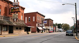
Wheatfield is a town in Wheatfield Township, Jasper County, Indiana, United States. The population was 904 at the 2020 census.

<span class="mw-page-title-main">Etna Green, Indiana</span> Town in Indiana, United States

Etna Green is a town in Etna Township, Kosciusko County, in the U.S. state of Indiana. The population was 586 at the 2010 census.

<span class="mw-page-title-main">Pierceton, Indiana</span> Town in Indiana, United States

Pierceton is a town in Washington Township, Kosciusko County, in the U.S. state of Indiana. The population was 928 at the 2020 census.

<span class="mw-page-title-main">New Chicago, Indiana</span> Town in Indiana, United States

New Chicago is a town in Hobart Township, Lake County, Indiana, United States. The population was 2,035 at the 2010 census.

<span class="mw-page-title-main">Morgantown, Indiana</span> Town in Indiana, United States

Morgantown is a town at the intersection of Indiana state routes 135 and 252 in Jackson Township, Morgan County, in the U.S. state of Indiana. The population was 1,014 at the 2020 census.

<span class="mw-page-title-main">Spurgeon, Indiana</span> Town in Indiana, United States

Spurgeon is a town in Monroe Township, Pike County, in the U.S. state of Indiana. The population was 207 at the 2010 census. It is part of the Jasper Micropolitan Statistical Area.

<span class="mw-page-title-main">Winslow, Indiana</span> Town in Indiana, United States

Winslow is a town in Patoka Township, Pike County, in the U.S. state of Indiana. The population was 864 at the 2010 census. It is part of the Jasper Micropolitan Statistical Area.

<span class="mw-page-title-main">Chrisney, Indiana</span> Town in Indiana, United States

Chrisney is a town in Grass Township, Spencer County, in the U.S. state of Indiana. The population was 481 at the 2010 census.

<span class="mw-page-title-main">Patriot, Indiana</span> Town in Indiana, United States

Patriot is a town in Posey Township, Switzerland County, in the U.S. state of Indiana, along the Ohio River. The population was 209 at the 2010 census.

<span class="mw-page-title-main">Wolcott, Indiana</span> Town in Indiana, United States

Wolcott is a town in Princeton Township, White County, in the U.S. state of Indiana. The population was 1,001 at the 2010 census.

<span class="mw-page-title-main">Hartford, Maine</span> Town in the state of Maine, United States

Hartford is a town in Oxford County, Maine, United States. Hartford is included in the Lewiston-Auburn, Maine metropolitan New England City and Town Area. The population was 1,203 at the 2020 census.

<span class="mw-page-title-main">Warren Park, Indiana</span> Town in Indiana, United States

Warren Park is a town in Warren Township, Marion County, Indiana, United States. The population was 1,490 at the 2020 census. It has existed as an "included town" since 1970, when it was incorporated into Indianapolis as part of Unigov. It is part of Indianapolis, but retains a functioning town government under IC 36-3-1-11.

<span class="mw-page-title-main">Mazomanie (town), Wisconsin</span>

Mazomanie is a town in Dane County, Wisconsin. The population was 1,185 at the time of the 2000 census. The Village of Mazomanie is located within the town.

References

  1. 1 2 3 U.S. Geological Survey Geographic Names Information System: Remington, Indiana
  2. "2020 U.S. Gazetteer Files". United States Census Bureau. Retrieved March 16, 2022.
  3. 1 2 "U.S. Census website". United States Census Bureau . Retrieved January 31, 2008.
  4. A standard history of Jasper and Newton counties, Indiana. Lewis Publishing Company. 1916. p. 154.
  5. Battle, J. H. (1883). "History of Jasper County". Counties of Warren, Benton, Jasper, and Newton, Indiana. Chicago, Illinois: F. A. Battey and Company. pp. 517–519.
  6. "National Register Information System". National Register of Historic Places . National Park Service. July 9, 2010.
  7. "G001 - Geographic Identifiers - 2010 Census Summary File 1". United States Census Bureau. Archived from the original on February 13, 2020. Retrieved July 17, 2015.
  8. "Census of Population and Housing". Census.gov. Retrieved June 4, 2015.
  9. "U.S. Census website". United States Census Bureau . Retrieved December 11, 2012.
  10. "Indiana public library directory" (PDF). Indiana State Library. Retrieved March 7, 2018.