Westville, Indiana

Last updated

Westville, Indiana
Westville, Indiana water tower.jpg
Westville, Indiana water tower, built in the 1930s
Motto: 
Community of Progress
LaPorte County Indiana Incorporated and Unincorporated areas Westville Highlighted 1883420.svg
Location of Westville in LaPorte County, Indiana.
Coordinates: 41°32′15″N86°54′18″W / 41.53750°N 86.90500°W / 41.53750; -86.90500
Country United States
State Indiana
County LaPorte
Township New Durham
Area
[1]
  Total3.25 sq mi (8.42 km2)
  Land3.25 sq mi (8.42 km2)
  Water0.00 sq mi (0.00 km2)
Elevation
[2]
774 ft (236 m)
Population
 (2020)
  Total5,257
  Density1,617.04/sq mi (624.34/km2)
Time zone UTC-6 (Central (CST))
  Summer (DST) UTC-5 (CDT)
ZIP code
46391
Area code 219
FIPS code 18-83420 [3]
GNIS feature ID2397737 [2]
Website http://www.westville.us

Westville is a town in New Durham Township, LaPorte County, Indiana, United States. The population, as of the 2020 census is 5257. It is included in the Michigan City, Indiana-La Porte, Indiana Metropolitan Statistical Area. Westville is located in Northwest Indiana, also known as The Region.

Contents

History

Westville was platted in 1851, and incorporated as a town in 1864. [4] It was a station and shipping point at the junction of two railroads. [5]

Rev. John Milton Whitehead lived in Westville at the time of his enlistment as a chaplain in the 15th Indiana Infantry Regiment. Whitehead received the Medal of Honor for his actions at the Battle of Stones River when he "went to the front during a desperate contest and unaided carried to the rear several wounded and helpless soldiers."

The Everel S. Smith House was listed in the National Register of Historic Places in 1990. [6]

Geography

According to the 2010 census, Westville has a total area of 3.09 square miles (8.00 km2), all land. [7]

Demographics

Historical population
CensusPop.Note
1870 640
1880 627−2.0%
1890 522−16.7%
1900 468−10.3%
1910 5037.5%
1920 408−18.9%
1930 49621.6%
1940 5235.4%
1950 62419.3%
1960 78926.4%
1970 2,614231.3%
1980 2,88710.4%
1990 2,255−21.9%
2000 2,116−6.2%
2010 5,853176.6%
2020 5,257−10.2%
U.S. Decennial Census [8]

Note that the census data for 2010 and later include the Westville Correctional Facility.

2010 census

As of the census [9] of 2010, there were 5,853 people, 1,093 households, and 705 families living in the town. The population density was 1,894.2 inhabitants per square mile (731.4/km2). There were 1,186 housing units at an average density of 383.8 per square mile (148.2/km2). The racial makeup of the town was 72.1% White, 25.1% African American, 0.2% Native American, 0.3% Asian, 1.6% from other races, and 0.7% from two or more races. Hispanic or Latino of any race were 6.3% of the population.

There were 1,093 households, of which 34.2% had children under the age of 18 living with them, 44.1% were married couples living together, 12.9% had a female householder with no husband present, 7.5% had a male householder with no wife present, and 35.5% were non-families. 29.2% of all households were made up of individuals, and 8.9% had someone living alone who was 65 years of age or older. The average household size was 2.45 and the average family size was 2.97.

The median age in the town was 33.1 years. 12% of residents were under the age of 18; 13.7% were between the ages of 18 and 24; 47.3% were from 25 to 44; 21.4% were from 45 to 64; and 5.5% were 65 years of age or older. The gender makeup of the town was 76.9% male and 23.1% female.

2000 census

As of the census [3] of 2000, there were 2,116 people, 897 households, and 556 families living in the town. The population density was 677.0 inhabitants per square mile (261.4/km2). There were 984 housing units at an average density of 314.8 per square mile (121.5/km2). The racial makeup of the town was 96.27% White, 1.23% African American, 0.28% Native American, 0.28% Asian, 0.71% from other races, and 1.23% from two or more races. Hispanic or Latino of any race were 0.90% of the population.

There were 898 households, out of which 30.8% had children under the age of 18 living with them, 45.4% were married couples living together, 12.0% had a female householder with no husband present, and 38.0% were non-families. 30.4% of all households were made up of individuals, and 11.0% had someone living alone who was 65 years of age or older. The average household size was 2.36 and the average family size was 2.93.

In the town, the population was spread out, with 26.0% under the age of 18, 8.1% from 18 to 24, 31.0% from 25 to 44, 23.1% from 45 to 64, and 11.7% who were 65 years of age or older. The median age was 36 years. For every 100 females, there were 96.1 males. For every 100 females age 18 and over, there were 95.1 males.

The median income for a household in the town was $36,761, and the median income for a family was $44,524. Males had a median income of $33,906 versus $21,525 for females. The per capita income for the town was $18,306. About 3.3% of families and 6.3% of the population were below the poverty line, including 6.0% of those under age 18 and 4.2% of those age 65 or over.

Education

The town has a lending library, the Westville-New Durham Township Public Library. [10] Westville residents may also request a free library card from any La Porte County Public Library branch. [11] Purdue University Northwest's other campus, formerly Purdue North Central, is in Westville.

Related Research Articles

<span class="mw-page-title-main">Dunkirk, Indiana</span> City in Indiana, United States

Dunkirk is a city in Blackford and Jay counties in the U.S. state of Indiana. The population was 2,164 at the 2020 census.

<span class="mw-page-title-main">Odon, Indiana</span> Town in Indiana, United States

Odon is a town in Madison Township, Daviess County, Indiana, United States. The population was 1,354 at the 2010 census.

<span class="mw-page-title-main">Laurel, Indiana</span> Town in Indiana, United States

Laurel is a town in Laurel Township, Franklin County, Indiana, United States. The population was 512 at the 2010 census.

<span class="mw-page-title-main">Worthington, Indiana</span> Town in Indiana, United States

Worthington is a town in Jefferson Township, Greene County, Indiana, United States. The population was 1,463 at the 2010 United States Census. It is part of the Bloomington, Indiana, Metropolitan Statistical Area.

<span class="mw-page-title-main">Fortville, Indiana</span> Town in Indiana, United States

Fortville is a town in Vernon Township, Hancock County, Indiana, United States. The population was 4,784 at the 2020 census.

<span class="mw-page-title-main">Coatesville, Indiana</span> Town in Indiana, United States

Coatesville is a town in Clay Township, Hendricks County, Indiana, United States. The population was 523 at the 2010 Census.

<span class="mw-page-title-main">Andrews, Indiana</span> Town in Indiana, United States

Andrews is a town in Dallas Township, Huntington County, Indiana, United States. The population was 1,048 at the 2020 census.

<span class="mw-page-title-main">Kingsbury, Indiana</span> Town in Indiana, United States

Kingsbury is a town in Washington Township, LaPorte County, Indiana, just northwest of the intersection of U.S. Route 35 and U.S. Route 6. The town was founded in 1835 and incorporated on March 3, 1941. During 1940 - 1941, the Kingsbury Ordnance Plant (KOP) was built for use during World War II. The plant closed after the war but reopened during the Korean War, closing permanently in 1959. The population was 242 at the 2010 census. It is included in the Michigan City, Indiana-La Porte, Indiana Metropolitan Statistical Area. The town has its own fire department, KVFD, and a Greek revival style First Baptist church built in 1851 with its own graveyard and Winchell Cemetery.

<span class="mw-page-title-main">Kingsford Heights, Indiana</span> Town in Indiana, United States

Kingsford Heights is a town in Union Township, LaPorte County, Indiana, United States. The population was 1,335 at the 2020 census. It is included in the Michigan City, Indiana-La Porte, Indiana Metropolitan Statistical Area. Also known as "Victory City," the town was built by the United States government for workers that worked in the Kingsbury Ordnance Plant, an ammunitions plant that served the US during World War II and later the Korean War.

<span class="mw-page-title-main">La Crosse, Indiana</span> Town in Indiana, United States

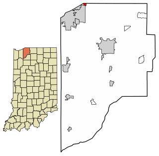
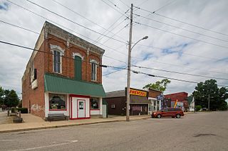
La Crosse is a town in LaPorte County, Indiana, United States. The population was 551 at the 2010 census. It is included in the Michigan City, Indiana-La Porte, Indiana Metropolitan Statistical Area.

<span class="mw-page-title-main">Long Beach, Indiana</span> Town in Indiana, United States

Long Beach is a town in Michigan Township, LaPorte County, Indiana, United States. As of the 2010 census, the population of Long Beach was 1,179. It is included in the Michigan City, Indiana-La Porte, Indiana Metropolitan Statistical Area.

<span class="mw-page-title-main">Michiana Shores, Indiana</span> Town in Indiana, United States

Michiana Shores is a town in Springfield and Michigan townships, LaPorte County, Indiana, United States. The population was 313 at the 2010 census. It is included in the Michigan City, Indiana-La Porte, Indiana Metropolitan Statistical Area. Michiana Shores is located in northwesternmost Springfield Township, and is the township's sole incorporated community.

<span class="mw-page-title-main">Pottawattamie Park, Indiana</span> Town in Indiana, United States

Pottawattamie Park is a town in Michigan Township, LaPorte County, Indiana, United States. The population was 235 at the 2010 census. It is included in the Michigan City, Indiana-La Porte, Indiana Metropolitan Statistical Area.

<span class="mw-page-title-main">Trail Creek, Indiana</span> Town in Indiana, United States

Trail Creek is a town in Coolspring and Michigan townships, LaPorte County, Indiana, United States. The population was 2,052 at the 2010 census. It is included in the Michigan City, Indiana-La Porte, Indiana Metropolitan Statistical Area.

<span class="mw-page-title-main">Wanatah, Indiana</span> Town in Indiana, United States

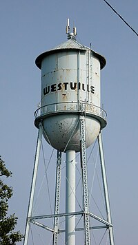
Wanatah is a town in LaPorte County, Indiana, United States. The population was 1,048 at the 2010 census.

<span class="mw-page-title-main">Rome City, Indiana</span> Town in Indiana, United States

Rome City is a town in Orange Township, Noble County, in the U.S. state of Indiana. The population was 1,361 at the 2010 census.

<span class="mw-page-title-main">Grandview, Indiana</span> Town in Indiana, United States

Grandview is a town in Hammond Township, Spencer County, Indiana, along the Ohio River. The population was 749 at the 2010 census.

<span class="mw-page-title-main">Walkerton, Indiana</span> Town in Indiana, United States

Walkerton is a town in Lincoln Township, St. Joseph County, in the U.S. state of Indiana. The population was 2,144 at the 2010 Census. It is part of the South Bend–Mishawaka, IN-MI, Metropolitan Statistical Area.

<span class="mw-page-title-main">Gideon, Missouri</span> City in Missouri, United States

Gideon is a city in New Madrid County, Missouri, United States. The population was 1,093 at the 2010 census.

<span class="mw-page-title-main">Orleans, Indiana</span> Town in Indiana, United States

Orleans is a town in Orleans Township, Orange County, in the U.S. state of Indiana. The population was 2,142 at the 2010 census.

References

  1. "2020 U.S. Gazetteer Files". United States Census Bureau. Retrieved March 16, 2022.
  2. 1 2 U.S. Geological Survey Geographic Names Information System: Westville, Indiana
  3. 1 2 "U.S. Census website". United States Census Bureau . Retrieved January 31, 2008.
  4. History of La Porte County, Indiana: Together with Sketches of Its Cities, Villages, and Townships. C. C. Chapman & Co. 1880. p. 781.
  5. Daniels, E. D. (1904). A twentieth century history and biographical record of La Porte County, Indiana. Lewis Publishing Co. p. 88.
  6. "National Register Information System". National Register of Historic Places . National Park Service. July 9, 2010.
  7. "G001 - Geographic Identifiers - 2010 Census Summary File 1". United States Census Bureau. Archived from the original on February 13, 2020. Retrieved July 25, 2015.
  8. "Census of Population and Housing". Census.gov. Retrieved June 4, 2015.
  9. "U.S. Census website". United States Census Bureau . Retrieved December 11, 2012.
  10. "Indiana public library directory" (PDF). Indiana State Library. Retrieved March 8, 2018.
  11. "How To Get A Library Card". La Porte County Public Library. Retrieved March 8, 2018.