Pottawattamie Park, Indiana

Last updated

Pottawattomie Park, Indiana
LaPorte County Indiana Incorporated and Unincorporated areas Pottawattamie Park Highlighted 1861470.svg
Location of Pottawattamie Park in LaPorte County, Indiana.
Coordinates: 41°43′24″N86°52′02″W / 41.72333°N 86.86722°W / 41.72333; -86.86722
Country United States
State Indiana
County LaPorte
Township Michigan
Area
[1]
  Total0.25 sq mi (0.64 km2)
  Land0.25 sq mi (0.64 km2)
  Water0.00 sq mi (0.00 km2)
Elevation
[2]
623 ft (190 m)
Population
 (2020)
  Total242
  Density983.74/sq mi (380.34/km2)
Time zone UTC-6 (Central (CST))
  Summer (DST) UTC-5 (CDT)
ZIP code
46360 [3]
Area code 219
FIPS code 18-61488 [4]
GNIS feature ID2396865 [2]

Pottawattamie Park is a town in Michigan Township, LaPorte County, Indiana, United States. The population was 235 at the 2010 census. It is included in the Michigan City, Indiana-La Porte, Indiana Metropolitan Statistical Area.

Contents

History

Pottawattamie Park was incorporated in 1936 on land once inhabited by the Potawatomi Indians. [5]

Geography

Pottawattamie Park is completely surrounded by the city of Michigan City.

According to the 2010 census, Pottawattamie Park has a total area of 0.25 square miles (0.65 km2), all land. [6]

Demographics

Historical population
CensusPop.Note
1960 292
1970 37428.1%
1980 284−24.1%
1990 281−1.1%
2000 3006.8%
2010 235−21.7%
2020 2423.0%
U.S. Decennial Census [7]

2010 census

As of the census [8] of 2010, there were 235 people, 102 households, and 68 families living in the town. The population density was 940.0 inhabitants per square mile (362.9/km2). There were 111 housing units at an average density of 444.0 per square mile (171.4/km2). The racial makeup of the town was 92.3% White, 7.2% African American, and 0.4% from two or more races. Hispanic or Latino of any race were 0.4% of the population.

There were 102 households, of which 21.6% had children under the age of 18 living with them, 61.8% were married couples living together, 3.9% had a female householder with no husband present, 1.0% had a male householder with no wife present, and 33.3% were non-families. 29.4% of all households were made up of individuals, and 14.7% had someone living alone who was 65 years of age or older. The average household size was 2.23 and the average family size was 2.76.

The median age in the town was 53.1 years. 18.7% of residents were under the age of 18; 3% were between the ages of 18 and 24; 20.8% were from 25 to 44; 32.4% were from 45 to 64; and 25.1% were 65 years of age or older. The gender makeup of the town was 47.7% male and 52.3% female.

2000 census

As of the census [4] of 2000, there were 300 people, 121 households, and 86 families living in the town. The population density was 1,196.9 inhabitants per square mile (462.1/km2). There were 127 housing units at an average density of 506.7 per square mile (195.6/km2). The racial makeup of the town was 80.00% White, 16.33% African American, 0.67% Asian, 1.33% from other races, and 1.67% from two or more races. Hispanic or Latino of any race were 1.67% of the population.

There were 121 households, out of which 26.4% had children under the age of 18 living with them, 62.0% were married couples living together, 8.3% had a female householder with no husband present, and 28.1% were non-families. 25.6% of all households were made up of individuals, and 15.7% had someone living alone who was 65 years of age or older. The average household size was 2.37 and the average family size was 2.84.

In the town, the population was spread out, with 21.7% under the age of 18, 5.0% from 18 to 24, 22.3% from 25 to 44, 28.7% from 45 to 64, and 22.3% who were 65 years of age or older. The median age was 46 years. For every 100 females, there were 92.3 males. For every 100 females age 18 and over, there were 89.5 males.

The median income for a household in the town was $37,500, and the median income for a family was $46,750. Males had a median income of $63,750 versus $22,292 for females. The per capita income for the town was $24,383. About 3.4% of families and 8.6% of the population were below the poverty line, including 2.9% of those under the age of eighteen and 4.5% of those 65 or over.

Related Research Articles

<span class="mw-page-title-main">Ulen, Indiana</span> Town in Indiana, United States

Ulen is a town in Center Township, Boone County, in the U.S. state of Indiana. The population was 117 at the 2010 census. The town is surrounded by the city of Lebanon.

<span class="mw-page-title-main">Atlanta, Indiana</span> Town in Indiana, United States

Atlanta is a town in Jackson Township, Hamilton County, Indiana, United States. The population was 725 at the 2010 census.

<span class="mw-page-title-main">Shirley, Indiana</span> Town in Indiana, United States

Shirley is a town in Brown Township, Hancock County and Greensboro Township, Henry County, Indiana, United States. The population was 830 at the 2010 census.

<span class="mw-page-title-main">Brownstown, Indiana</span> Town in Indiana, United States

Brownstown is a town within Brownstown Township and the county seat of Jackson County, Indiana, United States. The population was 2,947 at the 2010 census. It was named for Jacob Brown, a general of the War of 1812.

<span class="mw-page-title-main">Silver Lake, Indiana</span> Town in Indiana, United States

Silver Lake is a town in Lake Township, Kosciusko County, in the U.S. state of Indiana. The population was 915 at the 2010 census.

<span class="mw-page-title-main">Bethany, Indiana</span> Town in Indiana, United States

Bethany is a town in Clay Township, Morgan County, in the U.S. state of Indiana. The population was 95 at the 2020 census.

<span class="mw-page-title-main">Paragon, Indiana</span> Town in Indiana, United States

Paragon is a town in Ray Township, Morgan County, in the U.S. state of Indiana. The population was 556 at the 2020 census, down from 659 in 2010.

<span class="mw-page-title-main">Marshall, Indiana</span> Town in Indiana, United States

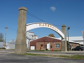
Marshall is a town in Washington Township, Parke County, Indiana, United States. As of the 2010 census, the population was 324.

<span class="mw-page-title-main">Mecca, Indiana</span> Town in Indiana, United States

Mecca is a town in Wabash Township, Parke County, in the U.S. state of Indiana. The population was 335 at the 2010 census.

<span class="mw-page-title-main">Morristown, Indiana</span> Town in Indiana, United States

Morristown is a town in Hanover Township, Shelby County, in the U.S. state of Indiana. The population was 1,218 at the 2010 census.

<span class="mw-page-title-main">Clear Lake, Indiana</span> Town in Indiana, United States

Clear Lake is a town located in the northeast corner of Steuben County, Indiana, in Clear Lake Township. As such, is the northeasternmost community in the State of Indiana. The population was 339 at the 2010 census.

<span class="mw-page-title-main">Shadeland, Indiana</span> Town in Indiana, United States

Shadeland is a town in Union Township, Tippecanoe County, in the U.S. state of Indiana. The population was 1,610 at the 2010 census.

<span class="mw-page-title-main">Fairview Park, Indiana</span> Town in Indiana, United States

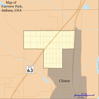
Fairview Park is a town in Clinton Township, Vermillion County, in the U.S. state of Indiana. The population was 1,386 at the 2010 census.

<span class="mw-page-title-main">Avoca, Iowa</span> City in Iowa, United States

Avoca is a city in Pottawattamie County, Iowa, United States. The population was 1,683 at the 2020 census.

<span class="mw-page-title-main">Crescent, Iowa</span> City in Iowa, United States

Crescent is a city in Pottawattamie County, Iowa, United States. The population was 628 at the 2020 census.

<span class="mw-page-title-main">Minden, Iowa</span> City in Iowa, United States

Minden is a city in Pottawattamie County, Iowa, United States. The population was 600 at the time of the 2020 census.

<span class="mw-page-title-main">Neola, Iowa</span> City in Iowa, United States

Neola is a city in Pottawattamie County, Iowa, United States. The population was 918 at the time of the 2020 census.

<span class="mw-page-title-main">Walnut, Iowa</span> City in Iowa, United States

Walnut is a city in Pottawattamie County, Iowa, United States. The population was 747 at the time of the 2020 census. Walnut is located on Interstate 80 and is famous for its many antique stores. In recent years Walnut has become a regional center of wind turbine electrical generation.

<span class="mw-page-title-main">Warren Park, Indiana</span> Town in Indiana, United States

Warren Park is a town in Warren Township, Marion County, Indiana, United States. The population was 1,490 at the 2020 census. It has existed as an "included town" since 1970, when it was incorporated into Indianapolis as part of Unigov. It is part of Indianapolis, but retains a functioning town government under IC 36-3-1-11.

<span class="mw-page-title-main">Williams Creek, Indiana</span> Town in Indiana, United States

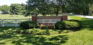
Williams Creek is a town in Washington Township, Marion County, Indiana, United States. It is located about 9 miles (14 km) north of downtown Indianapolis. The population was 430 at the 2020 census. It has existed as an "included town" since 1970, when it was incorporated into Indianapolis as part of Unigov. It is part of Indianapolis, but retains a functioning town government under IC 36-3-1-11.

References

  1. "2020 U.S. Gazetteer Files". United States Census Bureau. Retrieved March 16, 2022.
  2. 1 2 U.S. Geological Survey Geographic Names Information System: Pottawattamie Park, Indiana
  3. "Pottawattamie Park IN ZIP Code". zipdatamaps.com. 2023. Retrieved December 7, 2023.
  4. 1 2 "U.S. Census website". United States Census Bureau . Retrieved January 31, 2008.
  5. Schoon, Kenneth J. (June 18, 2013). Dreams of Duneland: A Pictorial History of the Indiana Dunes Region. Indiana University Press. p. 219. ISBN   0-253-00798-4.
  6. "G001 - Geographic Identifiers - 2010 Census Summary File 1". United States Census Bureau. Archived from the original on February 13, 2020. Retrieved July 17, 2015.
  7. "Census of Population and Housing". Census.gov. Retrieved June 4, 2015.
  8. "U.S. Census website". United States Census Bureau . Retrieved December 11, 2012.