
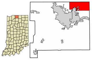
St. Joseph County, commonly called St. Joe County by residents, is a county located in the U.S. state of Indiana. As of the 2020 census, the population was 272,912, making it the fifth-most populous county in Indiana. Formed in 1830, it was named for the St. Joseph River which flows through it to Lake Michigan. The county seat is South Bend. St. Joseph County is part of the South Bend–Mishawaka, IN–MI "Michiana", Metropolitan Statistical Area.

Elkhart County is a county located in the U.S. state of Indiana. As of 2020, the county's population was 207,047. The county seat is Goshen. Elkhart County is part of the Elkhart-Goshen Metropolitan Statistical Area, which in turn is part of the South Bend-Elkhart-Mishawaka Combined Statistical Area. It is also considered part of the broader region of Northern Indiana known as Michiana, and is 20 miles (32 km) east of South Bend, Indiana, 110 miles (180 km) east of Chicago, Illinois, and 150 miles (240 km) north of Indianapolis, Indiana. The area is referred to by locals as the recreation vehicle (RV) capital of the world and is known for its sizable Amish and Old Order Mennonite population.

Garrett is a city in Keyser Township, DeKalb County, Indiana, United States. The population was 6,286 at the 2010 census.

Saint Joe is a town in Concord Township, DeKalb County, Indiana, United States. The population was 460 at the 2010 census.
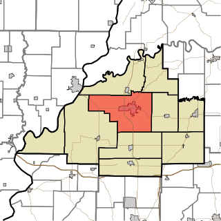
Granger is a census-designated place (CDP) in Clay and Harris townships, St. Joseph County, in the U.S. state of Indiana. The population was 30,465 at the 2010 census. Penn-Harris-Madison School Corporation and the South Bend Community School Corporation maintain the public schools in the area. Granger is part of the South Bend–Mishawaka metropolitan area as well as the larger Michiana region.

Mishawaka is a city on the St. Joseph River, in Penn Township, St. Joseph County, in the U.S. state of Indiana. The population was 51,063 as of the 2020 census. Its nickname is "the Princess City". Mishawaka is a principal city of the South Bend–Mishawaka, IN-MI, Metropolitan Statistical Area.

Wyatt is an unincorporated community located in Madison Township, St. Joseph County, in the U.S. state of Indiana.

Deeth is an unincorporated community and census-designated place near the intersection of Interstate 80 and Nevada State Route 230 in Elko County, Nevada, United States.
Patoka Township is one of ten townships in Gibson County, Indiana, United States. As of the 2010 census, its population was 11,864 and it contained 5,341 housing units. It is the largest township in population, accounting for roughly 30% of the county's total population.

Saint Joseph Township is one of twenty townships in Allen County, Indiana, United States. As of the 2010 census, its population was 72,245.
Tetersburg is an unincorporated community in Jefferson Township, Tipton County, in the U.S. state of Indiana.
Boyleston is an unincorporated community in Michigan Township, Clinton County, Indiana.
Fickle is an unincorporated community in Washington Township, Clinton County, Indiana.
Forest is an unincorporated community in Forest Township, Clinton County, Indiana.
Scircleville is an unincorporated community in Johnson Township, Clinton County, Indiana. Scircleville was named in honor of George Scircle.

Cornettsville is an unincorporated community in Bogard Township, Daviess County, Indiana, United States.
Plainfield is an unincorporated community in St. Joseph County, Indiana, United States. It is along U.S. Route 20 in the north-central part of Olive Township and is bordered to the south and west by the town of New Carlisle. Via US-20, Plainfield is 13 miles (21 km) west of South Bend and 23 miles (37 km) east of Michigan City.
Prosperity is an unincorporated community in Lafayette Township, Madison County, Indiana.

DeKalb County is a county in the U.S. state of Indiana. As of the 2020 United States Census, the population was 43,265. The county seat is Auburn.


