
Putnam County is a county located in the U.S. state of Indiana. As of the 2020 United States Census, the population was 36,726. The county seat is Greencastle. The county was named for Israel Putnam, a hero in the French and Indian War and a general in the American Revolutionary War. The county was created in 1821 and organized in April 1822.

Gilmer County is a county in the U.S. state of West Virginia. As of the 2020 census, the population was 7,408, making it West Virginia's fifth-least populous county. Its county seat is Glenville. The county was formed in 1845 from parts of Lewis and Kanawha Counties, and named for Thomas Walker Gilmer, Governor of Virginia from 1840 to 1841. Gilmer was later a representative in the United States Congress and Secretary of the Navy in President John Tyler's cabinet.

St. Joseph County, commonly called St. Joe County by residents, is a county located in the U.S. state of Indiana. As of the 2020 census, the population was 272,912, making it the fifth-most populous county in Indiana. Formed in 1830, it was named for the St. Joseph River which flows through it to Lake Michigan. The county seat is South Bend. St. Joseph County is part of the South Bend–Mishawaka, IN–MI "Michiana", Metropolitan Statistical Area.

Porter County is a county in the U.S. state of Indiana. As of 2020, the population was 173,215, making it the 10th most populous county in Indiana. The county seat is Valparaiso. The county is part of Northwest Indiana, as well as the Chicago metropolitan area. Porter County is the site of much of the Indiana Dunes, an area of ecological significance. The Hour Glass Museum in Ogden Dunes documents the region's ecological significance.

Kosciusko County is a county in the U.S. state of Indiana. At the 2020 United States Census, its population was 80,240. The county seat is Warsaw.

Gilmer County is a county located in the north central portion of the U.S. state of Georgia. As of the 2020 census, the population was 31,353. The county seat is Ellijay. It was based on a historic Cherokee town also spelled as Elejoy in the eighteenth century. The county was created on December 3, 1832, and was named for George Rockingham Gilmer, a politician who served two non-consecutive terms as governor of the state. Gilmer County is home of the annual Apple Festival, which is held in mid-October. Ninety percent of the land is in cropland and forest. Poultry raising and processing makes up the largest portion of the agricultural economy, which generates 33.2% of the total revenues. Manufacturing is about 20%.

Terre Haute is the city that holds the county seat of Vigo County, Indiana, United States, about 5 miles east of the state's western border with Illinois. As of the 2020 census, the city had a population of 58,389 and its metropolitan area had a population of 168,716.

Greenwood is a city in Johnson County, Indiana, United States. The population was 63,830 at the 2020 Census. Greenwood is located southeast of central Indianapolis between Indiana State Road 37 and Interstate 65. The city shares a border with Indianapolis and is the most populous suburban municipality in the southern portion of the Indianapolis Metropolitan Area.

Valparaiso, colloquially Valpo, is a city and the county seat of Porter County, Indiana, United States. The population was 34,151 at the 2020 census.
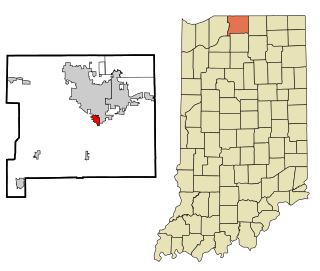
Gulivoire Park is a census-designated place (CDP) in Centre Township, St. Joseph County, in the U.S. state of Indiana. The population was 2,974 at the 2000 census. It is part of the South Bend–Mishawaka, IN-MI, Metropolitan Statistical Area.

U.S. Route 271 is a north–south United States highway. Never a long highway, it went from bi-state route to a tri-state route. Its southern terminus is in Tyler, Texas, at an intersection with State Highway 31 and SH 155. The highway's northern terminus is in Fort Smith, Arkansas, at an intersection with Business U.S. Route 71 and Highway 255. It enters Arkansas from Oklahoma as a controlled-access highway, but the highway continues as Interstate 540 when US 271 exits toward downtown after one-half mile (800 m) in Arkansas.

Indiana Dunes National Park is a United States national park located in northwestern Indiana managed by the National Park Service. It was authorized by Congress in 1966 as the Indiana Dunes National Lakeshore and was redesignated as the nation's 61st national park on February 15, 2019. The park runs for about 20 miles (32 km) along the southern shore of Lake Michigan and covers 15,349 acres (6,212 ha). Along the lakefront, the eastern area is roughly the lake shore south to U.S. 12 or U.S. 20 between Michigan City, Indiana, on the east and the Cleveland-Cliffs steel plant on the west. To the west of the steel plant lies West Beach and a small extension south of the steel mill continues west along Salt Creek to Indiana 249. The western area is roughly the shoreline south to U.S. 12 between the Burns Ditch west to Broadway in downtown Gary, Indiana. The area conservation scheme is enhanced by the older Indiana Dunes State Park. In addition, there are several outlying areas, including Pinhook Bog, in LaPorte County to the east; the Heron Rookery in Porter County, the center of the park; and the Calumet Prairie State Nature Preserve and the Hobart Prairie Grove, both in Lake County, the western end of the park.
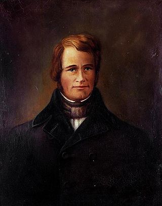
Thomas Walker Gilmer was an American statesman. He served in several political positions in Virginia, including election as the 28th Governor of Virginia. Gilmer's final political office was as the 15th Secretary of the Navy, but he died in an accident ten days after assuming that position.

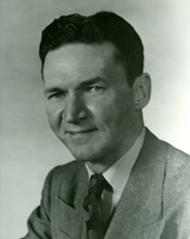
William Gilmer Bray was an American lawyer and World War II veteran who served twelve terms as a Republican member of the United States House of Representatives from Indiana from 1951 to 1975.
William Franklin "Dixie" Gilmer was an American politician and a U.S. Representative from Oklahoma.

It's Not Big It's Large is an album by Lyle Lovett and his Large Band, released in 2007. The recording was made live in studio.
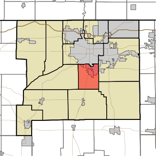
Centre Township is one of thirteen townships in St. Joseph County, in the U.S. state of Indiana. As of the 2010 census, its population was 14,350.
Gilmer is a neighborhood in central Roanoke, Virginia, USA, abutting the Norfolk Southern rail yard that initially developed in the 1920s as an early Roanoke suburb. It borders the neighborhoods of Harrison on the north, Gainsboro to the east and Loudon-Melrose to the west. Both the West End and Hurt Park are to the south and can be accessed via the 10th Street Bridge across the railroad gulch. Founded in 1980, the Northwest Neighborhood Environmental Organization is the community development corporation active within the Gilmer neighborhood.

Stumptown Wildlife Management Area is located in both Calhoun and Gilmer Counties near the community of Stumptown, West Virginia. Stumptown WMA is located on 1,675 acres (678 ha) of hilly terrain, mostly covered with mixed oak and pine forest, with stands of mixed hardwoods.

This is a list of the National Register of Historic Places listings in Gilmer County, West Virginia.


